TROPICAL STORM WILFRED WEAKENS TO A DEPRESSION AND IS FORECAST TO DISSIPATE WELL EAST OF THE ISLANDS BY TUESDAY

IF WILFRED SURVIVES BEYOND TUESDAY, ALL MODELS HAVE IT STEERING CLEAR OF THE ISLANDS. HENCE, BASED ON THE REASONABLE WORST-CASE SCENARIO, THE CYCLONE POSES NO THREAT TO MONTSERRAT.

RESIDENTS SHOULD CONTINUE TO MONITOR THE ATLANTIC AND STAY PREPARED. YOU CAN SEE THE FULL STATEMENT BELOW FROM THE ANTIGUA AND BARBUDA METEOROLOGICAL SERVICES ON TROPICAL DEPRESSION WILFRED:

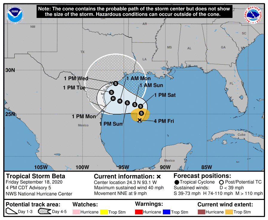
BREAKING: TROPICAL STORM BETA FORMS IN THE GULF OF MEXICO FRIDAY AFTERNOON, RIGHT BEHIND TROPICAL STORM WILFRED AND SUBTROPICAL STORM ALPHA

Three (3) Atlantic named storms were formed today Friday, September 18, 2020 – Wilfred, Alpha and Beta. The only other time on record that the Atlantic had 3 named storm formations on the same calendar day was August 15, 1893. So far, this hurricane season, there have been 23 named storms. First came Tropical Storm Wilfred in the Atlantic around 11 am, then Subtropical Storm Alpha near Portugal at 12:30 pm. Tropical Storm Beta, in the Gulf of Mexico, broke the record around 5 pm. Beta could become a hurricane while moving slowly over the Gulf of Mexico during the next few days, according to the National Hurricane Center.

Image

BREAKING: TROPICAL STORM WILFRED FORMS IN THE EASTERN ATLANTIC; ITS FORECAST TO STAY CLEAR OF THE CARIBBEAN WHICH INCLUDES MONTSERRAT

Wilfred was centered about 630 miles west-southwest of the Cabo Verde Islands and was moving west-northwest near 17 mph. Location 11.9N 32.4W. The storm comes amid a very active hurricane season in the Atlantic and “Wilfred” is the last name on the Hurricane Center’s list of storm names for the season. As the hurricane season is far from over, any other storms that form this year will be given letters of the Greek alphabet. The Greek alphabet has only been used once before, during the catastrophic 2005 hurricane season when Hurricane Katrina devastated New Orleans. That year, Wilma was named on October 17th, a full month later than we’re reaching “W” this year.

HURRICANE TEDDY STRENGTHENING, BUT STEERING CLEAR OF MONTSERRAT MOVING NORTHWEST AT AROUND 12 MPH. – ALL THE MODELS SURVEYED HAVE THE CENTRE OF TEDDY PASSING WELL AWAY FROM THE CARIBBEAN. HENCE, BASED ON THE REASONABLE WORST-CASE SCENARIO, THE CYCLONE POSES NO WIND THREAT TO MONTSERRAT AND WILL PASS SEVERAL HUNDRED MILES AWAY FROM THE REGION, ON THURSDAY

RESIDENTS SHOULD CONTINUE TO MONITOR TEDDY AND STAY PREPARED FOR THE REST OF THE HURRICANE SEASON.

YOU CAN SEE THE FULL STATEMENT BELOW FROM THE ANTIGUA AND BARBUDA METEOROLOGICAL SERVICES ON HURRICANE TEDDY: