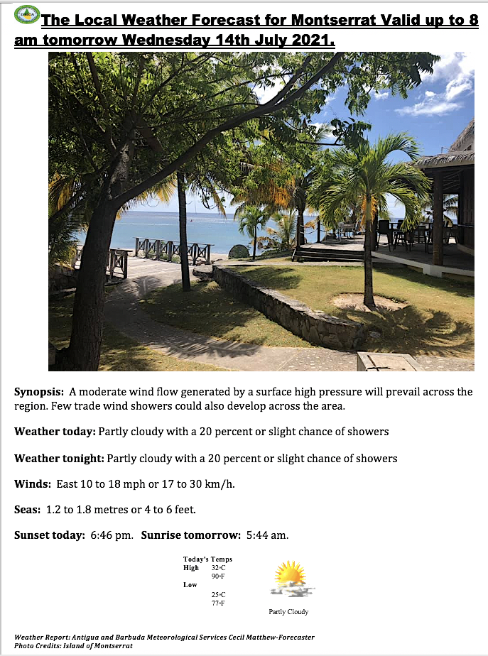
Synopsis: Some pockets of moisture moving across the region on the tradewinds will maintain a moderate chance of showers across the islands today. Dry and stable air settling over the islands tonight will reduce the chances of showers.
Today: Partly sunny with a 50 percent or moderate chance of showers.
Tonight: Partly cloudy with a 30 percent or low chance of showers.
Winds: East at 24 to 37 km/h or 15 to 23 mph with gusts possibly peaking to near 56 km/h or 35 mph..
Seas: 1.2 to 1.8 metres or 4 to 6 feet..
Sunset today: 6:46 pm. Sunrise tomorrow: 5:46 am.
Weather Report: Antigua and Barbuda Meteorological Services Lorne Salmon-Forecaster
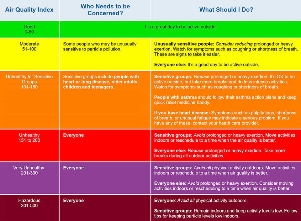
The Antigua and Barbuda Meteorological Services issued the following Air Quality Bulletin on Saturday July 17, 2021 @ 9: 50 pm.
Air Quality Index Based on Particulate Matters 2.5 (PM2.5) and 10 (PM10) Concentration
Air quality category: Moderate
Location: Montserrat
Timing: Until Wednesday
Synopsis: The air quality is reduced to moderate levels, as a result of an increase of particulate matters 2.5 and 10, associated with a fresh surge in Saharan Dust. The threat of health problems is elevated, for mainly unusually sensitive people, such as asthmatics.
Air quality index: 50 to 80
Alert Level: II
Sensitive groups: People with respiratory or heart disease, the elderly and children are the groups most at risk.
Health implications: Air quality is acceptable; however, for some pollutants there may be a moderate health concern for a very small number of people who are unusually sensitive to air pollution.
Caution: Active children and adults, and people with respiratory disease, such as asthma, should limit prolonged outdoor exertion.
Remember, the weather can change at a moment’s notice, Stay Ahead! Events such as flash floods can occur with little or no warning due to prolonged rain, rain showers in the higher elevations and the soil already saturated.
Seas: moderate with waves up to 4.9 feet or 1.5 metres.
Winds: fresh to strong easterly winds ranging from 17 to 25 knots.
Remember, Think about boat safety and plan your trip before you go. Knowledge and planning reduce the risks and increase the fun. Always tell someone where you will be going, when you expect to return, and what your boat looks like. Keep in mind that there might not be cell phone coverage where you are heading!
Tropical Storm Elsa is forecast to stay clear of the area
This Is For The Leeward Islands And British Virgin Islands.
The Antigua and Barbuda Meteorological Services continues to closely monitor the progress of Tropical Storm Elsa, which was Potential Tropical Cyclone Five.
The system is forecast to become a strong tropical storm in 24 hours and impact parts of the Caribbean.
There is growing confidence that the centre of Tropical Storm Elsa will pass a safe distance, over 200 miles, away from the northeast Caribbean and spare the area any sustained storm-force winds and most of the other associated storm hazards. thus, the general threat levels, especially with respect to wind, remain, at this time, little to none, for the Leeward and the British Virgin Islands. Therefore, no immediate preparations are required. Notwithstanding, have your hurricane disaster plans prepared and monitor this system closely.
At 2 pm, Tropical Storm Elsa was located near latitude 10.6 north, longitude 52.6 west or about 755 miles southeast of the leeward islands moving rapidly west-northwest at 28 mph.
Maximum Sustained Winds Are Around 45 Mph With Higher Gusts. Strengthening Is Forecast During The Next 48 Hours.
On its Forecast Track, Elsa will most likely pass through the windward islands Friday morning. please note that no alerts, watches or warnings are in effect, at this time, and this is unlikely to change.
Residents should continue to monitor this developing system closely and have their hurricane plans prepared, for the rest of the Hurricane Season.
That’s according to an Air Quality Bulletin issued by the Antigua and Barbuda Meteorological Services at 3:40 pm on Thursday, July 1, 2021.
It states that although the air quality is acceptable, for some pollutants there may be a moderate health concern for a very small number of people who are unusually sensitive to air pollution.
Air Quality Index Based on Particulate Matters 2.5 (PM2.5) and 10 (PM10) Concentration.
Air quality category: Moderate
Synopsis: The air quality is down to moderate levels, as a result of an increase of particulate matters 2.5 and 10, associated with a fresh surge in Saharan Dust. The threat of health problems is elevated, for mainly unusually sensitive people, such as asthmatics.
Air quality index: 50 to 80
Alert Level: II
Sensitive groups: People with respiratory or heart disease, the elderly and children are the groups most at risk.
Health implications: Air quality is acceptable; however, for some pollutants, there may be a moderate health concern for a very small number of people who are unusually sensitive to air pollution.
Caution: Active children and adults, and people with respiratory diseases, such as asthma, should limit prolonged outdoor exertion.
Locations to be affected: Especially open Atlantic waters.
Timing: Friday 8 am to Saturday 8 am.
Synopsis: Fresh to strong gusty winds, owing to expected further steepening of the pressure gradient, due to the passage of Tropical Storm Elsa, are expected to cause hazardous seas. The threat level to the life, livelihood, property and infrastructure of mariners is high, and there is the potential for extensive impacts. A small craft warning means that wind speeds of 41 km/h or higher (22 knots or higher) and or wind waves and or wind swells of 9 feet or greater are occurring or expected.
Winds over open waters: East at 33 to 52 km/h (18 to 28 knots; 21 to 32 mph), with strong gusts to gale-force – 69 km/h (37 knots; 43 mph).
Seas (significant wave heights): 2 to 3.5 metres (7 to 12 feet), occasionally or locally exceeding 4.5 metres (15 feet). Wind waves and or wind swells: 2 to 2.8 metres or 6 to 9 feet and occasionally higher. The dominant wind wave period is 6 to 9 seconds.
Potential impacts: Loss of life; injuries; damage or loss of boats and fishing equipment; sea search and rescue disruptions; cancellations to sea transportation; scarcity of sea food; cancellation to marine recreation and businesses and economic losses.
Caution: Small craft operators should stay in or near port.
Please continue to monitor these hazardous, life-threatening marine conditions.
THIS IS FOR THE LEEWARD ISLANDS WHICH INCLUDES MONTSERRAT AND THE BRITISH VIRGIN ISLANDS.
THE ANTIGUA AND BARBUDA METEOROLOGICAL SERVICES IS CLOSELY FOLLOWING THE PROGRESS OF TROPICAL DISTURBANCE AL97, WHICH HAS THE POTENTIAL TO BECOME A TROPICAL CYCLONE IN 48 HOURS AND IMPACT PARTS OF THE CARIBBEAN.
GIVEN THE UNCERTAINTY IN THE FORECAST TRACK, INTENSITY AND SIZE OF THE POTENTIAL TROPICAL CYCLONE, IT IS IMPOSSIBLE TO PREDICT WHAT EXACT TROPICAL-CYCLONE-HAZARD VALUES, IF ANY, ARE EXPECTED OR LIKELY TO OCCUR THIS FAR IN ADVANCE. NOTWITHSTANDING, THE DISTURBANCE COULD BE IN THE AREA FRIDAY/SATURDAY, AS A STRONG TROPICAL STORM OR HURRICANE. HOWEVER, AT THIS TIME, THE DISTURBANCE POSES LITTLE TO NO THREAT TO THE LEEWARD AND BRITISH VIRGIN ISLANDS. THUS, NO IMMEDIATE PREPARATIONS ARE REQUIRED AT THIS TIME. NOTWITHSTANDING, HAVE YOUR HURRICANE DISASTER PLANS PREPARED AND MONITOR THIS SYSTEM CLOSELY.
AT 8 AM, TROPICAL DISTURBANCE AL97, WAS LOCATED ABOUT 1620 MILES EAST-SOUTHEAST OF THE LEEWARD ISLANDS MOVING WEST-NORTHWEST AT AROUND 20 MPH.MAXIMUM SUSTAINED WINDS ARE AROUND 35 MPH WITH HIGHER GUSTS. STRENGTHENING IS FORECAST AND THE DISTURBANCE IS LIKELY TO BECOME A TROPICAL DEPRESSION IN A COUPLE DAYS.
ON ITS FORECAST TRACK, THE SYSTEM WILL MOST LIKELY PASS THROUGH THE WINDWARD ISLANDS; HOWEVER, ANY PERSISTENT WEST-NORTHWEST TRACK COULD BRING IT DANGEROUSLY CLOSE TO ANTIGUA AND BARBUDA AND THE NORTHEAST CARIBBEAN. THERE IS STILL A LOT OF UNCERTAINTY AND A LOT OF TIME FOR UNEXPECTED CHANGES TO TAKE PLACE.
PLEASE NOTE THAT NO ALERTS, WATCHES OR WARNINGS ARE IN EFFECT AT THIS TIME BUT THIS COULD CHANGE IN THE NEXT 24 HOURS.
RESIDENTS SHOULD MONITOR THIS DEVELOPING SYSTEM CLOSELY AND HAVE THEIR HURRICANE PLANS PREPARED, IN THE EVENT THE SYSTEM TAKES AN UNEXPECTED PATH AND COME TOWARD THE NORTHEAST CARIBBEAN ISLANDS.AN UPDATE WILL BE GIVEN AROUND 5 PM THIS AFTERNOON OR SOONER IF NEEDED.
Montserrat is already experiencing the effects of Disturbance 1 forecasted to bring increased rainfall over the next 24 hours to the island. Residents and visitors are asked to monitor the systems and stay prepared.
The DMCA will continue to provide regular updates until the system dissipates or passes us.
The National Hurricane Center issued the following advisories @ 8 am on the disturbances:
Disturbance 1 – A broad area of low pressure, associated with a tropical wave, is located about midway between the west coast of Africa and the Windward Islands. This system is producing a large area of showers and thunderstorms that continues to show some signs of organization. Environmental conditions appear generally favourable for development, and a tropical depression is likely to form during the next few days while the system moves west-northwestward at about 20 mph. Interests in the Windward and Leeward Islands should closely monitor this system as it will likely be moving through that region on Friday. Formation chance through 48 hours…60%. Formation chance through 5 days…80%.
Disturbance 2 – Disorganized showers and thunderstorms continue in association with a tropical wave located just east of the Lesser Antilles. Significant development of this system is unlikely while it moves quickly westward to west-northwestward at 20 to 25 mph, passing through the Lesser Antilles today and then across the eastern and central Caribbean Sea later this week. Regardless of development, this system could bring locally heavy rainfall to portions of the Lesser Antilles during the next day or two. Formation chance through 48 hours…10%. Formation chance through 5 days…10%.
Partly cloudy to cloudy with a 60% chance of showers today and, small craft operators should be cautious against choppy seas.
Remember, the weather can change at a moment’s notice, Stay Ahead! Events such as flash floods can occur with little or no warning due to prolonged rain, rain showers in the higher elevations and the soil already saturated!