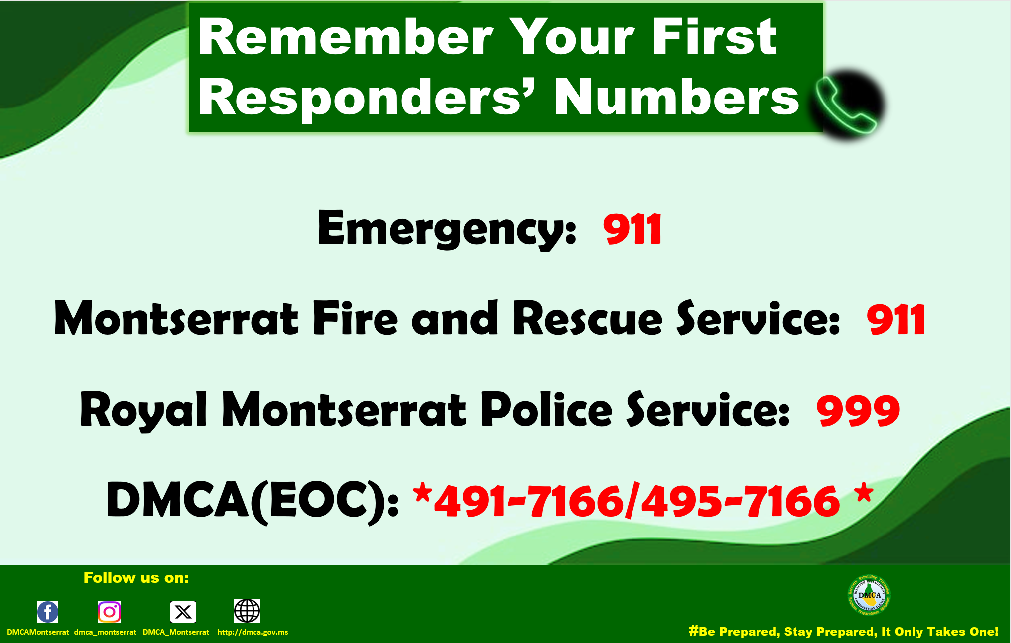
Emergencies can happen to anyone, anywhere, at any time, and may be caused by natural events such as a hurricane or human action.
Place emergency contact information in an easily accessible location for all family members such as on the refrigerator, and ensure your children know the numbers.
Remember, to Save First Responders contacts on your phone, so it’s easily accessible in an emergency.
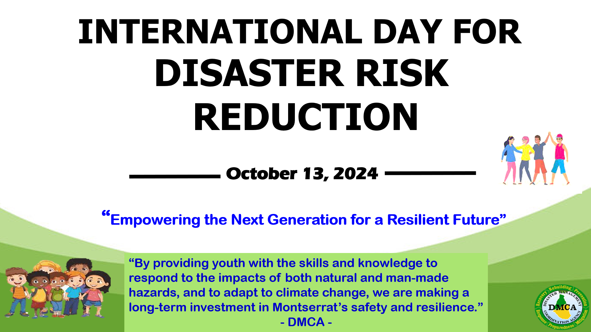
Yellow Hill Road: Today, Sunday, October 13, 2024, the Disaster Management Coordination Agency (DMCA) joins the global community in observing International Day for Disaster Risk Reduction, under the theme “Empowering the Next Generation for a Resilient Future.”
This theme resonates with the DMCA’s long-term commitment to equip Montserrat’s youth with the knowledge and skills necessary to take timely and effective actions to reduce their risks to various natural and technological hazards, in order to save lives and assist others. Through ongoing initiatives such as tsunami and earthquake drills, youth engagement in disaster risk reduction activities, and the annual DMCA Hurricane Preparedness Summer Programme, the agency works to build resilience across generations.
While the DMCA’s support for youth is continuous, the agency is particularly proud of its role in assisting volunteers like Darenthea Sweeney, who is passionate about disaster management and addressing the effects of climate change on Montserrat. Ms. Sweeney recently completed the Caribbean Climate Justice Leaders course, organized by Island Innovation, and represented Montserrat at a Climate Change and Health Workshop in Guyana. She plans to pursue postgraduate studies in Crisis and Disaster Management and Climate Change, furthering her impact in these critical areas.
Similarly, the DMCA continues to support and assist TiVonne Howe, a dedicated young Montserratian pursuing her doctorate in volcanology. Ms. Howe’s commitment to understanding volcanic hazards and minimizing their effects on communities reflects her deep passion for disaster resilience. The DMCA remains dedicated to helping her complete her studies and contribute to Montserrat’s disaster preparedness.
Recognizing that today’s youth are the leaders of tomorrow, the DMCA collaborates year-round with educators—from early childhood to tertiary levels—and community groups to promote disaster awareness and preparedness. These efforts are designed to empower the next generation with the tools to build a greener, safer, and more climate-resilient Montserrat.
As we observe this year’s International Day for Disaster Risk Reduction, the DMCA reaffirms its ongoing dedication to nurturing youth as future leaders in resilience. By providing them with the skills and knowledge to respond to the impacts of both natural and man-made hazards, and to adapt to climate change, we are making a long-term investment in Montserrat’s safety and resilience. With the energy and innovation of our youth, we can build a future where our communities are better prepared for the challenges ahead. The work we do every day helps shape the resilient Montserrat of tomorrow.
About the DMCA
The Disaster Management Coordination Agency (DMCA) is the lead agency responsible for disaster preparedness, mitigation, response, and recovery in Montserrat. Through proactive planning, public education, and timely information dissemination, the DMCA works to minimize risks and ensure the safety and well-being of the people of Montserrat.
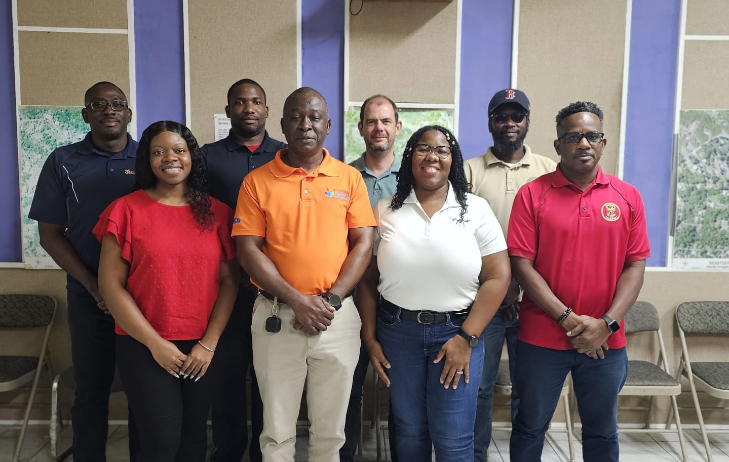
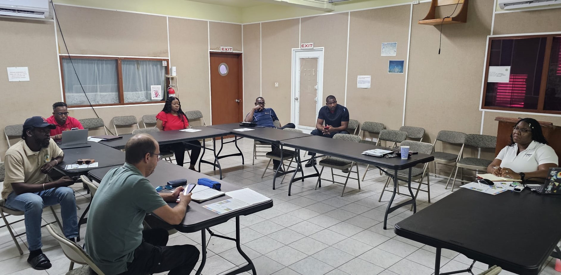
A stakeholder engagement session was held on Friday, 11 October 2024, in Montserrat, aimed at equipping drone operators and key agencies with the skills necessary to operate Unmanned Aerial Systems (UASs) within the framework of the Comprehensive Disaster Management (CDM) Programme.
The use of UAS technology in disaster management has seen significant growth in recent years, offering critical capabilities in the aftermath of natural disasters such as hurricanes, earthquakes, volcanic eruptions, and floods. These systems provide vital support for aerial surveillance, search and rescue operations, damage assessments, mapping, communication, coordination, and the delivery of essential supplies during emergencies.
With the support of Global Support and Development (GSD), the Caribbean Disaster Emergency Management Agency (CDEMA) has launched the “UAS for Humanitarian Operations Consultancy.” This initiative aims to establish a UAS component within the CDM Programme across all CDEMA participating states.
The programme seeks to create an internationally recognized certification for UAS operators, producing a highly trained cadre of facilitators and operators. These individuals will be equipped with regional certifications, necessary permissions, and comprehensive knowledge, enabling them to respond effectively to emergencies and support the Regional Response Mechanism (RRM) in all phases of CDM operations.
Led by CDEMA’s Regional Training Centre, the initiative is being conducted in collaboration with the University of the West Indies, Technical and Vocational Education and Training (TVET) Councils, UNICEF Drone Academy, and the National Institute for Science and Technology. These institutions are responsible for overseeing the programme’s standardization, evaluation, certification, and accreditation processes.
CDEMA envisions that this initiative will strengthen efforts toward a more resilient Caribbean, one that is better equipped to address the risks and losses associated with natural and technological hazards, as well as the impacts of climate change. This initiative aligns with the region’s goals for long-term sustainable development.
The workshop, held at the DMCA conference room, was facilitated by Consultant Lavern Rogers-Ryan of LRR Geospatial Consultancy.
About the DMCA
The Disaster Management Coordination Agency (DMCA) is the lead agency responsible for disaster preparedness, mitigation, response, and recovery in Montserrat. Through proactive planning, public education, and timely information dissemination, the DMCA works to minimize risks and ensure the safety and well-being of the people of Montserrat.
The Disaster Management Coordination Agency (DMCA) is excited to announce the official launch of Montserrat Weather on social media, a new initiative aimed at providing the public with up-to-date, Montserrat-specific weather information.
Montserrat Weather is now live on Facebook, Instagram, and Twitter, with plans to add a dedicated weather extension on the DMCA’s official website at dmca.gov.ms.
This platform is part of the DMCA’s ongoing efforts to streamline its communication strategy, enabling its primary social media channels to focus on the core functions of disaster risk reduction. These core functions include prevention, preparedness, response, and recovery phases. By creating dedicated platforms for Montserrat Weather, the DMCA can ensure weather updates receive full public attention without overwhelming the disaster management content.
“Time-critical information shared through our social media platforms during an emergency can help save lives,” said Shirlian Queeley, Information and Education Officer at the DMCA. “Having Montserrat Weather as a separate entity allows us to better manage and disseminate weather-specific updates while keeping a clear focus on disaster management communications.”
With weather patterns playing a crucial role in disaster preparedness and response, Montserrat Weather will provide real-time updates, forecasts, and alerts to ensure residents remain informed and prepared for any situation. The separation of Montserrat Weather from the DMCA’s main platforms ensures that both weather-related and disaster management content are communicated effectively, without confusion.
The DMCA encourages all residents and visitors to follow Montserrat Weather on Facebook, Instagram, and Twitter for timely weather updates. Those not on social media can tune in to ZJB Radio for daily weather reports.
For more information, visit dmca.gov.ms or contact the DMCA at 1-664-491-7166.
About the DMCA
The Disaster Management Coordination Agency (DMCA) is the lead agency responsible for disaster preparedness, mitigation, response, and recovery in Montserrat. Through proactive planning, public education, and timely information dissemination, the DMCA works to minimize risks and ensure the safety and well-being of the people of Montserrat.
Media Contact: Shirlian Queeley Information and Education Officer DMCA Phone: 1-664-491-7166 Email: queeleys@gov.ms
September is the month we love to hate and hate to love – a stark reminder that, as Montserratians, we must not allow the trials of September 17th to dampen our spirits. Instead, let them inspire us to stay prepared for all natural and man-made hazards, avoid complacency, remain vigilant, and stay informed.
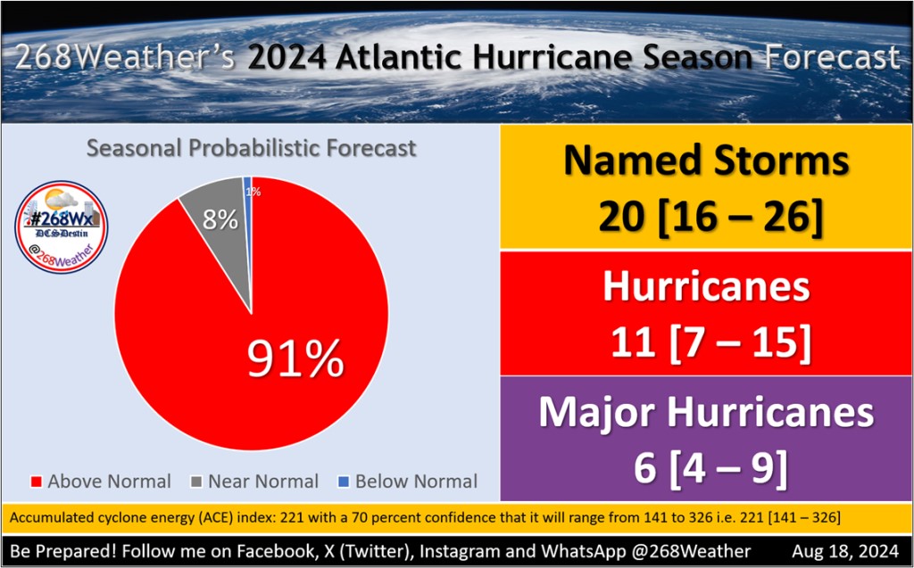
His latest forecast calls for 20 named storms, 11 hurricanes, and 6 major hurricanes, with an Accumulated Cyclone Energy (ACE) of 221. These numbers are higher than average and suggest a potentially intense season.
The primary factors driving this prediction are unusually warm sea surface temperatures across the tropical North Atlantic and cooler-than-normal temperatures in the eastern Equatorial Pacific, conditions often associated with La Niña. These factors typically enhance hurricane development and intensity.
However, Destin also notes that there are uncertainties, particularly regarding the impact of Saharan dust. This dust can suppress hurricane formation, but its intensity and timing are difficult to predict beyond a few days, adding a layer of uncertainty to the overall forecast.
As we move into the peak of the hurricane season (August to October), the situation will require close monitoring.