Yellow Hill, Montserrat – July 24, 2020 – A tropical wave located about 300 miles southeast of the Cabo Verde Islands is producing an area of cloudiness and disorganized thunderstorms. The disturbance is expected to move westward across the tropical Atlantic during the next several days, and some gradual development of this system is possible by early next week when it reaches the western tropical Atlantic.
* Formation chance through 48 hours…low…near 0 percent. * Formation chance through 5 days…low…30 percent. Forecaster Stewart
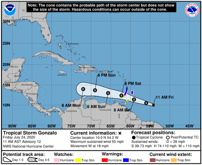
Yellow Hill, Montserrat – July 24, 2020 – At 1100 AM, the center of Tropical Storm Gonzalo was located near latitude 10.0 North, longitude 54.2 West. Gonzalo is moving toward the west near 18 mph (30 km/h). A general westward- to west-northwestward motion is expected during the next couple of days. On the forecast track, the center of Gonzalo will approach the southern Windward Islands tonight and then move across the islands on Saturday and over the eastern Caribbean Sea on Sunday.
Maximum sustained winds are near 50 mph (85 km/h) with higher gusts. There is considerable uncertainty in the intensity forecast, but some strengthening is still possible during the next day or so before Gonzalo reaches the southern Windward Islands. Weakening is expected after Gonzalo moves into the Caribbean Sea, and the cyclone is expected to dissipate by the middle of next week.
Gonzalo is a small tropical cyclone. Tropical-storm-force winds extend outward up to 25 miles (35 km) from the center. The estimated minimum central pressure is 1002 mb (29.59 inches).
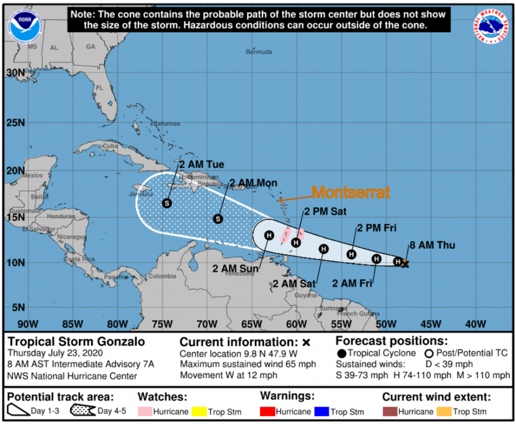
Yellow Hill, Montserrat – July 23, 2020 – At 800 AM, the center of Tropical Storm Gonzalo was located near latitude 9.8 North, longitude 47.9 West. Gonzalo is moving toward the west near 12 mph (19 km/h). A general westward motion at a faster forward speed is expected today followed by a turn toward the west-northwest on Saturday. On the forecast track, the center of Gonzalo would approach the Windward Islands late Friday and Saturday.
Maximum sustained are near 65 mph (100 km/h) with higher gusts. Strengthening is forecast during the next couple of days, and Gonzalo could become a hurricane later today.
Tropical-storm-force winds extend outward up to 35 miles (55 km) from the center.
The estimated minimum central pressure is 997 MB (29.44 inches).
AS THE PEAK MONTHS OF THE HURRICANE SEASON DRAW NEAR; RESIDENTS, VISITORS AND BUSINESSES ARE ASKED TO ASSESS THEIR RISK NOW, ADJUST THEIR EMERGENCY PLANS AND SUPPLIES TO FACTOR IN THE IMPACT OF THE COVID-19 PANDEMIC AND BE PREPARED.
AS THE PEAK MONTHS OF THE HURRICANE SEASON DRAW NEAR; RESIDENTS, VISITORS AND BUSINESSES ARE ASKED TO ASSESS THEIR RISK NOW, ADJUST THEIR EMERGENCY PLANS AND SUPPLIES TO FACTOR IN THE IMPACT OF THE COVID-19 PANDEMIC AND BE PREPARED.
Yellow Hill, Montserrat – July 22, 2020 – At 1100 AM, the center of Tropical Storm Gonzalo was located near latitude 9.9 North, longitude 43.6 West. Gonzalo is moving toward the west near 14 mph (22 km/h). A general westward motion at a faster forward speed is expected during the next few days. Maximum sustained winds have increased to near 50 mph (85 km/h) with higher gusts. Additional strengthening is forecast during the next couple of days, and Gonzalo is expected to become a hurricane by Thursday.
Gonzalo is a small tropical cyclone, as tropical-storm-force winds extend outward only up to 25 miles (35 km) from the center. The estimated minimum central pressure is 1000 MB (29.53 inches).
THE DMCA WILL CONTINUE TO PROVIDE UPDATES ACCORDINGLY.
Yellow Hill, Montserrat – July 22, 2020 – At 9:00 am update, Tropical Depression Seven strengthened into Tropical Storm Gonzalo in the Atlantic, according to the National Hurricane Center on Wednesday morning. The storm is moving toward the west-northwest at 12 mph and is about 1,250 miles east of the Southern Windward Islands.Gonzalo now has maximum sustained winds at 45 mph, according to the hurricane center. The system is currently not a threat to Florida. The storm will be heading toward the Caribbean this weekend and is a “small storm, which means it can strengthen very quickly. It can also rapidly weaken if it sucks in any of the dry air to its north. It is the seventh named storm of the 2020 Atlantic Hurricane Season. Next complete advisory at 1100 AM.
AS THE PEAK MONTHS OF THE HURRICANE SEASON DRAW NEAR; RESIDENTS, VISITORS AND BUSINESSES ARE ASKED TO ASSESS THEIR RISK NOW, ADJUST THEIR EMERGENCY PLANS AND SUPPLIES TO FACTOR IN THE IMPACT OF THE COVID-19 PANDEMIC AND BE PREPARED.