8AM UPDATE: DMCA Closely monitors Tropical Disturbance 2 (Yellow) several hundred miles east of the Windward Islands with a Low Chance of development over the next 5 days as it tracks westward!

Yellow Hill – Sunday, 2 October 2022 – The Disaster Management Coordination Agency, DMCA is closely monitoring Tropical Disturbance 2 (yellow) located several hundred miles east of the Windward Islands with a low chance of development in 48 hrs and over the next 5 days. At this time, the system is not a threat to Montserrat, and there are no watches or warnings issued for the island.

In the 8AM Tropical Outlook, the National Hurricane Center states that Tropical Disturbance 2 located several hundred miles east of the Windward Islands has increased over the past day or so. Some gradual development of the system is possible during the next few days while it moves generally westward at 15 to 20 mph. The system has a 10% chance of formation in the next two days and, a 20% chance of development in the next five days.

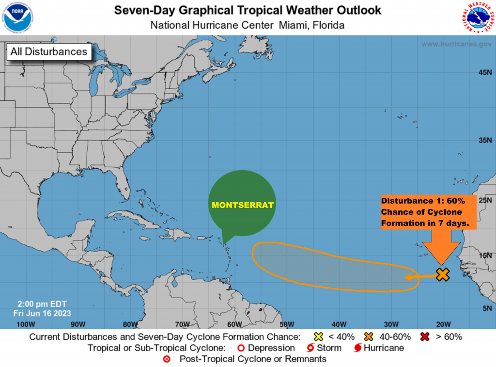
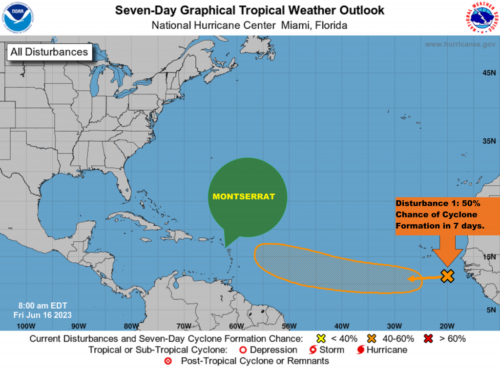
Tropical Disturbance 1 is located several hundred miles south of the Cabo Verde Islands. Environmental conditions are forecast to be favourable for some gradual development during the next several days. Therefore, a tropical depression is likely to form during the early or middle part of next week while the system moves westward, then turns northwestward or northward toward the end of the week over the eastern tropical Atlantic. The system has a 30% chance of formation in the next two days and, a 70% chance of development in the next five days.

The Disaster Management Coordination Agency, DMCA is encouraging residents and visitors to continue to monitor the DMCA and be prepared.

The Disaster Management Coordination Agency, DMCA will continue to monitor Tropical Disturbances 1 and 2, and will provide regular updates as information is released from the NHC and the Antigua and Barbuda Meteorological Services.

2PM UPDATE: Five Tropical Systems in the Atlantic; DMCA monitors the Tropical Atlantic as the season becomes more active!

Yellow Hill – Thursday, 22 September 2022 – Five (5) tropical systems are brewing in the Atlantic on Thursday afternoon, including Hurricane- Fiona, Tropical storm Gaston, Invest 98L and two other (2) tropical disturbances. The Disaster Management Coordination Agency, DMCA continues to monitor the Tropical Atlantic as the Hurricane season becomes a lot more active. At this time, none of the systems poses a threat to Montserrat, and there are no alerts, watches or warnings in effect for the island.

In its 2 PM Update, The National Hurricane Center states that INVEST 98L located in the southeastern Caribbean Sea is likely to become a tropical depression in the next day or so. The low is forecast to move west-northwestward and be over the central Caribbean Sea this weekend where conditions are expected to be conducive for additional development. Locally heavy rainfall and gusty winds are likely to affect the Windward Islands, northern Venezuela, and the ABC island chain today. The system now has with an 80% Chance of Development over the next two days and, an 90% chance of development in the next five days.

Disturbance 3 located several hundred miles west-southwest of the Cabo Verde Islands continues to produce disorganized showers and thunderstorms. Despite marginal environmental conditions, some slow development of this system is possible over the next several days while it moves slowly northwestward or northward over the tropical Atlantic. The system has a 20% chance of formation in the next two days and, a 30% chance of development in the next five days.

The Disaster Management Coordination Agency, DMCA is urging residents and visitors to pay close attention to information issued by the DMCA and be prepared, as the Atlantic Hurricane season lasts until November 30 each year, which means there’s plenty of time for more storms to brew.

The Disaster Management Coordination Agency, DMCA will continue to monitor Tropical Disturbance Invest 98L, and provide regular updates as information is released

8AM UPDATE: Two Named Storms, Invest 98L and Two Tropical Disturbances brewing in the Atlantic – Chances remain high for Invest 98L to develop into a Tropical Depression; DMCA continues to monitor its progress!

Yellow Hill – Wednesday, 21 September 2022 – Five (5) tropical systems are in the Atlantic on Thursday morning, including one (1) major hurricane- Fiona, One (1) tropical storm – Gaston, Invest 98L, and two (2) tropical disturbances for potential development. The Disaster Management Coordination Agency, DMCA continues to monitor the progress of Disturbance INVEST 98L over the southeastern Caribbean Sea likely to become a tropical depression within the next couple of days. The system now has with a 70% Chance of Development over the next two days and, an 90% chance of development in the next five days. At this time, none of the systems poses an immediate threat to Montserrat, and there are no alerts, watches or warnings in effect for the island.

In its 8 AM Update, The National Hurricane Center states that Tropical Disturbance INVEST 98L is located over the southeastern Caribbean Sea. Although upper-level winds are currently inhibiting development, the environment is forecast to gradually become more favourable in a couple of days, and a tropical depression is likely to form at that time. The disturbance is forecast to move west-northwestward across the eastern Caribbean Sea during the next day or two, and be over the central Caribbean Sea this weekend. Regardless of development, locally heavy rainfall and gusty winds are likely to affect the Windward Islands, northern Venezuela, and the ABC island chain today.

Disturbance 3 located several hundred miles west-southwest of the Cabo Verde Islands continues to produce disorganized showers and thunderstorms. Despite marginal environmental conditions, some slow development of this system is possible over the next several days while it moves slowly northwestward or northward over the tropical Atlantic. The system has a 20% chance of formation in the next two days and, a 30% chance of development in the next five days.

The Disaster Management Coordination Agency, DMCA is reminding residents and visitors to always pay close attention to information issued by the DMCA and be prepared, as the Atlantic Hurricane season lasts until November 30 each year, which means there’s plenty of time for more storms to brew. Stay Prepared!

The Disaster Management Coordination Agency, DMCA will continue to monitor Tropical Disturbance Invest 98L, and provide regular updates as information is released from the NHC.

2PM UPDATE: Five (5) Tropical Systems in the Atlantic Simultaneously – AL98 continues to show signs of organization, and is likely to become a Tropical Depression this week; DMCA continues to monitor its progress!

Yellow Hill – Wednesday, 21 September 2022 – Five (5) tropical systems are in the Atlantic simultaneously on Wednesday afternoon, including one (1) major hurricane- Fiona, One (1) tropical storm – Gaston and three (3) tropical disturbances. The Disaster Management Coordination Agency, DMCA continues to monitor the progress of Disturbance AL98 near the southern Windward Islands likely to become a tropical depression within the next couple of days. The system now has a 70% Chance of Development over the next two days and, an 90% chance of development in the next five days. At this time, none of the systems poses an immediate threat to Montserrat, and there are no alerts, watches or warnings in effect for the island.

In its 2 PM Update, The National Hurricane Center states that Tropical Disturbance AL98 near the southern Windward Islands and over adjacent waters continues to show signs of organization, and will likely become a tropical depression within the next couple of days. The disturbance is forecast to move west-northwestward across the southern Windward Islands today and then move toward the central Caribbean Sea later this week. Interests in the Windward Islands should closely monitor the progress of this system as heavy rainfall and gusty winds are affecting these islands.

Disturbance 3 is located several hundred miles west-southwest of the Cabo Verde Islands. Slow development of this system is possible over the next several days as it moves northwestward and then westward over the tropical Atlantic. The system has a 20% chance of formation in the next two days and, a 30% chance of development in the next five days.

The Disaster Management Coordination Agency, DMCA is reminding residents and visitors to always pay close attention to information issued by the DMCA and be prepared, as the Atlantic Hurricane season lasts until November 30 each year, which means there’s plenty of time for more storms to brew.

The Disaster Management Coordination Agency, DMCA will continue to monitor Tropical Disturbance AL98 (Invest 98), and provide regular updates as information is released from the NHC.

8AM UPDATE: Five (5) Tropical Systems in the Atlantic – AL98 is forecast to become a Tropical Depression this week; DMCA continues to monitor its progress!

Yellow Hill – Wednesday, 21 September 2022 – Five (5) tropical systems are in the Atlantic on Wednesday morning, including one (1) hurricane- Fiona, One (1) tropical storm – Gaston and three (3) tropical disturbances. The Disaster Management Coordination Agency, DMCA is monitoring the progress of Disturbance AL98 likely to become a tropical depression within the next couple of days. The system now has a 70% Chance of Development over the next two days and, an 90% chance of development in the next five days. The systems do not pose an immediate threat to Montserrat, and there are no alerts, watches or warnings in effect for the island.

In its 8 AM Update, The National Hurricane Center states that Tropical Disturbance AL98 couple hundred miles east of the southern Windward Islands continues to show signs of organization, and it will likely become a tropical depression within the next couple of days. The disturbance is forecast to move west-northwestward across the southern Windward Islands today and then move toward the central Caribbean Sea later this week. Interests in the Windward Islands should closely monitor the progress of this system as heavy rainfall and gusty winds are affecting these islands.

Disturbance 3 located several hundred miles west-southwest of the Cabo Verde Islands is producing disorganized shower activity. Slow development of this system is possible over the next several days as it moves northwestward and then westward over the tropical Atlantic. The system has a 20% chance of formation in the next two days and, a 30% chance of development in the next five days.

The Disaster Management Coordination Agency, DMCA is reminding residents and visitors to always pay close attention to information issued by the DMCA and be prepared, as the Atlantic Hurricane season lasts until November 30 each year, which means there’s plenty of time for more storms to brew.

The Disaster Management Coordination Agency, DMCA will continue to monitor Tropical Disturbance AL98 (Invest 98), and provide updates

11AM UPDATE: DMCA Monitors the progress of Disturbance AL98 located east of the Southern islands forecast to become a Tropical Depression in the next few days!

Yellow Hill – Tuesday, 20 September 2022 – The Disaster Management Coordination Agency, DMCA is monitoring the progress of Disturbance AL98 with a 40% Chance of Development over the next two days and, a 70% chance of development in the next five days. At this time, Disturbance AL98 poses no threat to Montserrat, and there are no alerts, watches or warnings in effect for the island.

In its 11 AM Update, The National Hurricane Center states that Tropical Disturbance AL98 several hundred miles east of the Windward Islands has become better organized this morning. Additional development is expected, and a tropical depression is likely to form within the next few days as the system moves westward to west-northwestward at 15 to 20 mph across the eastern and central Caribbean Sea. Interests in the Windward Islands should closely monitor the progress of this system as heavy rainfall and gusty winds could affect these islands beginning on Wednesday.

The Disaster Management Coordination Agency, DMCA is reminding residents and visitors to always pay close attention to information issued by the DMCA and stay prepared, as the Atlantic Hurricane season lasts until November 30 each year, which means there’s plenty of time for more storms to brew.

The Disaster Management Coordination Agency, DMCA will continue to monitor Tropical Disturbance AL98, and provide regular updates as information is released from the NHC.

8AM UPDATE: DMCA Monitors the progress of a Disturbance several hundred miles east of the Windward now with a 50% Chance of Cyclone Formation in 5 days!

Yellow Hill – Tuesday, 20 September 2022 – The Disaster Management Coordination Agency, DMCA is monitoring Tropical Disturbance 2 located several hundred miles east of the Windward Islands with a 50% Chance of Development in the next 5 days. At this time, the system poses no threat to Montserrat, and there are no alerts, watches or warnings in effect for the island.

In its 8 AM Update, The National Hurricane Center states that Tropical Disturbance 2 located several hundred miles east of the Windward Islands is producing a broad area of disorganized showers and thunderstorms while moving westward at 15-20 mph. Gradual development of this system is forecast during the next several days as the system approaches the Windward Islands, and a Tropical Depression could form by the latter part of this week as the system moves into the eastern and central Caribbean Sea. The system has a 10% chance of formation in the next two days and, a 50% chance of development in the next five days.

The Disaster Management Coordination Agency, DMCA is reminding residents and visitors to always pay close attention to information issued by the DMCA and be prepared, as the Atlantic Hurricane season lasts until November 30 each year, which means there’s plenty of time for more storms to brew.

The Disaster Management Coordination Agency, DMCA will continue to monitor Tropical Disturbance 2, and provide regular updates as information is released from the NHC.

11PM UPDATE: TROPICAL STORM FIONA HAS INCREASED IN STRENGTH – HEAVY SHOWERS ARE STILL EXPECTED

  • THAT’S ACCORDING TO THE 11’O’CLOCK STATEMENT ISSUED BY THE ANTIGUA AND BARBUDA METEOROLOGICAL SERVICES TONIGHT FRIDAY, 17 SEPTEMBER 2022.

    A TROPICAL STORM WARNING REMAINS IN EFFECT FOR MONTSERRAT.

    A TROPICAL STORM WARNING MEANS THAT TROPICAL STORM CONDITIONS ARE EXPECTED WITHIN THE SPECIFIED AREA, IN THIS CASE, TONIGHT INTO TOMORROW.

    BASED ON THE LATEST INFORMATION, MONTSERRAT IS NOW EXPERIENCING TROPICAL CYCLONE IMPACTS FROM TROPICAL STORM FIONA. HENCE, RESIDENTS SHOULD TAKE THE NECESSARY PRECAUTION.

    AT 11:00 PM ECT (0300 UTC), THE CENTER OF TROPICAL STORM FIONA WAS LOCATED NEAR LATITUDE 16.6 NORTH, LONGITUDE 62.2 WEST OR ABOUT 14 MILES EAST OF MONTSERRAT.

    FIONA IS MOVING TOWARD THE WEST NEAR 14 MPH (22 KM/H). A WEST TO WEST-NORTHWEST MOTION WITH A DECREASE IN FORWARD SPEED IS EXPECTED THROUGH SUNDAY NIGHT. A TURN TOWARDS THE NORTHWEST IS EXPECTED ON MONDAY.

    MAXIMUM SUSTAINED WINDS ARE NEAR TO 60 MPH (95 KM/H) WITH HIGHER GUSTS. GRADUAL STRENGTHENING IS FORECAST DURING THE NEXT FEW DAYS. TROPICAL STORM-FORCE WINDS EXTEND OUTWARD UP TO 140 MILES (220 KM) FROM THE CENTER.

    THE ESTIMATED MINIMUM CENTRAL PRESSURE IS 1002 MB (29.59 INCHES).

    BASED ON THE LATEST FORECAST TRACK INFORMATION, TROPICAL STORM FIONA IS NOW ON THE DOORSTEP OF MONTSERRAT. THIS MEANS THAT MONTSERRAT WILL CONTINUE TO BE EXPOSED TO TROPICAL STORM FORCE WINDS.

    CURRENT SPECIFIC IMPACTS INCLUDE:

    WINDS: 40 TO 50 MPH SUSTAINED WINDS WITH POSSIBLE HIGHER GUSTS TO 70 MPH ARE LIKELY. THESE WINDY CONDITIONS COULD PRODUCE FLYING DEBRIS FROM SMALL OBJECTS AND DAMAGE TO WEAK INFRASTRUCTURE.

    RAINFALL: RAINFALL ACCUMULATIONS OF 1 TO 4 INCHES ARE POSSIBLE OVER THE NEXT 24 HOURS. THIS COULD PRODUCE FLASH FLOODING IN LOW LYING AND FLOOD PRONE AREAS AS WELL AS MUDSLIDES. A FLASH FLOOD WATCH IS NOW IN EFFECT UNTIL SATURDAY 8AM.

    SEAS: SEAS REACHING BETWEEN 9 TO 15 FEET MAINLY IN STORM SURGE, COULD PRODUCE BATTERING WAVES AND RIP CURRENTS. AS A RESULT MARINERS AND BEACHGOERS SHOULD STAY IN PORT AND AVOID THE BEACHES.
  • RESIDENTS IN MONTSERRAT SHOULD CONTINUE TO CLOSELY MONITOR THE PROGRESS OF FIONA.

  • THE NEXT ADVISORY WILL BE AT 2 AM ECT.

    FORECASTER LETITIA HUMPHREYS

9PM UPDATE: BASED ON THE LATEST FORECAST TRACK INFORMATION, TROPICAL STORM FIONA HAS SHIFTED CLOSER TO MONTSERRAT. THIS MEANS THAT MONTSERRAT WILL BE EXPOSED TO TROPICAL STORM FORCE WINDS.

ACCORDING TO THE 9PM UPDATE ISSUED BY THE ANTIGUA AND BARBUDA METEOROLOGICAL SERVICES, TROPICAL STORM FIONA IS MOVING CLOSER AND CLOSER AND HEAVY SHOWERS ARE EXPECTED TONIGHT.

A TROPICAL STORM WARNING REMAINS IN EFFECT FOR MONTSERRAT

.A TROPICAL STORM WARNING MEANS THAT TROPICAL STORM CONDITIONS ARE EXPECTED WITHIN THE SPECIFIED AREA, IN THIS CASE, TONIGHT INTO TOMORROW.

BASED ON THE LATEST INFORMATION, MONTSERRAT IS NOW EXPERIENCING TROPICAL CYCLONE IMPACTS FROM TROPICAL STORM FIONA. HENCE, RESIDENTS SHOULD TAKE THE NECESSARY PRECAUTION.

AT 8:00 PM, THE CENTER OF TROPICAL STORM FIONA WAS LOCATED NEAR LATITUDE 16.5 NORTH, LONGITUDE 61.5 WEST OR ABOUT 51 MILES EAST-SOUTHEAST MONTSERRAT.ON THE FORECAST TRACK, THE CENTER OF FIONA IS EXPECTED TO MOVE ACROSS THE LEEWARD ISLANDS TONIGHT.

FIONA IS MOVING TOWARD THE WEST NEAR 15 MPH (24 KM/H). A WEST TO WEST-NORTHWEST MOTION WITH A DECREASE IN FORWARDING SPEED IS EXPECTED THROUGH EARLY MONDAY.

MAXIMUM SUSTAINED WINDS ARE NEAR TO 50 MPH (85 KM/H) WITH HIGHER GUSTS. GRADUAL STRENGTHENING IS FORECAST DURING THE NEXT FEW DAYS.

TROPICAL STORM-FORCE WINDS EXTEND OUTWARD UP TO 140 MILES (220 KM) FROM THE CENTER AND A WIND GUST OF 44 MPH WAS RECENTLY REPORTED AT V.C.BIRD INTERNATIONAL AIRPORT IN ANTIGUA.

THE ESTIMATED MINIMUM CENTRAL PRESSURE IS 1002 MB (29.59 INCHES).

BASED ON THE LATEST FORECAST TRACK INFORMATION, TROPICAL STORM FIONA HAS SHIFTED CLOSER TO MONTSERRAT. THIS MEANS THAT MONTSERRAT WILL BE EXPOSED TO TROPICAL STORM FORCE WINDS. THESE ARE WINDS OF THE ORDER OF 39 MPH. MORE SPECIFIC IMPACTS INCLUDE:

WINDS: 30 TO 40 MPH SUSTAINED WINDS WITH POSSIBLE HIGHER GUSTS TO 55 MPH ARE LIKELY. THESE WINDY CONDITIONS COULD PRODUCE FLYING DEBRIS FROM SMALL OBJECTS AND DAMAGE TO WEAK INFRASTRUCTURE.

RAINFALL: RAINFALL ACCUMULATIONS OF 1 TO 4 INCHES ARE POSSIBLE OVER THE NEXT 24 HOURS. THIS COULD PRODUCE FLASH FLOODING IN LOW-LYING AND FLOOD-PRONE AREAS AS WELL AS MUDSLIDES. A FLASH FLOOD WATCH IS NOW IN EFFECT UNTIL SATURDAY 8AM.

SEAS: SEAS REACHING BETWEEN 9 TO 15 FEET MAINLY IN STORM SURGE, COULD PRODUCE BATTERING WAVES AND RIP CURRENTS. AS A RESULT MARINERS AND BEACHGOERS SHOULD STAY IN PORT AND AVOID THE BEACHES.

RESIDENTS IN MONTSERRAT SHOULD CONTINUE TO CLOSELY MONITOR THE PROGRESS OF FIONA.

THE NEXT COMPLETE ADVISORY WILL BE AT 11 PM.

FORECASTER LETITIA HUMPHREYS

5PM Update: Tropical Storm Conditions beginning to affect portions of the Leeward Islands – Be vigilant and stay safe!

Tropical Storm Warning remains in effect for Montserrat!

At 5PM, The National Hurricane says that the center of Tropical Storm Fiona was located near latitude 16.4 North, longitude 61.1 West. Fiona is moving toward the west near 15 mph (24 km/h). A westward to west-northwestward motion with a decrease in forward speed is expected through early Monday. A turn toward the northwest is forecast later on Monday. On the forecast track, the center of Fiona is expected to move across the Leeward Islands during the next few hours, near or just south of the Virgin Islands and Puerto Rico Saturday into Sunday, and approach the southern or eastern coast of the Dominican Republic Sunday afternoon. Fiona is forecast to move across the Dominican Republic Sunday night and Monday.

Maximum sustained winds are near 50 mph (85 km/h) with higher gusts. Gradual strengthening is forecast during the next 48 hours or so before the center of Fiona reaches the Dominican Republic on Sunday.

Tropical-storm-force winds extend outward up to 140 miles (220 km) from the center.

Observations from Guadeloupe indicate that the minimum central pressure is 1004 mb (29.65 inches).

The Disaster Management Coordination Agency, DMCA is urging residents and visitors to continue to monitor the DMCA, and hope for the best but prepare for the worst.