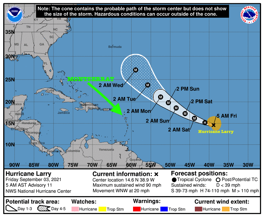
Swells generated by Hurricane Larry are forecast to reach the Lesser Antilles which Includes Montserrat on Sunday. These Swells are Likely to Cause Life-Threatening Surf and Rip Current Conditions.
The National Hurricane Center said Hurricane Larry continues to gradually become better organized with winds of 90 mph winds. It states that Larry is expected to become a major hurricane by Friday night.
At 5 AM, the center of Hurricane Larry was located near latitude 14.6 North, longitude 38.9 West. Larry is moving toward the west-northwest near 20 mph (31 km/h) and this motion is expected during the next few days. A turn to the northwest is forecast by early next week.Maximum sustained winds have increased to near 90 mph (150 km/h) with higher gusts. Additional strengthening is forecast during the next few days, and Larry could become a major hurricane by tonight.
Hurricane-force winds extend outward up to 25 miles (35 km) from the center and tropical-storm-force winds extend outward up to 150 miles.

The estimated minimum central pressure is 982 mb (29.00 inches).
HAZARDS AFFECTING LAND
———————-
SURF: Swells generated by Larry are expected to reach the Lesser Antilles on Sunday. These swells are likely to cause life-threatening surf and rip current conditions.
Continue to check the DMCA Facebook, Twitter and Instagram pages and our website http://dmca.gov.ms for daily updates.
The Disaster Management Coordination Agency, DMCA will continue to monitor Tropical Storm Larry and provide regular updates accordingly.
