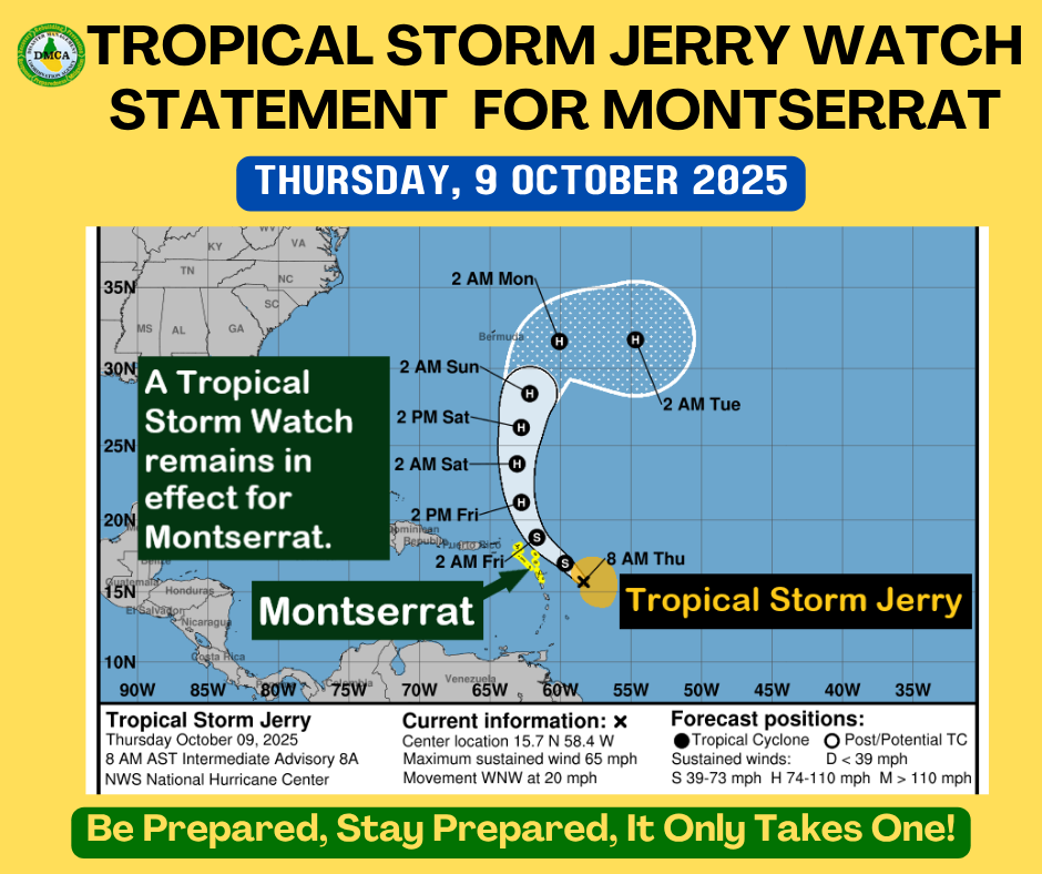
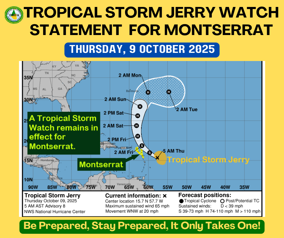
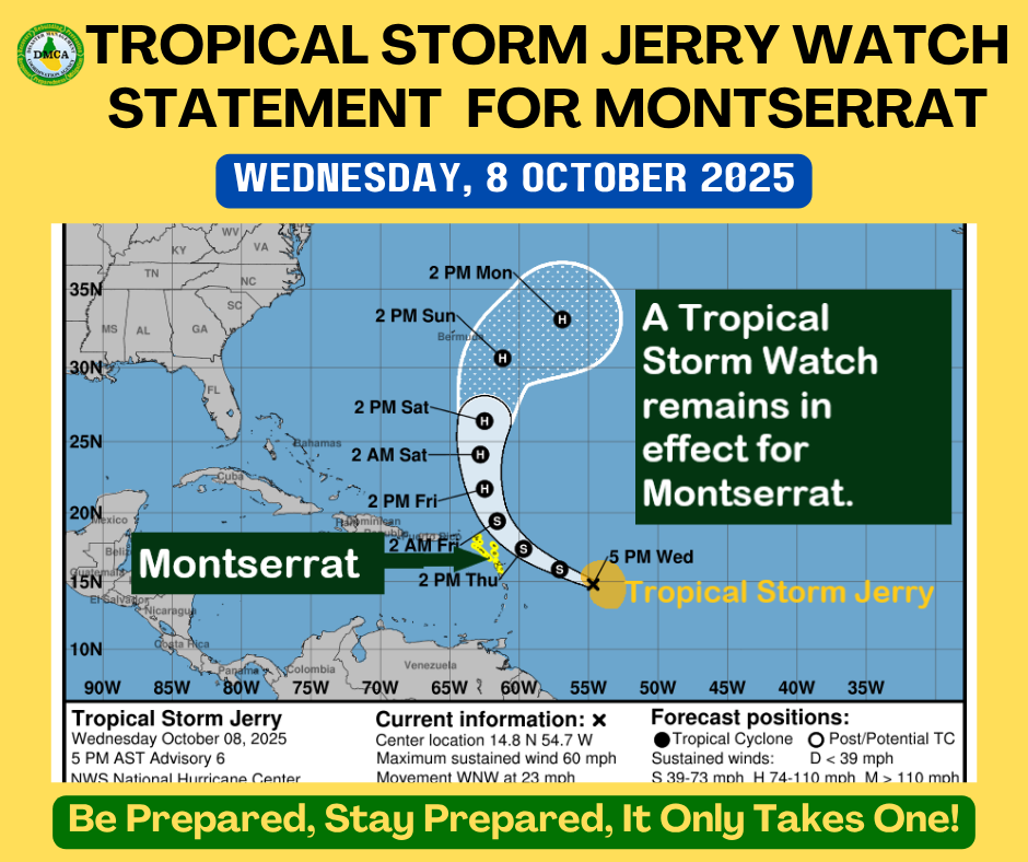
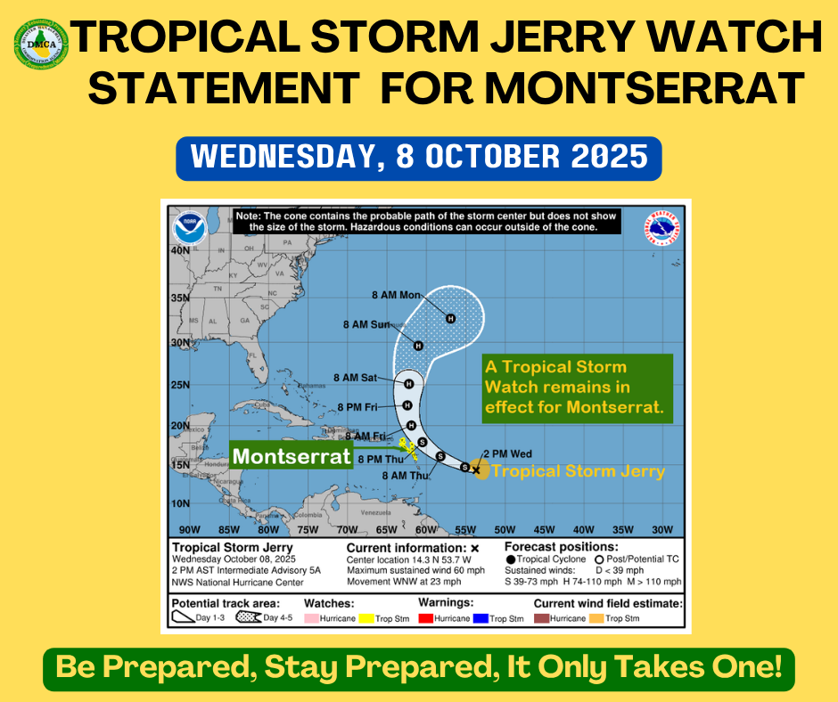
TROPICAL STORM JERRY (POTENTIAL TROPICAL CYCLONE) WATCH STATEMENT

ANTIGUA AND BARBUDA METEOROLOGICAL SERVICES
11:00 PM ECT | Tuesday, 7 October 2025

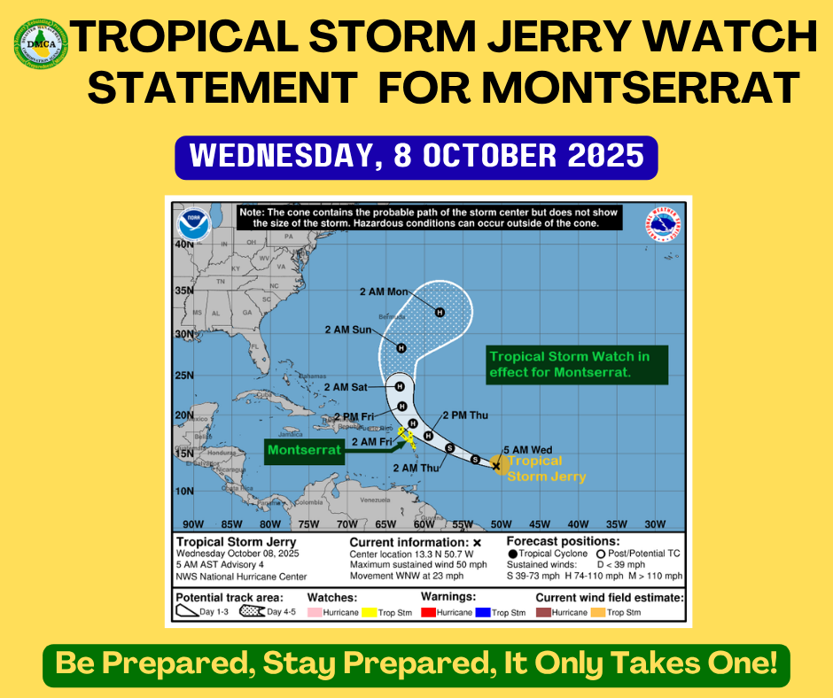
…TROPICAL STORM JERRY MOVING QUICKLY TOWARD THE ISLANDS…

A Tropical Storm Watch is now in effect for Montserrat.

A Tropical Storm Watch means that tropical-storm or developing tropical-storm conditions pose a possible threat to the specified area within 48 hours. Residents should begin to implement their hurricane preparedness plans.

At 11:00 PM ECT (0300 UTC), the centre of Tropical Storm Jerry was located near latitude 12.8° North, longitude 48.7° West, or about 1,030 miles (1,655 km) east-southeast of the northern Leeward Islands.

Jerry is moving toward the west-northwest near 23 mph (37 km/h). A decrease in forward speed and a turn toward the west-northwest are expected over the next couple of days.

Maximum sustained winds are 50 mph (85 km/h), with higher gusts. Little change in intensity is forecast tonight, but gradual strengthening is possible, and Jerry may become a hurricane within the next day or two.

Tropical-storm-force winds extend outward up to 140 miles (220 km) from the centre.
The estimated minimum central pressure is 1003 mb (29.62 inches).

Based on the latest observations and analysis, Jerry is projected to pass over or very near to the northern Leeward Islands late Thursday into Friday, possibly as a hurricane.

Jerry will be monitored closely, and information on potential impacts will be communicated as the system moves closer to the islands over the coming days.

?? All residents are urged to monitor the movement of Jerry closely and take action to protect life and property.
A Tropical Storm Warning is likely within the next 24 hours.

? Repeating the 11:00 PM ECT position:

Location: 12.8° N, 48.7° W

Movement: West-northwest near 23 mph (37 km/h)

Maximum sustained winds: 50 mph (85 km/h)

Minimum central pressure: 1003 mb (29.62 inches)

The next advisory will be issued at 5:00 AM ECT.

Forecaster: Trecy Spencer-Lake

TROPICAL STORM JERRY ALERT STATEMENT

ANTIGUA AND BARBUDA METEOROLOGICAL SERVICES
5:00 PM ECT | Tuesday, 7 October 2025

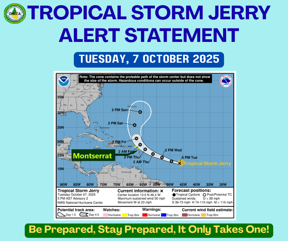
…TROPICAL STORM JERRY FORMS OVER THE CENTRAL TROPICAL ATLANTIC…

At 5:00 PM ECT (2100 UTC), the centre of Tropical Storm Jerry was located near latitude 12.0° North, longitude 46.4° West, or about 1,119 miles east-southeast of the northern Leeward Islands.

Jerry is moving toward the west near 23 mph, and this general motion is expected to continue during the next 24 hours.

Maximum sustained winds are near 50 mph, with higher gusts. Gradual strengthening is possible over the next day or two.

Tropical-storm-force winds extend outward up to 85 miles from the centre.

The estimated minimum central pressure is 1003 mb (29.62 inches).

On its present track, the system is expected to be near the Leeward Islands by Thursday evening into Friday. As a result, a Tropical Storm Watch may be required for some islands within the next 48 hours.

Residents should complete their hurricane preparedness plans and be ready to implement them if necessary.

?? All residents are urged to closely monitor the movement of Tropical Storm Jerry.

The next update will be issued at 11:00 PM ECT.

Forecaster: Cecil Matthew

Tropical Cyclone Information Statement Antigua and Barbuda Meteorological Service 2:00 PM ECT Monday, October 6, 2025

…Tropical cyclone expected to form — be prepared and monitor closely…

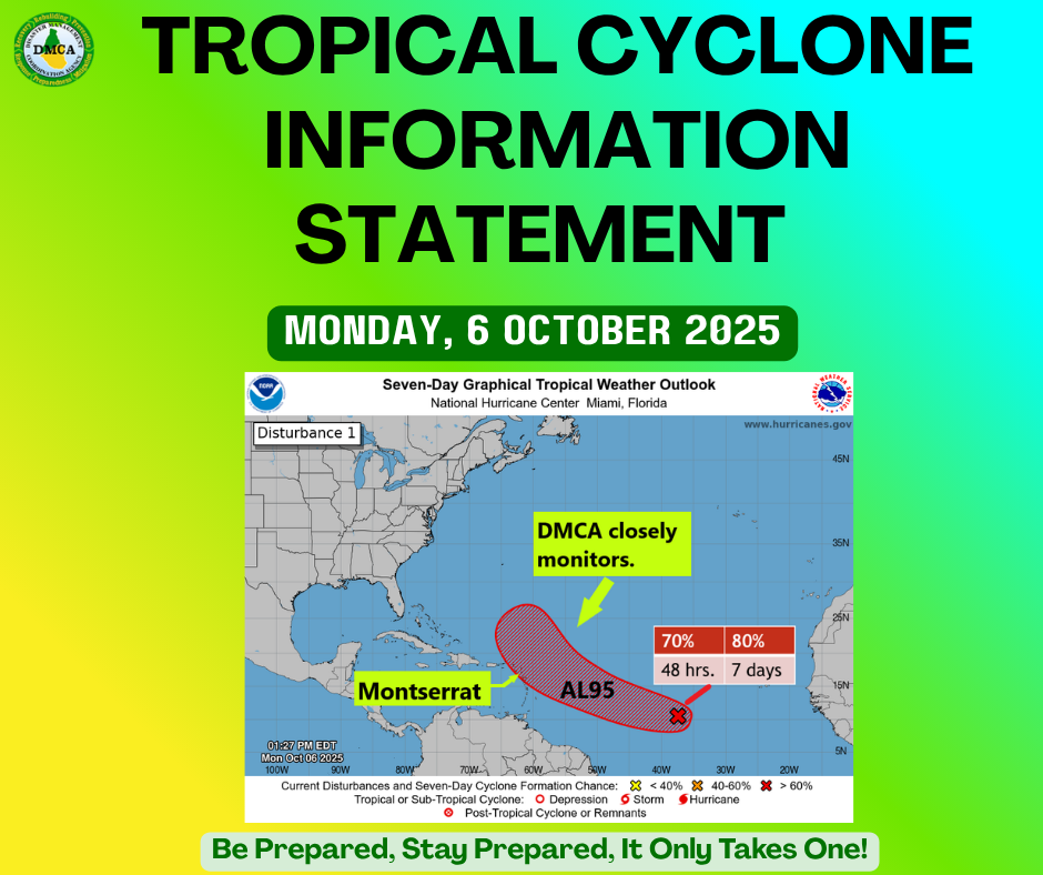
The Antigua and Barbuda Meteorological Service continues to closely monitor Tropical Disturbance AL95, located over the central tropical North Atlantic Ocean. The system has a high chance of becoming a tropical depression or storm within the next 48 hours, as it moves generally toward the region, particularly the Leeward Islands.

Although it is still early, confidence is increasing that AL95 could strengthen into a hurricane within four days. However, it remains uncertain whether the eventual tropical cyclone will directly impact the area. At this time, most forecast models — including the reliable European model — show a storm or hurricane passing just north of the Leeward Islands around Thursday or Friday.

Residents and visitors of Montserrat and the rest of the Leeward Islands should continue to monitor this system closely. To be safe, everyone is reminded to remain prepared for the remainder of the hurricane season.

At 2 PM, Tropical Disturbance AL95 was centered about 1,716 miles east-southeast of Antigua and Barbuda (and the rest of the Leeward Islands), moving west at around 18 mph.
Maximum sustained winds are near 30 mph, with higher gusts.
Formation chance through 48 hours is 70 percent, and formation chance through seven days is 80 percent.
This means development is likely within the next two days and expected within the next week.

Please note that no tropical cyclone alerts, watches, or warnings are in effect at this time, but these could be required within the next 48 hours.

The next update will be issued around 2 PM tomorrow, or sooner if required.

Forecaster: Dale Destin

? Tropical Weather Update – Tuesday, 23 September 2025 | 8 AM

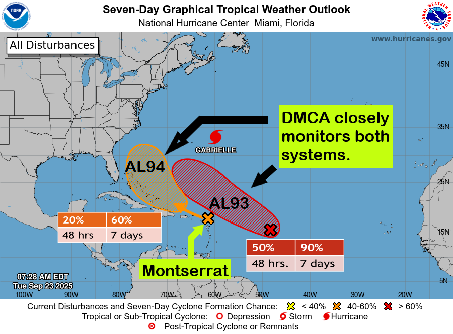
The Disaster Management Coordination Agency (DMCA) is closely monitoring two tropical disturbances in the Atlantic.

? Invest 94L (Orange), located just under 1,000 miles east of the Lesser Antilles, is forecast to bring heavy showers, thunderstorms, and gusty winds across Montserrat today.
? Rainfall accumulations of 1–3 inches are expected, and a flash flood watch is in effect for low-lying and flood-prone areas across the island.

? Formation Chances:
• Next 48 hours: Near 20%
• Next 7 days: Medium (60%)

? Invest 93L (Red), located about 1,000 miles east of the islands, is likely to develop into a tropical depression by the latter half of this week as it moves west-northwest to northwest into the western tropical Atlantic. At this time, the system poses no immediate threat to Montserrat.

? Formation Chances:
• Next 48 hours: Medium (50%)
• Next 7 days: High (90%)

Residents are urged to remain vigilant, stay informed, and monitor official DMCA updates.

? The DMCA will continue to monitor these systems closely and provide timely updates.

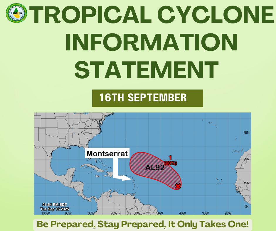
Tropical Cyclone Information Statement Antigua and Barbuda Meteorological Services Tuesday, September 16, 2025

…Tropical cyclone formation likely—Montserrat residents should remain attentive…

The Antigua and Barbuda Meteorological Service continues to monitor AL92, a broad area of low pressure currently moving through the central tropical Atlantic. The system has a high chance (90%) of becoming a tropical depression or tropical storm within the next 48 hours, as it moves west-northwest to northwest at 10–15 mph.

Forecast models currently suggest that, if AL92 develops into a tropical cyclone, it is likely to pass well to the northeast of the region. However, its exact path and timing remain uncertain.

To ensure safety, residents of Montserrat and the surrounding islands are urged to:
? Stay informed—continue monitoring official updates.
? Remain prepared—review hurricane plans and supplies as the season continues.

As of 2:00 PM, AL92 was located roughly midway between the Windward Islands and the Cabo Verde Islands, with winds near 30 mph and higher gusts.

?? No tropical cyclone alerts, watches, or warnings are currently in effect for Montserrat at this time.

Forecaster: Jaleel Jacobs

Tropical Weather Update – Tuesday, 16 September 2025 | 8 AM

The Disaster Management Coordination Agency (DMCA) is monitoring two disturbances in the Atlantic.

? AL92 – Located about midway between the Windward Islands and the coast of West Africa, this system has become better organized since yesterday. Additional development is expected, and a tropical depression or storm is likely to form within the next day or two as it moves west-northwestward or northwestward at 10–15 mph over the central tropical Atlantic.

? Formation Chances:
• Next 48 hours: High (90%)
• Next 7 days: High (90%)

? Second Disturbance – A new tropical wave emerging off the African coast. It remains far out in the Atlantic and currently has only a 20% chance of development within 7 days (near 0% in the next 48 hours).

At this time, neither system poses an immediate threat to Montserrat. However, residents are urged to stay informed, remain vigilant, and be prepared.

The DMCA will continue to monitor both systems closely and provide timely updates.

Tropical Cyclone Information Statement

Antigua and Barbuda Meteorological Service
10:40 a.m. Friday, September 5, 2025

…Tropical cyclone expected to form – Residents and visitors should monitor closely…

The Antigua and Barbuda Meteorological Service continues to closely monitor the progress of Tropical Disturbance AL91, located over the central tropical North Atlantic Ocean. The system is expected to become a tropical depression or storm early next week as it moves in the general direction of the Caribbean.

At this stage, it is still unclear when AL91 will form or whether it will impact the region. The system currently appears weaker in satellite imagery compared to yesterday, and some reliable models have reduced its potential for formation. However, environmental conditions remain generally favourable for further development. The risk of hazards from this disturbance is low at this time.

Residents of Montserrat should remain vigilant for potential hazardous weather and continue monitoring the progress of this system. To be safe, residents are reminded to stay prepared for the remainder of the hurricane season.

At 8 a.m., Tropical Disturbance AL91 was centred about 1,743 miles east-southeast of Antigua and Barbuda and the Leeward Islands, moving west at around 9 mph.

Maximum sustained winds remain near 25 mph with higher gusts. Formation chance through 48 hours is medium (60%), and formation chance over seven days is high (90%). This means development in the next 48 hours is more likely than not, and development over the next week is expected.

Please note that there are no tropical cyclone alerts, watches, or warnings in effect for the area at this time; however, an alert will likely be required within the next 24 hours.

The next update will be issued around 2 p.m. tomorrow, or sooner if required.

Forecaster: Dale Destin

Tropical Weather Update – Friday, 5 September 2025

The Disaster Management Coordination Agency (DMCA) continues to monitor a tropical disturbance over the eastern tropical North Atlantic, now officially classified as Invest 91L (AL91). The system has a medium (60%) chance of development within 48 hours and a high (90%) likelihood over the next 7 days of becoming a tropical depression or storm.


AL91 has become better organized and is currently moving slowly westward at around 5–10 mph. It could be near the Lesser Antilles by the middle to latter part of next week.


At this early stage, it remains uncertain when the system will develop or whether it could impact Montserrat. Residents and visitors are urged to closely monitor its progress, assess their risk to hurricane hazards, review preparedness plans, and stay ready.


? Formation Chances:
Next 48 hours: Medium (60%)
Next 7 days: High (90%)
? This means short-term development is possible, but the likelihood increases significantly over the next week.


? There are no tropical cyclone alerts, watches, or warnings in effect for Montserrat at this time.


? The DMCA will continue to monitor this system closely and provide timely updates.

Tropical Cyclone Information Statement #3 issued by the Antigua and Barbuda Meteorological Service on Tropical Disturbance 1 – Thursday, 4 September 2025 @ 10:00 AM

The Antigua and Barbuda Meteorological Service continues to monitor the progress of an active tropical wave over the eastern tropical North Atlantic Ocean. The system is now expected to become a tropical depression or storm this weekend or early next week, as it moves in the general direction of the region.

At this stage, it remains unclear exactly when the system will develop or whether it will directly impact the region. However, over the last 12 hours, the wave has become better organized and is looking the most impressive to date. Residents in Montserrat are therefore advised to continue monitoring its progress. To be safe, residents are reminded to remain prepared for the remainder of the hurricane season.

At 8:00 a.m., the tropical wave of interest was centered about 1,916 miles east-southeast of Antigua and Barbuda and the Leeward Islands, moving west at around 9 mph.

Maximum sustained winds remain near 25 mph with higher gusts. Formation chance through 48 hours is medium at 50 percent, and formation chance over seven days is high at 80 percent. This means development in the next 48 hours is equally likely as not, but highly likely or expected within the next week.

Please note that there are no tropical cyclone alerts, watches, or warnings in effect for the area at this time, but these may be required in a couple of days.

The next update will be issued around 2:00 p.m. tomorrow, or sooner if required.

Forecaster: Dale Destin

? Tropical Cyclone Information Statement #2 – Tropical Disturbance 1

Issued: Wednesday, September 3, 2025 – 9:30 a.m.

The Antigua and Barbuda Meteorological Service continues to monitor the progress of an active tropical wave over the eastern tropical North Atlantic. The system has a high chance of developing into a tropical depression or storm later this week or the weekend as it moves generally westward toward the region.

At this early stage, it remains uncertain if or when the system will develop or whether it will impact the region. Residents and visitors in Montserrat are advised to continue monitoring its progress. ??To be safe, residents are reminded to remain prepared for the remainder of the hurricane season.

At 8 am, the tropical wave of interest was centred about 2130 miles east-southeast of Antigua and Barbuda and the Leeward Islands, moving west at around 12 mph.

Based on ASCAT Data, maximum sustained winds remain near 25 mph, with higher gusts. Formation chance through 48 hours is low at 30 percent, and formation chance over seven days is high at 70 percent. This means that development in the next 48 hours is unlikely, but there is a significant chance of development over the next seven days.

? There are currently no tropical cyclone alerts, watches, or warnings in effect for Montserrat.

May be an image of map and text that says 'NORA All Disturbances Seven-Day Graphical Tropical Weather Outlook National Hurricane Center Miami, Florida ERTHER www.hurricanes.gov 45N 35 DMCA Monitors Disturbance #1 MNI 15N 30% 07:21 AM AMEDT EDT Wed Sep 03 2025 48 48hrs. hrs. 100W 90W 80W 70W 60W 40W 30W Current Disturbances and Seven-Day Cyclone Formation Chance: x <40% 40-60% Tropical or Sub- Sub-Tropical Cyclone: O Depression Storm Hurricane Post-Tropical Tropical Cyclone or Remnants 70% 7 days 20W 60% 5N'

? The next update will be issued by 2:00 p.m. tomorrow, or sooner if required.

Forecaster: Dale Destin