For the full situation report please click HERE: http://dmca.gov.ms/wp-content/uploads/2023/06/Information-Note-1-Tropical-Storm-Bret-June-22-2023.pdf
11 AM UPDATE: A TROPICAL CYCLONE ALERT REMAINS IN EFFECT FOR MONTSERRAT – ON ITS PRESENT TRACK, BRET IS FORECAST TO MOVE OVER THE WINDWARD ISLANDS THIS EVENING AND TONIGHT, WELL SOUTH OF AND AT A SAFE DISTANCE FROM MONTSERRAT. NO SPECIFIC ACTION IS REQUIRED OF RESIDENTS AT THIS TIME OTHER THAN TO KEEP MONITORING THE PROGRESS OF TROPICAL STORM BRET!
THAT’S ACCORDING TO THE 5 AM TROPICAL ALERT STATEMENT ISSUED BY THE ANTIGUA AND BARBUDA METEOROLOGICAL SERVICES ON THURSDAY, 22 JUNE 2023.
IT STATES THAT BRET IS NEARING THE WINDWARD ISLANDS AND IS EXPECTED TO BRING STRONG WINDS AND HEAVY RAIN TO A PORTION OF THE WINDWARD ISLANDS LATER TODAY AND TONIGHT.
AT 11 AM, THE CENTRE OF TROPICAL STORM BRET WAS LOCATED NEAR LATITUDE 13.8 NORTH, LONGITUDE 57.7 WEST OR ABOUT 309 MILES SOUTHEAST OF THE LEEWARD ISLANDS AND 484 MILES SOUTHEAST OF THE BRITISH VIRGIN ISLANDS.
TROPICAL STORM BRET IS MOVING TOWARD THE WEST NEAR 14 MILES PER HOUR AND THIS GENERAL MOTION IS EXPECTED TO CONTINUE DURING THE NEXT FEW DAYS.
MAXIMUM SUSTAINED WINDS ARE NEAR 70 MPH WITH HIGHER GUSTS. LITTLE CHANGE IN INTENSITY IS FORECAST TODAY AND SOME WEAKENING IS ANTICIPATED TO BEGIN TONIGHT OR FRIDAY AFTER BRET PASSES THE ISLANDS.
TROPICAL STORM FORCE WINDS EXTEND UP TO 115 MILES FROM THE CENTRE.
THE ESTIMATED MINIMUM CENTRAL PRESSURE IS 999 MB OR 29.50 INCHES.

THE NEXT ADVISORY WILL BE AT 5 PM TODAY.
FORECASTER LORNE SALMON
Urgent – Marine Weather Message – Antigua and Barbuda Met Services issues a High Surf Advisory for Montserrat today, Thursday, 22 June 2023.
According to the Antigua and Barbuda Meteorological Services Moderate long-period swells are expected to reach the area and affect mainly the eastern coastlines. The threat level to the life, livelihood, property and infrastructure of those using the affected coastlines will rise to moderate. These swells could cause life-threatening surfs and rip currents on affected coastlines. A high surf advisory means that dangerous surfs of 2 to 3 metres or 6 to 10 feet will affect some coastlines in the advisory area, producing hazardous conditions.
Location: Reefs and exposed northern coastlines with relatively shallow, gently to moderately sloping, nearshore areas.
Timing: Thursday morning until Friday morning.
Synopsis: Seas (significant wave heights): 2.1 to 3.7 metres (7 to 12 feet), occasionally or locally reaching near 4.6 metres (15 feet). Swell period: 10 to 14 seconds. Swells: East at 1.5 to 2.5 metres (5 to 8 feet) and occasionally higher.
Surfs (breaking swells): Over 2 metres (over 6 feet). These conditions are conducive for dangerous rip currents. Please note that surfs could be as much as twice the height of swells, depending on the bathymetry of the nearshore areas.
Coastal flooding: High tides combined with onshore wind and swell actions could result in localized coastal flooding and beach erosion.
Potential Impacts: Loss of life–strong currents that can carry even the strongest swimmers out to sea; injuries to beachgoers; beach erosion; sea water splashing onto low-lying coastal roads; beach closures; localized disruptions to marine recreation and businesses; financial losses; damage to coral reefs; saltwater intrusion and disruptions to potable water from desalination. High surfs can knock spectators off exposed rocks and jetties.
Precautionary: Beachgoers, especially to the mainly affected coastlines, should be extremely cautious; bathe only where lifeguards are present or on the sheltered, less affected beaches, mainly to the west. Extreme caution is also required by those using the affected non-beach or rocky coastlines.
Rip currents are powerful channels of water flowing quickly away from shore, which occur most often at low spots or breaks in the sandbar and near structures such as groins, jetties and piers. If caught in a rip current, relax and float.
Don`t swim against the current. If able, swim in a direction following the shoreline. If unable to escape, face the shore and call or wave for help.
Forecaster: Dale Destin
5 AM UPDATE: Tropical Depression 4 forms in the Central Atlantic on the heels of Tropical Storm Bret – DMCA Continues to monitor both systems closely.
Yellow Hill – Thursday, 22 June 2023 – Tropical Depression 4 is not an immediate threat to Montserrat at this time, and no watches or warnings have been issued for the island. The Disaster Management Coordination Agency (DMCA) continues to monitor the progress of the system closely and will provide regular updates.
As of 5 AM, the National Hurricane Center Advisory says the center of Tropical Depression Four was located near latitude 10.9 North, longitude 41.1 West. The depression is moving toward the west near 12 mph (19 km/h), and this motion is expected to increase with a turn toward the northwest during the next few days. On the forecast track, the depression is expected to remain east of the northern Leeward Islands through the
weekend.
Maximum sustained winds are estimated to be near 35 mph (55 km/h) with higher gusts. Some strengthening is forecast during the next few days, and the depression is expected to become a tropical storm in a day or so.
The estimated minimum central pressure is 1007 mb (29.74 inches).

The Disaster Management Coordination Agency (DMCA) is urging residents and visitors to continue to monitor the DMCA, review their hurricane plans, assess their risks, complete their hurricane preparations, and be prepared.
Be Prepared, Stay Prepared, It Only Takes One!
5 AM UPDATE: A TROPICAL CYCLONE ALERT REMAINS IN EFFECT FOR MONTSERRAT – TROPICAL STORM BRET POISED TO BRING STRONG WINDS AND HEAVY RAINS TO MONTSERRAT LATER TODAY AND TONIGHT – RESIDENTS SHOULD CONTINUE TO MONITOR THE PROGRESS OF TROPICAL STORM BRET.
ACCORDING TO THE 5 AM TROPICAL ALERT STATEMENT ISSUED BY THE ANTIGUA AND BARBUDA METEOROLOGICAL SERVICES ON THURSDAY, 22 JUNE 2023, ON ITS PRESENT TRACK, BRET IS FORECAST TO MOVE OVER THE WINDWARD ISLANDS ON THURSDAY WELL SOUTH OF AND AT A SAFE DISTANCE FROM MONTSERRAT. NO SPECIFIC ACTION IS REQUIRED OF RESIDENTS AT THIS TIME OTHER THAN TO KEEP MONITORING THE PROGRESS OF TROPICAL STORM BRET.
AT 5 AM, THE CENTER OF TROPICAL STORM BRET WAS LOCATED NEAR LATITUDE 13.7 NORTH, LONGITUDE 56.6 WEST OR ABOUT 363 MILES SOUTHEAST OF THE LEEWARD ISLANDS.
BRET IS MOVING TOWARDS THE WEST NEAR 15 MILES PER HOUR AND THIS GENERAL MOTION WITH AN INCREASE IN FORWARD SPEED IS EXPECTED TO CONTINUE DURING THE NEXT FEW DAYS.
MAXIMUM SUSTAINED WINDS ARE NEAR 70 MPH WITH HIGHER GUSTS. LITTLE CHANGE IN STRENGTH IS FORECAST DURING THE NEXT DAY OR SO WHILE BRET APPROACHES THE LESSER ANTILLES. WEAKENING IS ANTICIPATED TO BEGIN THURSDAY NIGHT OR FRIDAY AFTER BRET PASSES THE LESSER ANTILLES, AND THE SYSTEM IS LIKELY TO DISSIPATE OVER THE CENTRAL CARIBBEAN SEA BY SATURDAY.
TROPICAL STORM FORCE WINDS EXTEND UP TO 115 MILES FROM THE CENTER.
THE ESTIMATED MINIMUM CENTRAL PRESSURE IS 996 MB OR 29.42 INCHES.

THE NEXT ADVISORY WILL BE AT 11 AM.
FORECASTER CECIL MATTHEW
5 PM UPDATE: A TROPICAL CYCLONE ALERT REMAINS IN EFFECT FOR MONTSERRAT – ON ITS PRESENT TRACK, TROPICAL STORM BRET IS FORECAST TO PASS WELL SOUTH OF AND AT A SAFE DISTANCE FROM MONTSERRAT OVER ON THURSDAY AND FRIDAY. NO SPECIFIC ACTION IS REQUIRED OF RESIDENTS AT THIS TIME OTHER THAN TO KEEP MONITORING THE PROGRESS OF BRET!
ACCORDING TO THE 5 PM TROPICAL ALERT STATEMENT ISSUED BY THE ANTIGUA AND BARBUDA METEOROLOGICAL SERVICES ON WEDNESDAY, 21 JUNE 2023, TROPICAL STORM BRET CONTINUES TO MOVE WESTWARDS.
AT 5 PM, THE CENTER OF TROPICAL STORM BRET WAS LOCATED NEAR LATITUDE 13.3 NORTH, LONGITUDE 53.9 WEST OR ABOUT 586 MILES SOUTHEAST OF THE LEEWARD ISLANDS AND BRITISH VIRGIN ISLANDS.
BRET IS MOVING TOWARD THE WEST NEAR 15 MILES PER HOUR AND THIS GENERAL MOTION WITH AN INCREASE IN FORWARD SPEED IS EXPECTED TO CONTINUE DURING THE NEXT FEW DAYS.
MAXIMUM SUSTAINED WINDS ARE NEAR 65 MPH WITH HIGHER GUSTS. LITTLE CHANGE IN STRENGTH IS FORECAST DURING THE NEXT DAY OR SO WHILE BRET APPROACHES THE LESSER ANTILLES. WEAKENING IS ANTICIPATED TO BEGIN THURSDAY NIGHT OR FRIDAY AFTER BRET PASSES MONTSERRAT, AND THE SYSTEM IS LIKELY TO DISSIPATE OVER THE CENTRAL CARIBBEAN SEA BY SATURDAY.
TROPICAL STORM FORCE WINDS EXTEND UP TO 105 MILES FROM THE CENTER.
THE ESTIMATED MINIMUM CENTRAL PRESSURE IS 1000 MB OR 29.53.
REPEATING THE 5 PM ECT POSITION, 13.3 N, 53.9 W. MOVEMENT TOWARD THE WEST NEAR 15 MPH. MAXIMUM SUSTAINED WINDS ARE NEAR 65 MPH. THE MINIMUM CENTRAL PRESSURE IS 1000 MB.

THE NEXT ADVISORY WILL BE AT 11 PM
FORECASTER PATRICE EDWARDS
2 PM UPDATE: DMCA Continues to monitor a second system that is travelling behind Tropical Storm Bret heading in our general direction, in the North East Caribbean. Could be in the area this weekend as a storm.
Yellow Hill – Wednesday, 21 June 2023 – Tropical Disturbance 1 poses no immediate threat to Montserrat at this time, and no watches or warnings have been issued for the island. The Disaster Management Coordination Agency (DMCA) continues to monitor the progress of the system closely and will provide regular updates.
As of Wednesday afternoon, the National Hurricane Center says Tropical Disturbance 1 located about midway between the west coast of Africa and the Lesser Antilles has an elongated surface circulation with maximum sustained winds of about 30 mph. However, showers and thunderstorms continue to show signs of organization, and environmental conditions appear conducive for further development. Therefore, a tropical depression will likely form during the next day or so while the system moves westward to west-northwestward at 10 to 15 mph across the central tropical Atlantic through the early part of the weekend.
Disturbance 1 has a 70% chance of formation in the next two days and an 80% chance of development in the next seven days.

The Disaster Management Coordination Agency (DMCA) is encouraging residents and visitors to continue to monitor the DMCA, review their hurricane plans, assess their risks, complete their hurricane preparations, and be prepared.
Be Prepared, Stay Prepared, It Only Takes One!
Antigua and Barbuda Meteorological Services issues High Wind Advisory for Montserrat from tomorrow Thursday into Friday – Residents should secure loose, light outdoor items, which can be blown away, and caution should be taken when driving!
Locations to be affected: Especially exposed coastal waters and elevated and open terrains, on the windward side of the island.
Timing: Thursday afternoon until Friday morning.
Synopsis: Strong gusty winds due to the expected tightening of the pressure gradient that will be caused by Tropical Storm Bret, which will be passing over 200 miles south of the area. The direct wind threat level will be minimal to life, livelihood, property and infrastructure; notwithstanding, these winds could make some outdoor activities uncomfortable, if not outright dangerous. High winds could create dangerous falling or blowing objects. A high wind advisory means strong sustained winds in the range of 40 to 48 km/h (25 to 31 mph, 22 to 27 knots) with higher gusts imminent or occurring.
Wind: East-northeast at 33 to 46 km/h (18 to 25 knots; 21 to 29 mph), with strong gusts to over gale force or around 72 km/h (39 knots; 45 mph).
Potential impacts: Includes injuries; very hazardous seas; soil erosion; localized disruptions of some businesses; disruptions to outdoor and sporting activities; disruptions of transportation (air and especially sea); vehicular accidents and financial losses.

Continue to monitor DMCA Facebook, Instagram and Twitter social media sites and our website http://dmca.gov.ms for daily weather updates, public advisories and warnings and information on the wide range of natural and man-made hazards that have the potential to impact Montserrat.
Forecaster: Dale Destin
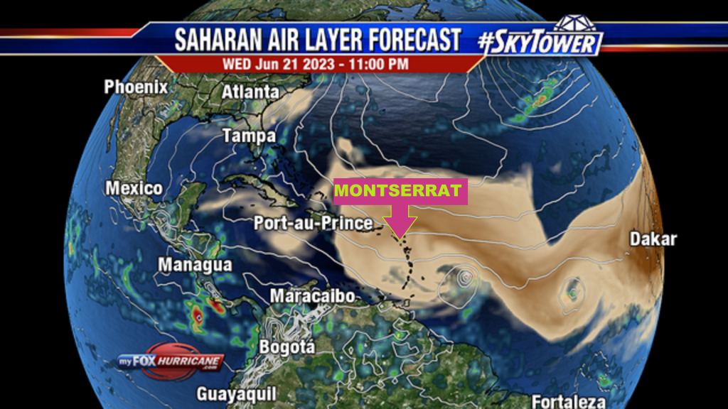
Air Quality Alert: Moderate Concentrations of Saharan Dust present in the atmosphere across Montserrat today, Wednesday, 21 June 2023, due to a fresh surge in the Saharan Dust – Persons with respiratory and heart ailments are advised to take the necessary precautions!
Active children and adults, and, people with respiratory diseases such as asthma, should limit prolonged outdoor exertion.
The Disaster Management Coordination Agency (DMCA) is advising residents who are unusually sensitive to dust particles to be vigilant, due to moderate concentrations of Saharan dust in the atmosphere! Residents with respiratory issues such as asthma should keep windows and doors closed as much as possible.
The DMCA is further advising residents to limit dust entering their system as best as possible by using masks and protective eyewear. Any masks that filter small particles should be worn such as a surgical mask, N95 and KN95 when going outside.
Air Quality Index Based on Particulate Matters 2.5 (PM2.5) and 10 (PM10) Concentration
Air quality category: Moderate
Location: Montserrat
Timing: Until Friday.
Synopsis: The air quality is down to moderate levels as a result of particulate matters 2.5 and 10, associated with a fresh surge in the Saharan Dust. The threat of health problems is elevated, for mainly unusually sensitive people, such as asthmatics, and could potentially cause them limited health impacts.
Air quality index: 51 to 70
Alert Level: II

Sensitive groups: People with respiratory or heart disease, the elderly and children are the groups most at risk.
Health implications: Air quality is acceptable; however, for some pollutants, there may be moderate health concerns for a very small number of people who are unusually sensitive to air pollution.
Continue to monitor DMCA Facebook, Instagram and Twitter social media sites and our website http://dmca.gov.ms for daily weather updates, public advisories and warnings and information on the wide range of natural and man-made hazards that have the potential to impact Montserrat.
Photos Courtesy: myFoxhurricane
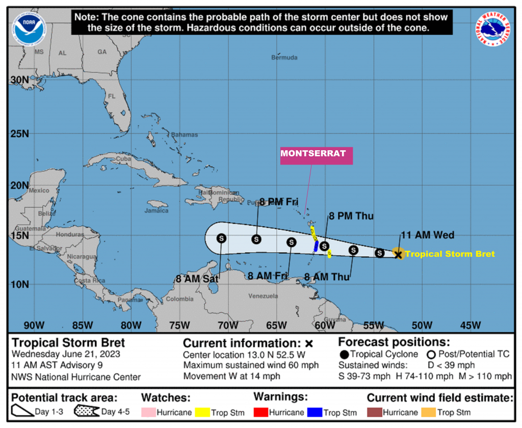
11 AM UPDATE: A TROPICAL CYCLONE ALERT REMAINS IN EFFECT FOR MONTSERRAT – ON ITS PRESENT TRACK, TROPICAL STORM BRET IS FORECAST TO PASS WELL SOUTH OF AND AT A SAFE DISTANCE FROM MONTSERRAT OVER ON THURSDAY AND FRIDAY. NO SPECIFIC ACTION IS REQUIRED OF RESIDENTS AT THIS TIME OTHER THAN TO KEEP MONITORING THE PROGRESS OF TROPICAL STORM BRET!
ACCORDING TO THE 11 AM TROPICAL ALERT STATEMENT ISSUED BY THE ANTIGUA AND BARBUDA METEOROLOGICAL SERVICES ON TUESDAY, 20 JUNE 2023, TROPICAL STORM BRET CONTINUES TO MOVE WESTWARDS.
AT 11 AM, THE CENTER OF TROPICAL STORM BRET WAS LOCATED NEAR LATITUDE 13.0 NORTH, LONGITUDE 52.5 WEST OR ABOUT 681 MILES SOUTHEAST OF THE LEEWARD ISLANDS INCLUDING MONTSERRAT.
BRET IS MOVING TOWARD THE WEST NEAR 14 MILES PER HOUR AND THIS GENERAL MOTION WITH AN INCREASE IN FORWARD SPEED IS EXPECTED TO CONTINUE DURING THE NEXT SEVERAL DAYS.

MAXIMUM SUSTAINED WINDS ARE NEAR 60 MPH WITH HIGHER GUSTS. SOME INCREASE IN STRENGTH IS EXPECTED BEFORE BRET REACHES THE LESSER ANTILLES ON THURSDAY BEFORE WEAKENING COMMENCES ON FRIDAY.
TROPICAL STORM FORCE WINDS EXTEND UP TO 60 MILES FROM THE CENTER.
THE ESTIMATED MINIMUM CENTRAL PRESSURE IS 1001 MB OR 29.56.
REPEATING THE 11 AM ECT POSITION, 13.0 N, 52.5 W. MOVEMENT TOWARD THE WEST NEAR 14 MPH. MAXIMUM SUSTAINED WINDS ARE NEAR 60 MPH. THE MINIMUM CENTRAL PRESSURE IS 1001 MB.
THE NEXT ADVISORY WILL BE AT 5 PM.
FORECASTER ORVIN PAIGE
