Major Hurricane Sam is moving out of the area… Last Formal Information Statement on Hurricane Sam.

The Antigua and Barbuda Meteorological Services said it continues to follow the progress of Major Hurricane Sam and the system is now moving out of the area.

In its tropical cyclone statement issued on Thursday September 30, 2021 at 11:45 am, it states that at the reasonable worst-case scenario, there is no potential for storm-force winds reaching Montserrat from Hurricane Sam. Hence, the cyclone poses no threat to Montserrat.

At 11 am, Major Hurricane Sam was centre over 370 miles nort-northheast of the Leeward Islands moving northwest at around 13 mph.

Maximum sustained winds are near 145 mph with higher gusts. Sam is a category 4 hurricane. Some fluctuations in intensity are expected during the next couple of days.

On its forecast track, the system will be out of the area by tomorrow. Notwithstanding, swells propagated by Sam have triggered high surf advisories and warnings.This is the last formal information statement on Hurricane Sam.

Residents should stay prepared for the rest of the hurricane season.

FORECASTER DALE DESTIN

TROPICS WATCH: Tropical Storm Victor in the Atlantic is no threat to landmass and the disturbance in the central Atlantic is running into hostile conditions, making chances for any significant development low.

Disturbance 1 located over the tropical Atlantic, about midway between the Cabo Verde Islands and the Lesser Antilles remains limited. This system is expected to move slowly west-northwest, and development is not anticipated, putting chances near 0% for it to develop into a tropical depression within five days.

Tropical Storm Victor located 550 miles south-southwest of the Cabo Verde Islands strengthened overnight with winds now up to 45 mph. Additional strengthening is forecast, and Victor could become a hurricane Friday before weakening over the weekend.

Hurricane Sam located 355 miles northeast of the Leeward Islands grew stronger overnight, with winds increasing to 145 mph. It’s expected to grow even stronger later today, with winds forecast to reach 150 mph within the next 12 hours.

The Disaster Management Coordination Agency, DMCA will continue to monitor the Atlantic and provide regular updates as new information is released from the NHC.

HURRICANE SAM UPDATE: Major Hurricane Sam is passing a comfortable distance northeast of Montserrat today, Wednesday September 29, 2021.

That’s according to the Antigua and Barbuda Meteorological Services.

In its tropical cyclone statement issued today at 11:50 am, it states that at the reasonable worst-case scenario, there is no potential for storm-force winds reaching Montserrat from Sam. Hence, the cyclone poses little to no threat to Montserrat.

The Meteorological Services said it will continue to follow the progress of the Hurricane Sam.

At 11 am, Major Hurricane Sam was located about 345 miles east-northeast of the Leeward Islands moving northwest at around 9 mph. Maximum sustained winds are near 130 mph with higher gusts. Sam is a category 4 hurricane. Some fluctuations in intensity are expected during the next couple of days.

On its forecast track, the system is passing over 300 miles northeast of the islands and should be out of the area by Friday. Notwithstanding, swells propagated by Sam have triggered high surf advisories, which may be upgraded to warnings in the next 24 hours.

Residents should continue to follow the progress of Hurricane Sam until it is out of the area. Also, all should stay prepared for the rest of the hurricane season.

The next update will be around 11 am tomorrow or sooner, if required.

Forecaster Dale Destin

UPDATE ON HURRICANE SAM: Major Hurricane Sam to pass a safe distance away from Montserrat on Wednesday, September 29, 2021

The Antigua and Barbuda Meteorological Services, in its latest tropical cyclone statement, issued on Tuesday September 28, 2021, states that Hurricane Sam is expected to pass a comfortable distance northeast of the Leeward Islands which include Montserrat tomorrow, Wednesday.

The Meteorological Services said given the reasonable worst-case scenario, there is no potential for storm-force winds reaching Montserrat from Sam. Hence, Hurricane Sam poses little to no threat Montserrat.

At 5 pm, Major Hurricane Sam was located about 530 miles east of the northern Leeward Islands which include Montserrat moving northwest at around 9 mph.

Maximum sustained winds are near 130 mph with higher gusts. Sam is a Category 4 hurricane on the Saffir-Simpson Hurricane Wind Scale. Some fluctuations in intensity are expected during the next couple of days, but Sam is forecast to remain a major hurricane through late this week.

On its forecast track, the system is expected to pass over 190 miles northeast of the islands tomorrow and be out of the area by Friday. Notwithstanding, swells propagated by sam have triggered high surf advisories, which may be upgraded to warnings in the next 24 hours.

Residents should continue to follow the progress of Hurricane Sam until it is out of the area. Also, all should stay prepared for the rest of the hurricane season.

The Next Update will be around 11 am tomorrow or sooner, if required.

Forecaster Dale Destin

TROPICS WATCH: DMCA MONITORS TWO TROPICAL DISTURBANCES IN THE EASTERN ATLANTIC WITH A HIGH CHANCE OF BECOMING TROPICAL DEPRESSIONS WITHIN A FEW DAYS!

Tuesday, September 28, 2021 – The Disaster Management Coordination Agency, DMCA is monitoring Tropical Disturbances 1 and 2 in the Eastern Atlantic forecast to become tropical depressions later this week as they move west-northwest. Disturbance 1 has an 80% chance of formation through the next five days as of the 8 a.m. update, while the disturbance behind it, had slightly higher chances at 80% for the next two days and 90% for the next five.

The National Hurricane Center issued the following advisories on the disturbances:

Tropical Disturbance 1 located several hundred miles southwest of the Cabo Verde Islands continues to produce an area of disorganized showers and thunderstorms. Environmental conditions are conducive for gradual development, and a tropical depression is likely to form during the next couple of days while the system moves westward to west-northwestward at 5 to 10 mph over the central tropical Atlantic. Formation chance through 48 hours is 70%. Formation chance through 5 days is 80%.

Tropical Disturbance 2 is broad area of low pressure located over the far eastern tropical Atlantic. Environmental conditions are conducive for development, and a tropical depression is likely to form in a day or two while the disturbance moves west-northwestward at 10 to 15 mph over the eastern tropical Atlantic. Formation chance through 48 hours is 80%. Formation chance through 5 days is 90%.

It’s too early at this time to determine if there will be any impact to Montserrat from the two(2) disturbances in the Atlantic. Hence, the Disaster Management Coordination Agency, DMCA is urging all residents on Montserrat to continue to monitor the tropics and always be prepared during what’s expected to be an active hurricane season.

The Disaster Management Coordination Agency, DMCA will continue to closely monitor Hurricane Sam and Tropical Disturbances 2 & 3, and provide regular updates as new information is released from the NHC.

The Antigua and Barbuda Meteorological Services has discontinued the Tropical Cyclone Alert for Montserrat as Hurricane Sam is forecast to pass a safe distance from the island!

It states that even at the reasonable worst-case scenario, there is no potential for storm-force winds reaching the island from Hurricane Sam. Hence, the cyclone now poses little to no threat Montserrat.

The Meteorological Services will continue to follow the progress of major Hurricane Sam. However, the hurricane is expected to pass a comfortable distance north of the northeast Caribbean.

At 5 pm, Major Hurricane Sam was located about 595 miles east-southeast of the Leeward Islands which in Montserrat moving northwest at around 9 mph.

Maximum sustained winds are near 120 mph with higher gusts. Sam is a category 3 hurricane. Some strengthening is forecast tonight. On Its Forecast track, the system is expected to pass over 170 miles north of the islands on Wednesday or Thursday and be out of the area by Friday. Notwithstanding, swells propagated by Sam are expected to trigger high surf advisories for much of the week.

Please Note, that no tropical cyclone alerts, watches or warnings are in effect and none will again be required for this system.

Residents should continue to follow the progress of Hurricane Sam until it is out of the area. Also, all should stay prepared for the rest of the hurricane season.

Forecaster Dale Destin

A High Surf Advisory goes into effect for the east-facing and north-facing coastlines on Montserrat from Tuesday September 28, 2021, until Thursday September 30, 2021!

Locations to be affected: Reefs and exposed mainly east-facing coastlines with relatively shallow, gently to moderately sloping near shore areas.

Timing: until Thursday for Montserrat

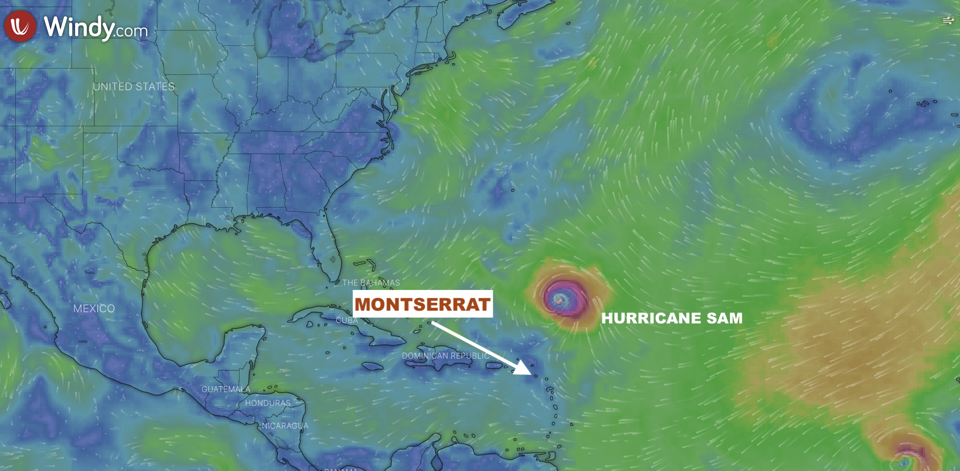
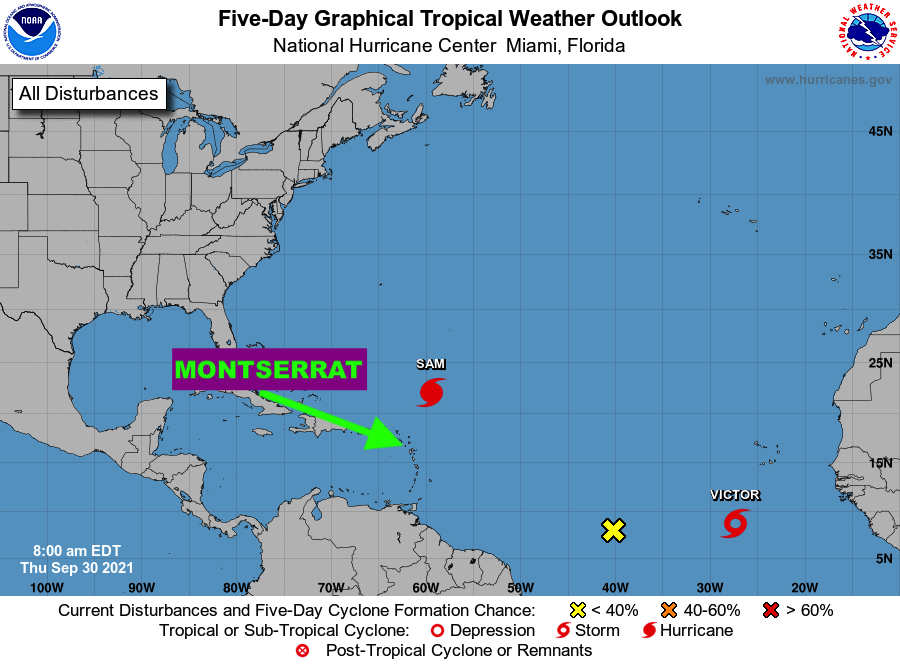
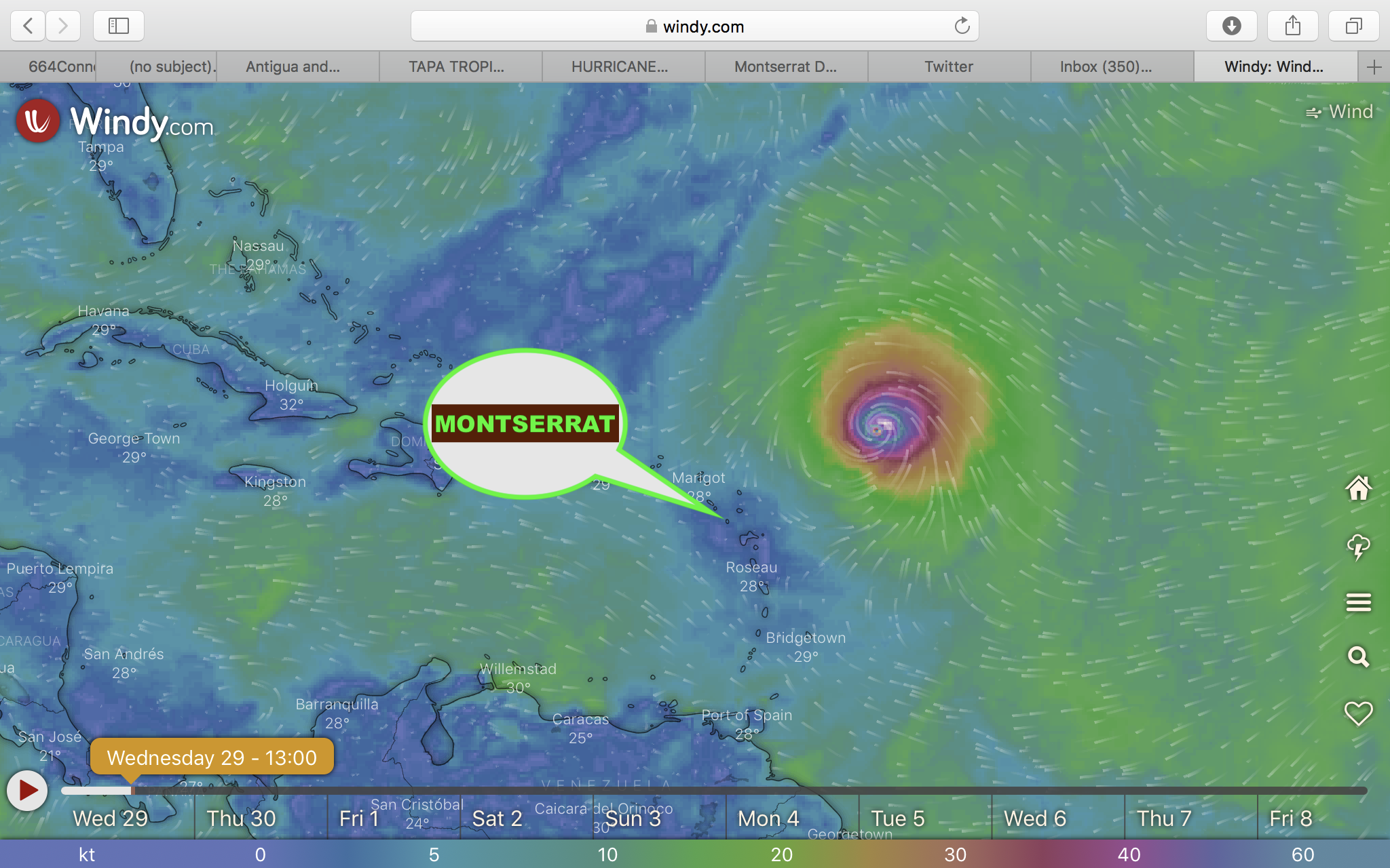
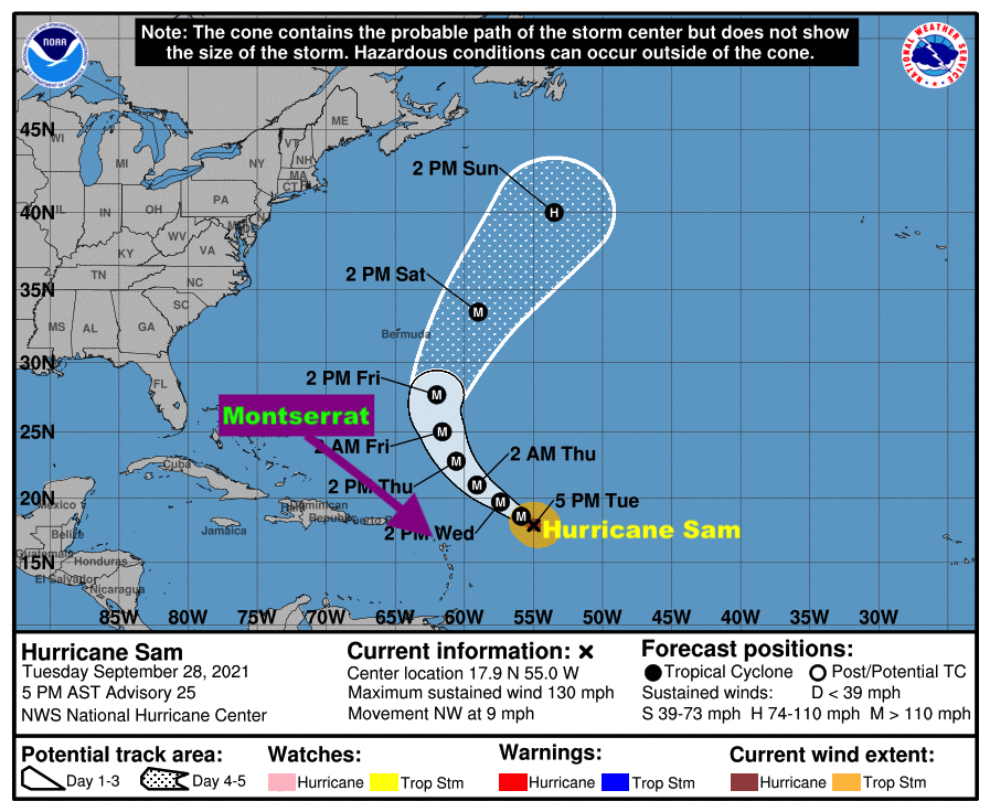
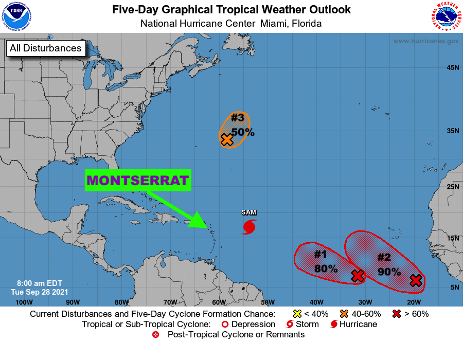
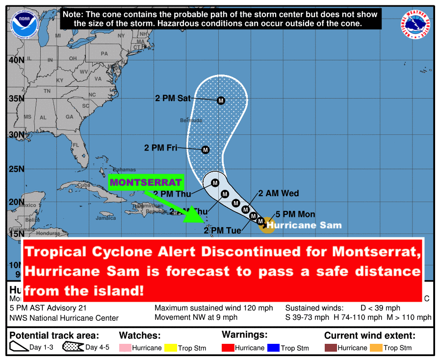
Synopsis: Major Hurricane Sam, although forecast to pass a safe distance away from the islands, it is expected to push moderate long period swells to the shores of the area, affecting mainly east-facing coastlines through Wednesday and north-facing coastlines on Thursday and Friday.

The threat level to the life, livelihood, property and infrastructure of those using the affected coastlines is forecast to rise to moderate, with the potential for significant impacts. These swells are expected to cause life-threatening surfs and rip currents near affected coastlines.

A high surf advisory means that dangerous surfs of 2 to 3 metres or 6 to 10 feet will affect some coastlines in the advisory area, producing hazardous conditions. A warning may be required Wednesday and Thursday for higher surfs.

Seas (significant wave heights): 1.5 to 2 metres (5 to 7 feet), occasionally or locally reaching near 3 metres (10 feet). Swell period: 9 to 14 seconds. Swells: East at 1.5 to 2 metres (5 to 7 feet) and occasionally higher.

Surfs (breaking swells): Over 2 metres (over 6 feet). These conditions are conducive for dangerous rip currents. Please note that surfs could be as much as twice the height of swells, depending on the bathymetry of the near shore areas.

Coastal flooding: High tides combine with onshore wind and swell actions could result in localized coastal flooding and beach erosion.

Potential Impacts: Loss of life–strong currents that can carry even the strongest swimmers out to sea; injuries to beachgoers; beach erosion; sea water splashing onto low lying coastal roads; beach closures; localized disruptions to marine recreation and businesses; financial losses; damage to coral reefs; saltwater intrusion and disruptions to potable water from desalination. High surfs can knock spectators off exposed rocks and jetties.

Precautionary: Beachgoers should be extremely cautious; bathe only where lifeguards are present or the sheltered, less affected beaches, mainly to the south and west.

Rip currents are powerful channels of water flowing quickly away from shore, which occur most often at low spots or breaks in the sandbar and near structures such as groins, jetties and piers. If caught in a rip current, relax and float. Don`t swim against the current. If able, swim in a direction following the shoreline. If unable to escape, face the shore and call or wave for help.

Forecaster: Dale Destin

12:05 PM HURRICANE SAM UPDATE: Hurricane Sam is still expected to pass at a Safe Distance Away from Montserrat with little or no wind impacts to the island!

However, The Antigua and Barbuda Meteorological Services, in its 12:05 PM Tropical Cyclone Statement, said a Tropical Cyclone Alert Remains in Effect for Montserrat and residents here on Montserrat are still urged to closely monitor the progress of Hurricane Sam until it clears the area.

The Meteorological Agency stated that based on current information and analysis, Hurricane Sam is still expected to pass at a safe distance away from Montserrat between Tuesday and Wednesday with little or no wind impacts to the islands; however swells associated with Sam could impact coastal areas as early as tonight to produce dangerous surfs and rip currents; as a result, a high surf advisory is likely to be issued shortly.

At 1100 am, the center of hurricane sam was located near latitude 15.6 north, longitude 52.0 west or approximately 745 miles east-southeast of the Leewards which include Montserrat.

Hurricane Sam is moving toward the northwest near 8 mph and this motion is expected to continue for the next few days, with an increase in forward speed beginning on Thursday. A turn to the north is expected on Friday. On the forecast track, Sam will pass well to the northeast of the northern Leeward islands which include Montserrat, on Wednesday and Thursday.

Maximum sustained winds are near 125 mph with higher gusts. Hurricane-force winds extend outward up to 30 miles from the center and tropical-storm-force winds extend outward up to 105 miles.

The minimum central pressure estimated from noaa hurricane hunter aircraft observations is 966 mb (28.53 inches).

Residents are again asked to closely monitor the progress of Hurricane Sam.The next advisory will be after 5 pm today.

FORECASTER LENARD JOSIAH

TROPICS WATCH: THE TWO (2) TROPICAL DISTURBANCES, FOLLOWING BEHIND HURRICANE SAM, COULD BECOME TROPICAL DEPRESSIONS THIS WEEK; DMCA MONITORS CLOSELY!

Monday, September 27, 2021: In addition to Hurricane Sam, The Disaster Management Coordination Agency is monitoring two (2) tropical disturbances in the Atlantic, both with high chances of becoming tropical cyclones in 5 days.

Disturbance 2 located several hundred miles southwest of the Cabo Verde Islands is expected to become a tropical depression in a few days expected,while Disturbance 3, moving offshore the west coast of Africa and into the far eastern tropical Atlantic is likely to develop into a tropical depressionin a few days. 

The National Hurricane Center issued the following advisories on the disturbances:

Tropical Disturbance 2 is located several hundred miles southwest of the Cabo Verde Islands.  Environmental conditions are forecast to be conducive for further development of this disturbance, and a tropical depression is likely to form in a few days while it moves westward to west-northwestward at 5 to 10 mph over the central tropical Atlantic. Formation chance through 48 hoursis 40%. Formation chance through 5 daysis 80%

Tropical Disturbance 3 is moving offshore the west coast of Africa and into the far eastern tropical Atlantic.  Upper-level winds are forecast to be conducive for gradual development, and a tropical depression is likely to form in a few days while the system moves westward to westnorthwestward at 10 to 15 mph over the far eastern tropical Atlantic. Formation chance through 48 hours is 40%. Formation chance through 5 days is 80%.

The Disaster Management Coordination Agency, DMCA will continue to closely monitor Hurricane Sam and Tropical Disturbances 2& 3 and  provide regular updates as new information is released from the NHC.

5 AM UPDATE: Hurricane Sam is expected to remain a Major Hurricane for the next several days, And is still Expected to Pass at A Safe Distance Away from Montserrat!

Also, A Tropical Cyclone Alert Remains in Effect for Montserrat; Residents urged to remain vigilant and continue to monitor of the progress of this Category 4 Hurricane.

According to the 5AM Tropical Cyclone Statement issued by the Antigua and Barbuda Meteorological Services on Monday September 27, 2021, it states that based on current information and analysis, Hurricane Sam is still expected to pass at a safe distance away from Montserrat between Tuesday and Wednesday with little or no wind and weather impact to the island. Swells associated with Sam could impact coastal areas as early as Wednesday to produce dangerous surfs and rip currents.

The threat level remains low. However any significant shift to the south-west could bring the cyclone closer to the islands which include Montserrat and elevate the threat level. Hence the need for residents to stay alert and vigilant in monitoring the progress of Hurricane Sam.

At 5 am, the center of hurricane sam was located near latitude 15.2 north, longitude 51.4 west or about 700 miles east-southeast of Antigua and Barbuda.

Sam is moving toward the northwest near 8 mph and this motion is expected to continue for the next few days, with an increase in forward speed beginning on Thursday.

Maximum sustained winds have decreased to near 130 mph with higher gusts. Sam is a Category 4 Hurricane on the Saffir-Simpson hurricane wind scale. Little chance in strength is expected during the next day or so. Thereafter, some slow weakening is forecast through midweek, although Sam should remain a major hurricane. Sam is a small hurricane.

Hurricane-force winds extend outward up to 30 miles from the center and tropical-storm-force winds extend outward up to 105 miles.

The estimated minimum central pressure is 952 mb (28.12 inches).

Residents are again asked to closely monitor the progress of Hurricane Sam.

The next advisory will be after 11am todayForecaster Bernell Simon