A Tropical Cyclone Alert remains in effect for Montserrat tonight!

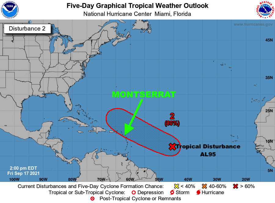
Residents should monitor Tropical Disturbance AL95 closely and have their Hurricane Plans prepared to safeguard Life, Property and Livelihood, in the event Watches Or Warnings are Issued within the next 48 Hours.

The Antigua and Barbuda Meteorological Services issued the following statement on Tropical Disturbance AL95 at 8 ‘clock tonight:

..TROPICAL DISTURBANCE AL95 COULD BECOME A TROPICAL CYCLONE AND AFFECT THE AREA…

A TROPICAL CYCLONE ALERT IS IN EFFECT FOR THE LEEWARD ISLANDS AND THE BRITISH VIRGIN ISLANDS. A TROPICAL CYCLONE ALERT MEANS THAT, IN THIS CASE, A TROPICAL DISTURBANCE WITH OVER A 50 PERCENT CHANCE OF BECOMING A TROPICAL CYCLONE IS IN OUR MONITORED AREA. WATCHES AND WARNINGS ARE NOT REQUIRED AT THIS TIME BUT MAY BE REQUIRED IN THE NEXT 48 HOURS.

GIVEN THE INHERENT FORECAST UNCERTAINTIES REGARDING AL95 WITH RESPECT TO TIME OF FORMATION, EVENTUAL TRACK, SIZE AND INTENSITY, IT IS NOT YET POSSIBLE TO SAY WITH HIGH CONFIDENCE WHAT WILL BECOME OF THIS SYSTEM. NOTWITHSTANDING, AT THE REASONABLE WORST-CASE, TROPICAL DISTURBANCE AL95 POSES A MODERATE THREAT WITH THE POTENTIAL TO CAUSE LIMITED IMPACTS FROM STORM-FORCE WINDS, HIGH SEAS AND MINOR FLOODING, RESULTING IN SOME DISRUPTIONS TO DAILY LIFE AND MINOR DAMAGE TO INFRASTRUCTURE. TO BE SAFE, BE PREPARED TO IMPLEMENT YOUR HURRICANE SEASON DISASTER PLANS.

AT 8 PM, THE CENTRE OF TROPICAL DISTURBANCE AL95 WAS LOCATED ABOUT 1100 MILES EAST-SOUTHEAST OF THE NORTHERN LEEWARD ISLANDS. THE DISTURBANCE IS  MOVING WEST-NORTHWEST AT 15 MPH.

MAXIMUM SUSTAINED WINDS ARE NEAR 25 MPH WITH HIGHER GUSTS. GRADUAL DEVELOPMENT IS FORECAST AND THE SYSTEM NOW HAS AN 80 PERCENT CHANCE OF BECOMING A TROPICAL CYCLONE IN 48 HOURS AND ALSO AN 80 PERCENT CHANCE IN FIVE DAYS. 
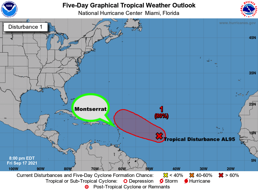
ON ITS FORECAST TRACK, THE SYSTEM WILL LIKELY BE AT IT’S CLOSEST POINT TO, AND IMPACT THE AREA LATE SUNDAY OR MONDAY. HOWEVER, THERE IS STILL A LOT OF TIME FOR IT TO SHIFT TO THE NORTH AND SPARE THE ISLANDS. 

RESIDENTS SHOULD MONITOR TROPICAL DISTURBANCE AL95 CLOSELY AND HAVE THEIR HURRICANE SEASON DISASTER PLANS PREPARED TO SAFEGUARD LIFE, PROPERTY AND LIVELIHOOD, IN THE EVENT WATCHES OR WARNINGS ARE ISSUED WITHIN THE NEXT 48 HOURS. 

THE NEXT UPDATE WILL BE AROUND 2 AM TOMORROW MORNING OR SOONER, IF REQUIRED.

FORECASTER  BERNELL SIMON
A Tropical Cyclone Alert is in effect for Montserrat

The full statement issued by The Antigua and Barbuda Meteorological Services on Friday September 17, 2021 is below…

…TROPICAL DISTURBANCE AL95 COULD BECOME A TROPICAL CYCLONE AND AFFECT THE AREA…

A TROPICAL CYCLONE ALERT IS IN EFFECT FOR THE LEEWARD ISLANDS AND THE BRITISH VIRGIN ISLANDS. A TROPICAL CYCLONE ALERT MEANS THAT, IN THIS CASE, A TROPICAL DISTURBANCE WITH OVER A 50 PERCENT CHANCE OF BECOMING A TROPICAL CYCLONE IS IN OUR MONITORED AREA. WATCHES AND WARNINGS ARE NOT REQUIRED AT THIS TIME BUT MAY BE REQUIRED IN THE NEXT 48 HOURS.

GIVEN THE INHERENT FORECAST UNCERTAINTIES REGARDING AL95, WITH RESPECT TO TIME OF FORMATION, EVENTUAL TRACK, SIZE AND INTENSITY, IT IS NOT YET POSSIBLE TO SAY WITH HIGH CONFIDENCE WHAT WILL BECOME OF THIS SYSTEM. NOTWITHSTANDING, AT THE REASONABLE WORST-CASE, TROPICAL DISTURBANCE AL95 POSES AN ELEVATED THREAT WITH THE POTENTIAL TO CAUSE LIMITED IMPACTS FROM STORM-FORCE WINDS, HIGH SEAS AND MINOR FLOODING, RESULTING IN LIFE-THREATENING CONDITIONS, SOME DISRUPTIONS TO DAILY LIFE AND MINOR DAMAGE TO INFRASTRUCTURE. TO BE SAFE, BE PREPARED TO IMPLEMENT YOUR HURRICANE SEASON DISASTER PLANS.

AT 2 PM, THE CENTRE OF TROPICAL DISTURBANCE AL95 WAS LOCATED ABOUT 1105 MILES EAST-SOUTHEAST OF THE LEEWARD ISLANDS MOVING WEST AT 15 MPH.

MAXIMUM SUSTAINED WINDS ARE NEAR 25 MPH WITH HIGHER GUSTS. GRADUAL DEVELOPMENT IS FORECAST AND THE SYSTEM HAS A 70 PERCENT CHANCE OF BECOMING A TROPICAL CYCLONE IN 48 HOURS AND AN 80 PERCENT CHANCE IN FIVE DAYS. ON ITS FORECAST TRACK, THE SYSTEM WILL LIKELY AFFECT THE AREA LATE SUNDAY OR MONDAY. HOWEVER, THERE IS STILL A LOT OF TIME FOR IT TO SHIFT TO THE NORTH AND SPARE THE ISLANDS.

RESIDENTS SHOULD MONITOR TROPICAL DISTURBANCE AL95 CLOSELY AND HAVE THEIR HURRICANE SEASON DISASTER PLANS PREPARED TO SAFEGUARD LIFE, PROPERTY AND LIVELIHOOD, IN THE EVENT WATCHES OR WARNINGS ARE ISSUED, SOMETIME IN THE NEXT 48 HOURS.

THE NEXT UPDATE WILL BE AROUND 9 PM THIS EVENING OR SOONER, IF REQUIRED.

FORECASTER DALE DESTIN

SEPTEMBER 17 ON MONTSERRAT IS THE ANNIVERSARY OF THREE (3) MAJOR MAJOR DISASTERS

On September 17 in different years, Montserrat experienced three (3) major disasters; the 1965 Pan-American Airways crash in Chance’s Mountain claiming the lives of all aboard, 21 passengers and nine crew members; Powerful Hurricane Hugo in 1989, and the first terrifying explosion of the Soufriere Hills volcano in 1996.

Hurricane Hugo made landfall on Montserrat as a Category 4 hurricane on September 17, 1989, with maximum sustained winds estimated near 145 mph and wind gusts estimated over 180 mph.

Hurricane Hugo began as a tropical disturbance off the West African coast on September 9, 1989. It belongs to the class of storms known as Cape- Verde hurricanes, which are usually the largest and most forceful tropical storms. Travelling westward, the system was upgraded to a Tropical Storm on September 11, 1989, and was named Hugo. Hugo gained intensity while crossing the Atlantic, and by September 13, 1989, it had gained hurricane strength with maximum sustained winds in excess of 74 mph.

Rapidly intensifying, Hugo reached hurricane strength and pounded the Leeward Islands as a powerful Category 5 hurricane with maximum sustained winds of 160 mph. Hugo was now a major hurricane.

Slowly moving west-northwest, Hugo slightly dropped to a Category 4 hurricane, and on September 16, at midnight, Hurricane Hugo began to affect Montserrat, slamming the island with fierce winds and intense rains.

At 7: 25 on the morning of September 17th, 1989, the eye of the Hurricane passed over Montserrat which means Hurricane Hugo hammered Montserrat for some 14 hours.

Hurricane Hugo devastated the entire island of Montserrat; ten (10) people were dead, 89 individuals were injured, 2500 people were homeless and 1200 people were in shelters while others stayed with neighbours, family and friends, 50% of the buildings were severely and extensively damaged and almost 100% of all buildings on Montserrat suffered at the minimum minor damage.

Damage from Hurricane Hugo was estimated at 1537 million EC dollars making it the most destructive and costly hurricane in the history of the island.Hugo’s devasted several other islands including Guadeloupe, the U.S. Virgin Islands, St. Croix, St. Thomas and Puerto .Rico.

DMCA MONITORS TROPICAL DISTURBANCE 1 IN THE ATLANTIC SHOWING SIGNS OF ORGANIZATION

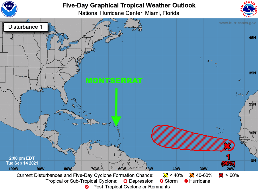
2PM UPDATE, TUESDAY SEPTEMBER 14, 2021 – The Disaster Management Coordination Agency, DMCA continues to monitor Tropical Disturbance 1 located few hundred miles south-southeast of the Cabo Verde Islands that continues to show signs of organization.

According to the 2 PM National Hurricane Center Advisory on Tropical Disturbance 1, it states that environmental conditions are expected to remain conducive for development of the disturbance, and a tropical depression is likely to form during the next couple of days while the system moves generally westward at about 15 mph across the eastern tropical Atlantic Ocean. The system has a high (70 percent) chance of formation during the next 48 hours and a high (90 percent) chance during the next five days.

It’s still way too early to predict what will become of this system and where it will go. However, residents are urged to continue to monitor the Atlantic for any changes with this tropical disturbance over the next several days.

The Disaster Management Coordination Agency, DMCA will continue to keep an eye on Tropical Disturbance 1 and will provide regular updates as new information is released.

HURRICANE LARRY TURNS NORTHWEST AS EXPECTED; HE’S NOT COMING OUR WAY; NO THREAT WHATSOEVER TO MONTSERRAT!

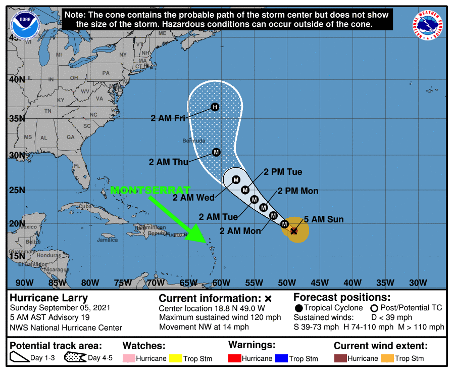
At 5 AM, the center of Hurricane Larry was located near latitude 18.8 North, longitude 49.0 West. Larry is moving toward the northwest near 14 mph (22 km/h). A northwestward motion with a slight decrease in forward speed is expected during the next few days.

Maximum sustained winds are near 120 mph with higher gusts.

Larry is a category 3 hurricane on the Saffir-Simpson Hurricane Wind Scale. Little change in strength is forecast during the next few days, although fluctuations in intensity will be possible. Larry is expected to remain a major hurricane through the middle of this week.

Hurricane-force winds extend outward up to 45 miles from the center and tropical-storm-force winds extend outward up to 160 miles.

The estimated minimum central pressure is 958 mb. A drifting buoy near the center of Larry recently measured a pressure of 962.9 mb.

HAZARDS AFFECTING LAND

———————-

SURF: Swells generated by Larry are expected to reach the Lesser Antilles today which includes Montserrat.

Continue to check the DMCA Facebook, Twitter and Instagram pages and our website http://dmca.gov.ms for daily updates.

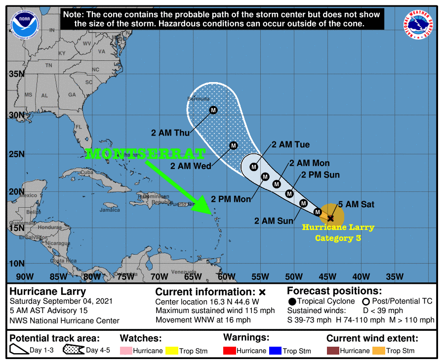
LARRY BECOMES A CATEGORY 3 HURRICANE AS THE STORM CONTINUES TO TURN AWAY FROM THE CARIBBEAN WHICH INCLUDES MONTSERRAT. IT IS FORECAST TO PASS OVER 300 MILES NORTHEAST OF MONTSERRAT ON MONDAY/TUESDAY AS A CATEGORY 4 HURRICANE.

RESIDENTS SHOULD CONTINUE TO MONITOR HURRICANE LARRY.

At 5 AM, the center of Hurricane Larry was located near latitude 16.3 North, longitude 44.6 West. Larry is moving toward the west-northwest near 16 mph. A slightly slower west-northwest to northwest motion is expected during the next few days.

Maximum sustained winds are near 115 mph with higher gusts. Larry is a category 3 Hurricane on the Saffir-Simpson Hurricane Wind Scale. Strengthening is forecast over the next day or two, and Larry is expected to remain at major hurricane strength through the early part of next week.

Hurricane-force winds extend outward up to 35 miles from the center and tropical-storm-force winds extend outward up to 150 miles.

The estimated minimum central pressure is 965 mb (28.50 inches).

HAZARDS AFFECTING LAND

———————-

SURF: Swells generated by Larry are expected to reach the Lesser Antilles which includes Montserrat on Sunday. These swells are likely to cause life-threatening surf and rip current conditions.

Residents should continue to monitor the Atlantic for any changes with Hurricane Larry.Continue to check the DMCA Facebook, Twitter and Instagram pages and our website http://dmca.gov.ms for daily updates.

The Disaster Management Coordination Agency, DMCA will continue to monitor the disturbance and provide regular updates accordingly.

Weather Authority and Photo Credits: NHC NOAA

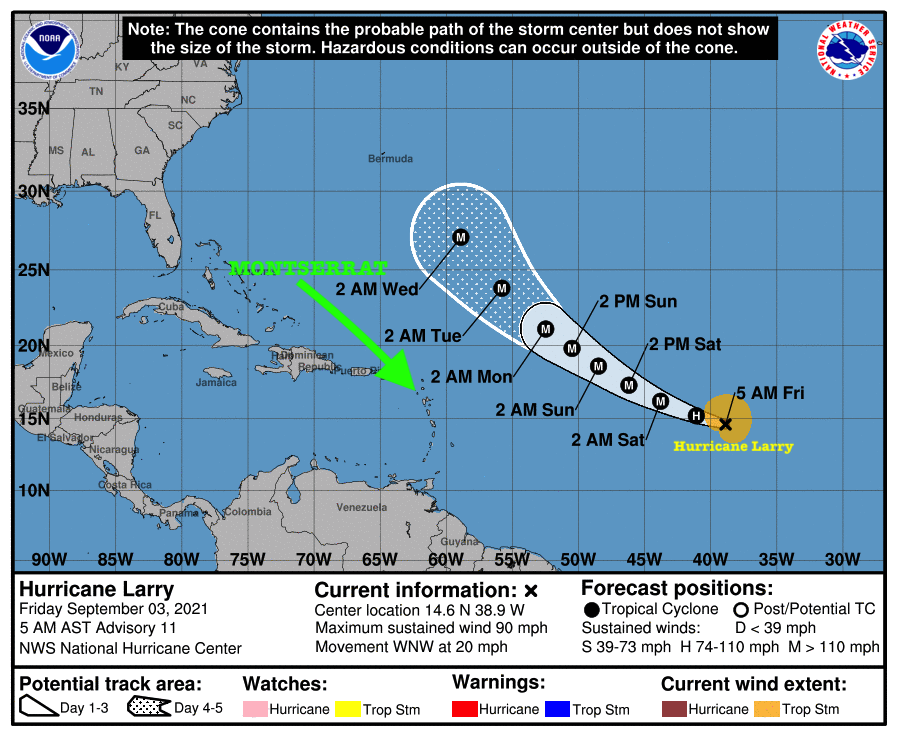
Hurricane Larry Continues to Strengthen Over the Eastern Atlantic Ocean moving quickly to the West-Northwest. At this time, there Is No Threat to Montserrat from Hurricane Larry. However, Residents Should Continue to Monitor the Progress of Larry.

Swells generated by Hurricane Larry are forecast to reach the Lesser Antilles which Includes Montserrat on Sunday. These Swells are Likely to Cause Life-Threatening Surf and Rip Current Conditions.

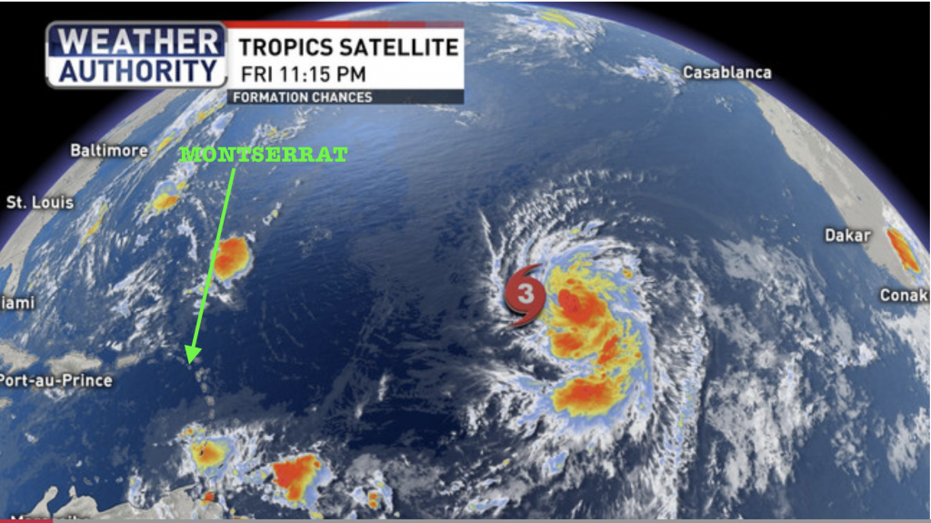
The National Hurricane Center said Hurricane Larry continues to gradually become better organized with winds of 90 mph winds. It states that Larry is expected to become a major hurricane by Friday night.

At 5 AM, the center of Hurricane Larry was located near latitude 14.6 North, longitude 38.9 West. Larry is moving toward the west-northwest near 20 mph (31 km/h) and this motion is expected during the next few days. A turn to the northwest is forecast by early next week.Maximum sustained winds have increased to near 90 mph (150 km/h) with higher gusts. Additional strengthening is forecast during the next few days, and Larry could become a major hurricane by tonight.

Hurricane-force winds extend outward up to 25 miles (35 km) from the center and tropical-storm-force winds extend outward up to 150 miles.

The estimated minimum central pressure is 982 mb (29.00 inches).

HAZARDS AFFECTING LAND

———————-

SURF: Swells generated by Larry are expected to reach the Lesser Antilles on Sunday. These swells are likely to cause life-threatening surf and rip current conditions.

Continue to check the DMCA Facebook, Twitter and Instagram pages and our website http://dmca.gov.ms for daily updates.

The Disaster Management Coordination Agency, DMCA will continue to monitor Tropical Storm Larry and provide regular updates accordingly.

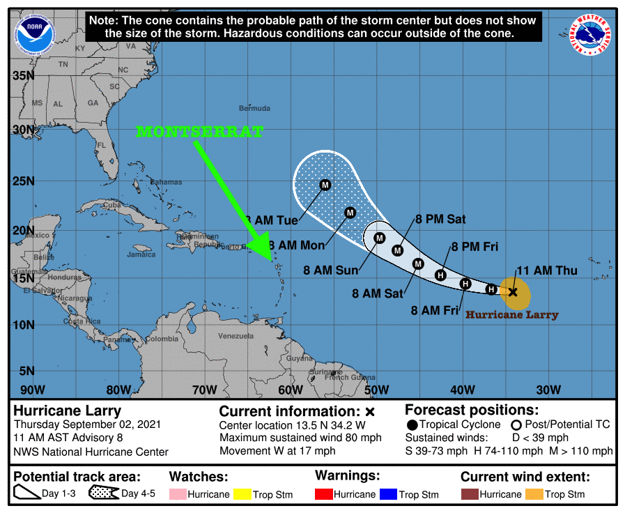
HURRICANE LARRY CONTINUES TO STRENGTHEN STILL MOVING WEST, BUT FORECAST MODELS HAVE THE SYSTEM STARTING TO TURN AWAY FROM THE ISLANDS WHICH INCLUDES MONTSERRAT BY TOMORROW, FRIDAY.

RESIDENTS SHOULD CONTINUE TO MONITOR THE PROGRESS OF HURRICANE LARRY.

Yellow Hill, Montserrat, Thursday September 2, 2021 – The National Hurricane Center said Larry is getting larger and a bit stronger, now up to 80 mph winds, a Category 1 hurricane. It states that Larry is expected to become a major hurricane by Friday night.

At 11 AM, the center of Hurricane Larry was located near latitude 13.5 North, longitude 34.2 West. Larry is moving toward the west near 17 mph (28 km/h).

A gradual turn towards the west-northwest with a decrease in forward speed are expected over the next few days. Maximum sustained winds have increased to near 80 mph (130 km/h) with higher gusts. Steady to rapid strengthening is forecast during the next couple of days, and Larry is expected to become a a major hurricane by Friday night.

Hurricane-force winds extend outward up to 15 miles (30 km) from the center. Recent satellite wind data indicates that the tropical-storm-force wind radii are expanding and now extend outward up to 160 miles (260 km).

The estimated minimum central pressure is 985 mb (29.09 inches).

Continue to check the DMCA Facebook, Twitter and Instagram pages and our website http://dmca.gov.ms for daily updates.

The Disaster Management Coordination Agency, DMCA will continue to monitor Tropical Storm Larry and provide regular updates accordingly.

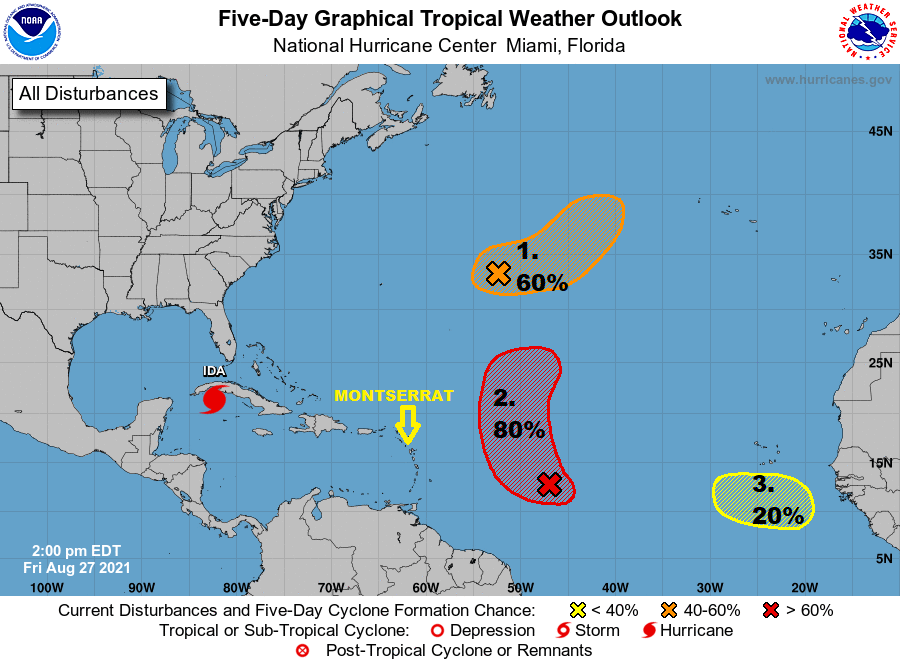
2 PM TROPICAL WEATHER OUTLOOK – 3 TROPICAL DISTURBANCES IN THE ATLANTIC AND 1 HURRICANE IN THE WESTERN CARIBBEAN.

A New Tropical Disturbance (yellow) is expected to emerge off the west African coast by the middle of next week. The system has a 20% chance of tropical development in 5 days.

The other two disturbances in the Atlantic have a 60% (orange) and an 80% (red) chance of tropical cyclone formation over the next 5 days, respectively.

Tropical Storm Ida has rapidly intensified and is now a hurricane impacting Cuba.

None of the Tropical Disturbances appears to be a threat to Montserrat at this time.

Residents, visitors, and in particular, the vulnerable are urged to be informed, be prepared and remain vigilant as we’re at the peak of the 2021 Atlantic Hurricane Season.

Continue to check the DMCA Facebook, Twitter and Instagram pages and our website http://dmca.gov.ms for daily updates.

The Disaster Management Coordination Agency, DMCA will continue to monitor the Tropical Atlantic in case of any changes with these tropical disturbances.