AND, A TROPICAL CYCLONE ALERT REMAINS IN EFFECT FOR MONTSERRAT; RESIDENTS SHOULD CONTINUE TO MONITOR THE PROGRESS OF HURRICANE SAM.
A Tropical Cyclone Alert means that, in this case, a hurricane is in our monitored area. Watches and Warnings are not required at this time, but may be necessary in the next 72 hours.
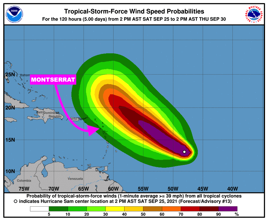
In a tropical cyclone statement issued on Saturday September 25, 2021 at 5: 43PM, the Antigua and Barbuda Meteorological Services said based on current information and analysis, Hurricane Sam, which is a small, but dangerous” hurricane is expected to pass at a safe distance away from MONTSERRAT between Tuesday and Wednesday with little or no impact to the island with respect to winds, cloudiness and showers.
Therefore, there is a very low threat to the island. However given the dynamic nature of tropical cyclones any shift to the south could bring the cyclone closer to the islands. Hence the need for continuous monitoring.
At 5 pm, the center of hurricane sam was located near latitude 13.3 north, longitude 48.5 west or about 924 miles east-southeast of the leeward islands. Sam is moving toward the west-northwest near 10 mph. A slower motion to the west-northwest is expected over the weekend, followed by a turn to the northwest on Monday.

Maximum sustained winds have increased to near 140 mph with higher gusts. Sam is a category 4 hurricane on the saffir-simpson hurricane wind scale. Additional strengthening is expected through tonight.
The estimated minimum central pressure is 960 mb (28.35 inches).
Residents should continue to monitor the progress of Hurricane Sam.
The next advisory on this system will be issued after 11 pm tonight.
FORECASTER ORVIN PAIGE
