…TROPICAL STORM JERRY CONTINUES MOVING QUICKLY WEST-NORTHWESTWARD…
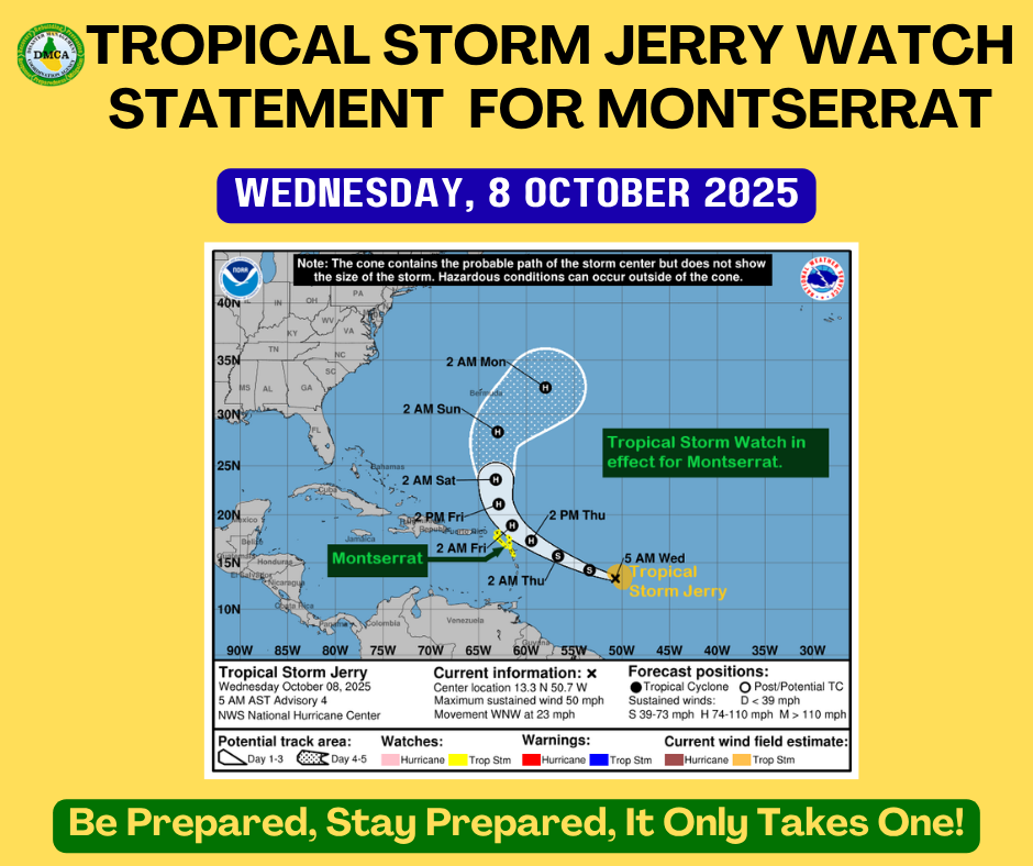
A Tropical Storm Watch remains in effect for Montserrat.
A Tropical Storm Watch means that tropical-storm or developing tropical-storm conditions pose a possible threat to the specified area within 48 hours. Residents should begin to implement their hurricane preparedness plans.
At 5:00 AM, the centre of Tropical Storm Jerry was located near latitude 13.3° North, longitude 50.7° West, or about 804 miles east-southeast of Montserrat.
Jerry is moving toward the west-northwest at 23 mph. This general motion is expected to continue, with a gradual decrease in forward speed during the next couple of days, followed by a turn toward the north-northwest and north beginning on Friday.
Maximum sustained winds are near 50 mph, with higher gusts. Strengthening is expected over the next few days, and Jerry is forecast to become a hurricane on Thursday.
Tropical-storm-force winds extend outward up to 125 miles from the centre.
The estimated minimum central pressure is 1003 mb.
Based on the latest observations and analysis, the core of Jerry is expected to pass near or to the north of the northern Leeward Islands late Thursday into Friday.
Jerry will continue to be monitored closely, and information on potential impacts will be communicated as the system moves closer to the islands over the coming days.
?? All residents are urged to monitor the movement of Jerry closely and take action to protect life and property. A Tropical Storm Warning is likely within the next 24 hours.
? Repeating the 5:00 AM ECT position:
Location: 13.3° N, 50.7° W
Movement: West-northwest near 23 mph
Maximum sustained winds: 50 mph
Minimum central pressure: 1003 mb
The next advisory will be issued at 11:00 AM.
Forecaster: Patrice Edwards