Synopsis: A tropical wave is approaching the Eastern Caribbean. However most of the cloudiness and showers will pass south of the Leeward Islands and British Virgin Islands.
Weather tonight: Partly cloudy with a 30 percent or low chance of showers.
Weather tomorrow: Partly cloudy with a 30 percent or low chance of showers.Winds: East at 15 to 28 km/h or 9 to 17 mph.
Seas: 1.2 to 1.8 metres or 4 to 6 feet.Sunrise tomorrow: 5:55 pm.
Weather Report: Antigua and Barbuda Meteorological Services Orvin Paige-Forecaster
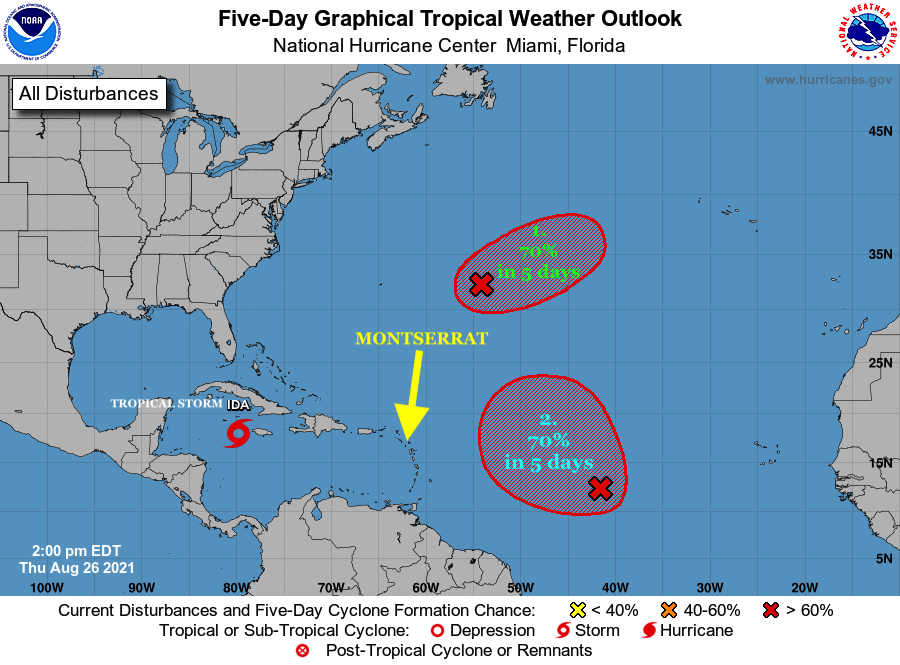
Tropical Storm Ida has formed in the Caribbean Sea. The system was located about 130 miles SE of Grand Cayman moving NW at 14 mph with maximum sustained winds of 40 mph. Steady strengthening is forecast during the next few days. A Tropical Storm Warning is in effect for the Cayman Islands, Cuban provinces of Matanzas, Mayabeque, Havana, Artemisa, Pinar del Rio, and the Isle of Youth.
The other two Tropical Disturbances in the Tropical Atlantic being monitored both have a 70% chance of Tropical cyclone formation over the next 5 days, respectively. At this time, none of the Tropical Disturbances appear to be a threat to Montserrat.
Residents, visitors, and in particularly, the vulnerable are urged to be informed, be prepared and remain vigilant as we’re in the peak of the 2021 Atlantic Hurricane Season.
Continue to check the DMCA Facebook, Twitter and Instragam pages and our website http://dmca.gov.ms for daily updates.
The Disaster Management Coordination Agency, DMCA will continue to monitor the Tropical Atlantic in case of any changes with these tropical disturbances.
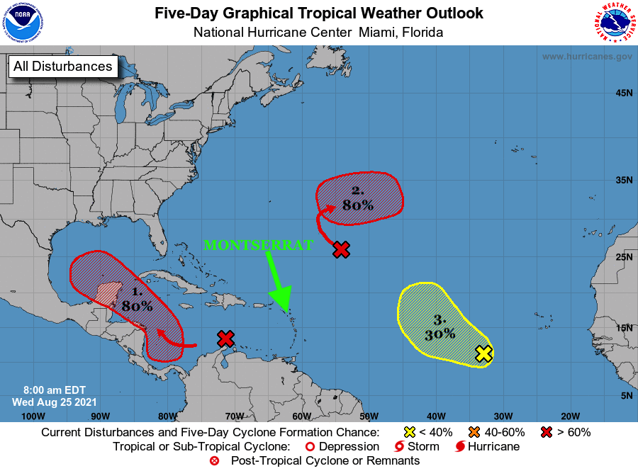
Three (3)Tropical Disturbances are still in the Caribbean and the Atlantic with 80% (red), 80% (red) and 30% (yellow) chance of Tropical cyclone formation over the next 5 days respectively.
At this time, none of the Tropical Disturbances appear to be a threat to Montserrat.
Residents, visitors, and in particularly, the vulnerable are urged to be informed, prepared and vigilant as we’re in the peak of the 2021 Atlantic Hurricane Season.
Continue to check the DMCA Facebook, Twitter and Instragam pages and our website http://dmca.gov.ms for daily updates.
The Disaster Management Coordination Agency, DMCA will continue to monitor the Tropical Atlantic in case of any changes with these tropical disturbances.
Synopsis: Stable and dry conditions will continue to inhibit shower activity for the next 24hrs.
Weather today: Mostly sunny and hazy.
Weather tonight: Mostly fair and hazy.Winds: East at 17 to 30 km/h or 10 to 18 mph.
Seas: Not exceeding 1.5 metres or 5 feet.Sunset today: 6:28 pm.
Sunrise tomorrow: 5:55 am.Temperatures: daytime highs reaching 31°C or 90°F.
Air Quality Index is 55-85, which is moderate, due to the presence of Saharan dust in the atmosphere. People with Respiratory Illnesses and Diseases should minimize their time outside and wear a mask if they must be outdoors. The arrival of the Saharan dust layer is not unusual and is normally expected between late April and October.
Remember, the weather can change at a moment’s notice, Stay Ahead! Events such as flash floods can occur with little or no warning due to prolonged rain, rain showers in the higher elevations and the soil already saturated.
Weather Report: Antigua and Barbuda Meteorological ServicesPatrice Edwards-Forecaster
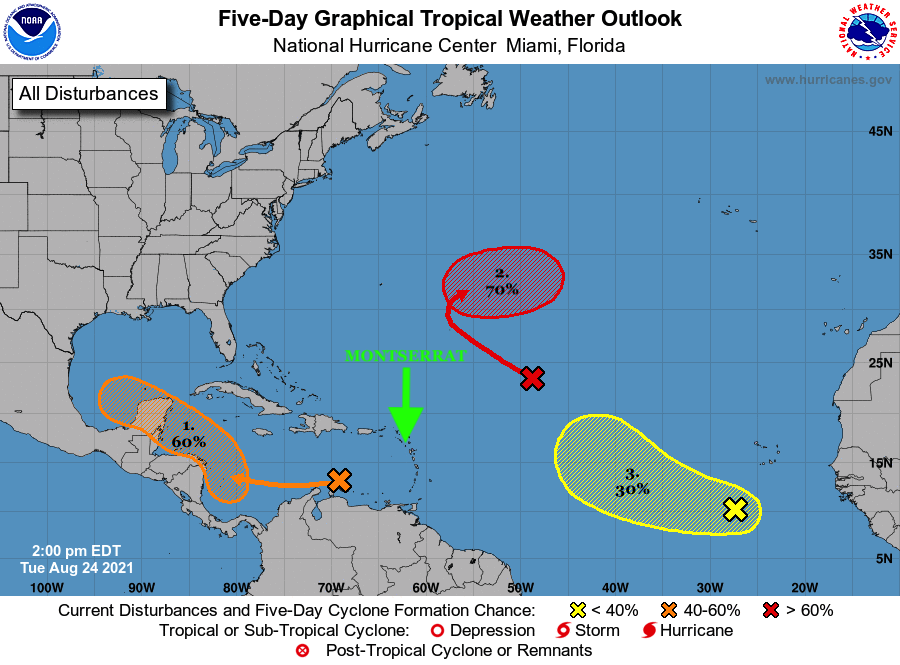
Three (3)Tropical Disturbances in the Caribbean and the Atlantic with 60% (orange), 70% (red) and 30% (yellow) chance of Tropical Development over the next 5 days respectively.
At this time, none of the Tropical Disturbances appear to be a threat to Montserrat.
Residents, visitors, and in particularly, the vulnerable are asked remain vigilant and prepared and continue to monitor the Atlantic for any changes with these systems as we’re in the climatological peak of the 2021 Atlantic Hurricane Season.
Continue to check the DMCA Facebook, Twitter and Instragam pages and our website http://dmca.gov.ms daily updates.
The Antigua and Barbuda Meteorological Services has issued a flash flood watch for flash-flood prone areas on Montserrat. These are the low lying areas across the island and the Belham Valley River.
The flash flood threat level is elevated and there is the potential for limited to significant impacts in the watch areas. To be safe, implement your flood plan.
Timing: Tonight 8 pm until Sunday 8 am.
Synopsis: Tropical Storm Grace is expected to pass through the area. This will result in heavy showers. Rainfall rates of 60 mm (2.4 in) per hour or more are possible with isolated higher total will produce minor flooding and may produce moderate or worse flash flooding.
Potential Impacts: Localised disruption to transportation; localised population displacement; erosion; environmental degradation; localised damage to dams, embankment, irrigation and drainage facilities; high sediments transport into reservoir; localised disruption to communication; localised contamination of potable water; localised loss of livestock; financial losses; injuries; temporary stoppage of health services and damage to infrastructure.
Precautionary/preparedness actions: A flash flood watch means that flooding is possible but not imminent in the watch area.
Residents in these areas should make preparations to protect life, property and livelihood against flooding and be prepared to move to higher ground, if heavy rains develop.
THAT’S ACCORDING TO A TROPICAL CYCLONE WARNING STATEMENT ISSUED BY THE ANTIGUA AND BARBUDA METEOROLOGICAL SERVICES FOR MONTSERRAT AT 9:46 PM FRIDAY, AUGUST 13, 2021…
A TROPICAL STORM WARNING IS NOW IN EFFECT FOR MONTSERRAT.
A TROPICAL STORM WARNING MEANS THAT TROPICAL STORM CONDITIONS ARE EXPECTED WITHIN THE SPECIFIED AREA WITHIN 36 HOURS.THE DEPRESSION IS FORECAST TO BECOME A TROPICAL STORM TONIGHT OR ON SATURDAY AS IT NEARS THE ISLANDS.
AT THIS TIME, IT IS MOST LIKELY THAT IT WILL BE A MODERATE TROPICAL STORM WHEN IT REACHES HOWEVER, THERE STILL REMAINS SOME UNCERTAINTY AS TO THE EXACT STRENGTH THEREFORE RESIDENTS ARE URGED TO IMPLEMENT THEIR HURRICANE PREPAREDNESS PLANS FOR A POTENTIALLY STRONG TROPICAL STORM. AT THE REASONABLE WORST-CASE SENARIO THE SYSTEM COULD POSE A MODERATE THREAT, WITH THE POTENTIAL TO CAUSE SIGNIFICANT IMPACTS FROM STORM FORCE WINDS, HIGH SEAS AND MODERATE FLOODING RESULTING IN SOME DISRUPTIONS TO DAILY LIFE AND DAMAGE TO WEAK INFRASTRUCTURE.
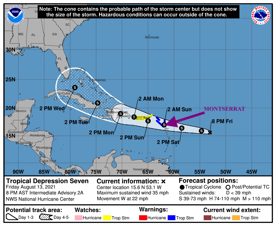
AT 8 PM, THE CENTER OF TROPICAL DEPRESSION SEVEN WAS LOCATED NEAR LATITUDE 15.6 NORTH, LONGITUDE 53.1 WEST OR ABOUT 610 MILES EAST OF MONTSERRAT.
THE DEPRESSION IS MOVING QUICKLY TOWARD THE WEST NEAR 22 MPH (35 KM/H). A MOTION TOWARD THE WEST OR WEST-NORTHWEST WITH A GRADUAL DECREASE IN FORWARD SPEED IS EXPECTED DURING THE NEXT FEW DAYS. ON THE FORECAST TRACK, THE CENTER OF THE DEPRESSION IS FORECAST TO MOVE OVER THE LEEWARD ISLANDS SATURDAY NIGHT.
MAXIMUM SUSTAINED WINDS ARE NEAR 35 MPH (55 KM/H) WITH HIGHER GUSTS. SOME STRENGTHENING IS FORECAST DURING THE NEXT COUPLE OF DAYS.THE ESTIMATED MINIMUM CENTRAL PRESSURE IS 1010 MB (29.83 INCHES).BASED ON THE FORECAST TRACK THE SYSTEM WILL LIKELY AFFECT MONTSERRAT LATE SATURDAY INTO SUNDAY. SKIES WILL BECOME OVERCAST WITH SHOWERS AND THUNDERSTORMS LATE SATURDAY AND INTO MOST OF SUNDAY.
RAINFALL TOTALS IN EXCESS OF 2 INCHES ARE ALSO LIKELY AND COULD LEAD TO FLOODING IN LOW LYING AND FLOOD PRONE AREAS. RESIDENTS IN THESE AREAS SHOULD KEEP THIS IN MIND.
SEAS WILL DETERIORATE WITH THE PASSAGE OF THE DEPRESSION AND COULD PEAK NEAR 2.8 METERS OR 9 FEET.
THEREFORE MARINERS SHOULD STAY IN PORT BEGINNING LATE SATURDAY INTO SUNDAY.
ALL RESIDENTS ARE URGED TO MONITOR THE MOVEMENT OF TROPICAL DEPRESSION SEVEN CLOSELY AND ACT TO PROTECT LIFE AND PROPERTY.FORECASTER LETITIA HUMPHREYS
Winds up to 40 miles per hour with higher gusts are possible with the passage of the Depression.
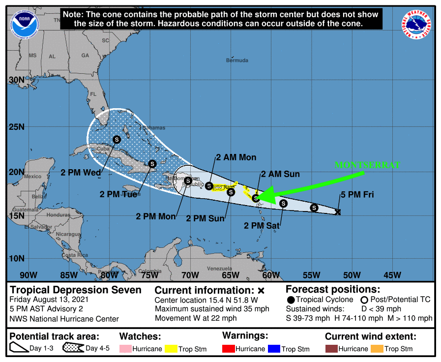
Here’s the rest of the Tropical Depression Seven Watch Statement issued by the Antigua and Barbuda Meteorological Services on Friday, August 13, 2021 at 4:48 pm….
TROPICAL DEPRESSION FORMS EAST OF THE LESSER ANTILLES…A TROPICAL STORM WATCH IS IN EFFECT FOR MONTSERRAT.
A TROPICAL STORM WATCH MEANS THAT TROPICAL STORM CONDITIONS ARE POSSIBLE WITHIN THE WATCH AREA IN 48 HOURS. A WARNING MAY BE REQUIRED IN THE NEXT 12 HOURS.
AT 5PM, THE CENTER OF TROPICAL DEPRESSION SEVEN WAS LOCATED NEAR LATITUDE 15.4 NORTH, LONGITUDE 51.8 WEST OR ABOUT 697 MILES EAST OF MONTSERRAT. THE DEPRESSION IS MOVING TOWARD THE WEST NEAR 22 MPH (35 KM/H). A MOTION TOWARD THE WEST OR WEST-NORTHWEST WITH A GRADUAL DECREASE IN FORWARD SPEED IS EXPECTED DURING THE NEXT FEW DAYS. ON THE FORECAST TRACK, THE CENTER OF THE DEPRESSION IS FORECAST TO MOVE OVER THE LEEWARD ISLANDS SATURDAY NIGHT, OVER THE VIRGIN ISLANDS AND PUERTO RICO ON SUNDAY, AND THEN OVER THE DOMINICAN REPUBLIC ON MONDAY.
MAXIMUM SUSTAINED WINDS ARE NEAR 35 MPH WITH HIGHER GUSTS. SOME STRENGTHENING IS FORECAST DURING THE NEXT COUPLE OF DAYS, AND THE DEPRESSION IS EXPECTED TO BECOME A TROPICAL STORM TONIGHT OR ON SATURDAY.
THE ESTIMATED MINIMUM CENTRAL PRESSURE IS 1010 MB (29.83 INCHES).BASED UPON THE LATEST POSITION AND ANALYSES, TROPICAL DEPRESSION SEVEN IS EXPECTED TO PASS NEAR MONTSERRAT EARLY SUNDAY AS A MINIMAL TROPICAL STORM. SKIES WILL BECOME INCREASINGLY CLOUDY WITH SHOWERS AND THUNDERSTORMS LATE SATURDAY AND INTO MOST OF SUNDAY.
RAINFALL TOTAL IN EXCESS OF TWO INCHES ARE ALSO LIKELY AND COULD LEAD TO FLOODING IN LOW LYING AND FLOOD PRONE AREAS.WINDS TO TROPICAL STORM STRENGTH, THAT IS WINDS OF UP TO 40 MILES PER HOUR WITH HIGHER GUSTS ARE POSSIBLE WITH THE PASSAGE OF THE DEPRESSION.
SEAS WILL DETERIORATE WITH THE PASSAGE OF THE DEPRESSION AND COULD PEAK NEAR 2.8 METRES OR 9 FEET. MARINERS SHOULD STAY IN PORT BEGINNING LATE SATURDAY AND ON SUNDAY.
AT THIS TIME, NO PARTICULAR ACTION IS REQUIRED OF RESIDENTS OF MONTSERRAT OTHER THAN TO KEEP MONITORING THE PROGRESS OF THE DEPRESSION.
THE NEXT UPDATE ON THIS SYSTEM WILL BE AROUND 8 PM THIS EVENING.
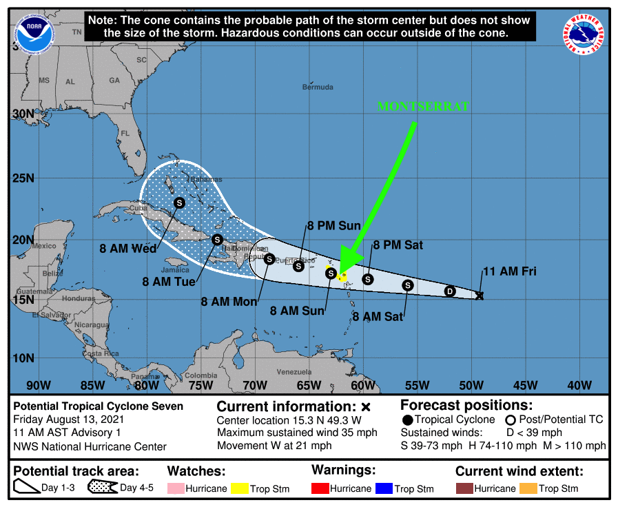
THAT’S ACCORDING TO A TROPICAL STORM WATCH STATEMENT ISSUED BY THE ANTIGUA AND BARBUDA METEOROLOGICAL SERVICES TODAY….
POTENTIAL TROPICAL CYCLONE SEVEN LIKELY TO BECOME A TROPICAL STORM AND AFFECT THE AREA…
A TROPICAL STORM WATCH IS IN EFFECT FOR MONTSERRAT. A TROPICAL STORM WATCH MEANS THAT TROPICAL STORM CONDITIONS ARE POSSIBLE WITHIN THE WATCH AREA IN 48 HOURS. A WARNING MAY BE REQUIRED IN THE NEXT 24 HOURS.
TROPICAL DISTURBANCE AL IS NOW POTENTIAL TROPICAL CYCLONE SEVEN. THERE ARE STILL INHERENT UNCERTAINTIES; HOWEVER, THE SYSTEM IS FORECAST TO BECOME A TROPICAL STORM AS IT NEARS THE ISLANDS.
AT THE REASONABLE WORST-CASE, THE SYSTEM POSES A MODERATE THREAT, WITH THE POTENTIAL TO CAUSE SIGNIFICANT IMPACTS FROM STORM-FORCE-WINDS, HIGH SEAS AND MODERATE FLOODING, RESULTING IN LIFE-THREATENING CONDITIONS, DISRUPTIONS TO DAILY LIFE AND DAMAGE TO INFRASTRUCTURE. TO BE SAFE, START TO IMPLEMENT YOUR HURRICANE SEASON DISASTER PLANS FOR A STRONG TROPICAL STORM.
AT 11 AM, THE CENTRE OF POTENTIAL TROPICAL CYCLONE SEVEN WAS LOCATED NEAR LATITUDE 15.3 NORTH, LONGITUDE 49.3 WEST OR ABOUT 846 MILES EAST-SOUTHEAST OF THE MONTSERRAT MOVING WEST AT 21 MPHMAXIMUM SUSTAINED WINDS ARE NEAR 35 MPH WITH HIGHER GUSTS. GRADUAL DEVELOPMENT IS FORECAST AND THE SYSTEM IS EXPECTED TO BECOME A TROPICAL DEPRESSION TONIGHT AND TROPICAL STORM BY SATURDAY.
FORMATION CHANCE TO A TROPICAL CYCLONE IS 80 PERCENT OR HIGH, THROUGH 48 HOURS.ON ITS TRACK, THE SYSTEM WILL LIKELY AFFECT MONTSERRAT LATE SATURDAY INTO SUNDAY.
AT THIS TIME, IT IS MOST LIKELY THAT WILL BE A MODERATE TROPICAL STORM WHEN IT REACHES THE ISLANDS; HOWEVER, THERE IS THE POTENTIAL FOR IT TO IMPACT THE AREA AS A STRONG TROPICAL STORM.
NOTWITHSTANDING, THERE IS STILL ENOUGH TIME FOR IT TO SHIFT TO THE NORTH AND SPARE THE ISLANDS THE WORST OF ITS WEATHER.
RESIDENTS SHOULD START TO IMPLEMENT THEIR HURRICANE SEASON PLANS FOR POTENTIALLY A STRONG TROPICAL STORM TO SAFEGUARD LIFE, PROPERTY AND LIVELIHOOD, IN THE EVENT A WARNING IS ISSUED, BY EARLY TOMORROW.
THE NEXT UPDATE WILL BE AROUND 5 PM THIS AFTERNOON OR SOONER, IF REQUIRED.
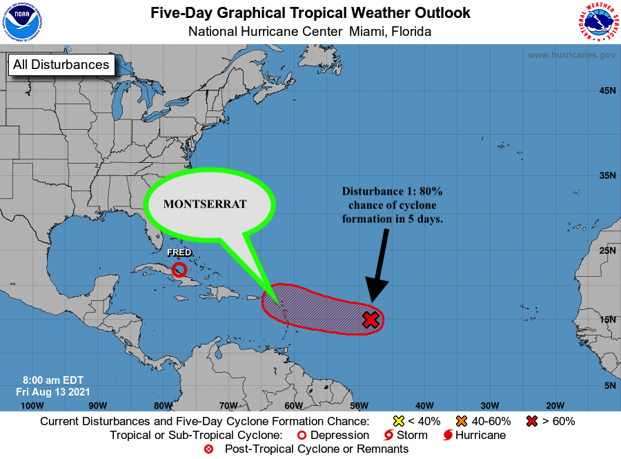
THE ANTIGUA AND BARBUDA METEOROLOGICAL SERVICES ISSUED THE FOLLOWING TROPICAL CYCLONE ALERT STATEMENT AT 8:30 AM ON FRIDAY, AUGUST 13, 2021…
TROPICAL DISTURBANCE AL95 COULD BECOME A TROPICAL CYCLONE AND AFFECT THE AREA…A TROPICAL CYCLONE ALERT IS IN EFFECT FOR THE LEEWARD ISLANDS WHICH INCLUDES MONTSERRAT. A TROPICAL CYCLONE ALERT MEANS THAT, IN THIS CASE, A TROPICAL DISTURBANCE WITH OVER A 50 PERCENT CHANCE OF BECOMING A TROPICAL CYCLONE IS IN OUR MONITORED AREA. WATCHES AND WARNINGS ARE NOT REQUIRED AT THIS TIME BUT MAY BE REQUIRED IN THE NEXT 48 HOURS.
GIVEN THE FORECAST UNCERTAINTIES REGARDING AL95 FORECAST TRACK, SIZE AND INTENSITY, IT IS NOT YET POSSIBLE TO SAY WITH HIGH CONFIDENCE WHAT WILL BECOME OF THIS SYSTEM AT THIS TIME.
NOTWITHSTANDING, AT THE REASONABLE WORST-CASE, TROPICAL DISTURBANCE AL95 POSES A MINOR THREAT WITH THE POTENTIAL TO CAUSE LIMITED IMPACTS FROM STORM-FORCE WINDS, HIGH SEAS AND MINOR FLOODING, RESULTING IN SOME DISRUPTIONS TO DAILY LIFE AND MINOR DAMAGE TO INFRASTRUCTURE. TO BE SAFE, BE PREPARED TO IMPLEMENT YOUR HURRICANE SEASON DISASTER PLANS.
AT 8 AM, TROPICAL DISTURBANCE AL95 WAS LOCATED ABOUT 850 MILES EAST OF THE LEEWARD ISLANDS. AL95 CONTINUES TO MOVE TOWARDS THE WEST OR WEST-NORTHWEST AT 20 MPH.
MAXIMUM SUSTAINED WINDS ARE NEAR 30 MPH WITH HIGHER GUSTS. SOME GRADUAL DEVELOPMENT IS FORECAST AND THE SYSTEM NOW HAS A 80 PERCENT CHANCE OF BECOMING A TROPICAL CYCLONE BY THE WEEKEND.
ON ITS FORECAST TRACK, THE SYSTEM WILL LIKELY AFFECT THE LEEWARD ISLANDS LATE SATURDAY INTO SUNDAY. HOWEVER, THERE IS STILL SOME TIME FOR IT TO SHIFT AND SPARE THE ISLANDS.
RESIDENTS SHOULD MONITOR TROPICAL DISTURBANCE AL95 CLOSELY AND HAVE THEIR HURRICANE SEASON PLANS PREPARED TO SAFEGUARD LIFE, PROPERTY AND LIVELIHOOD, IN THE EVENT THAT WATCHES OR WARNINGS ARE ISSUED WITHIN THE NEXT 48 HOURS.
THE NEXT ADVISORY WILL BE AT 2 PM OR SOONER IF REQUIRED.