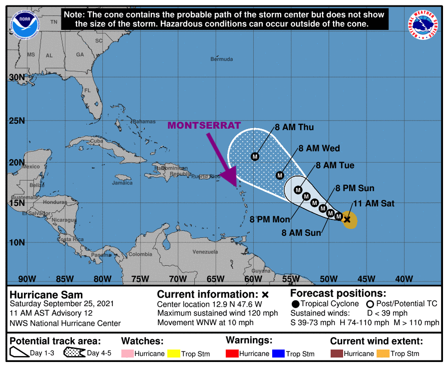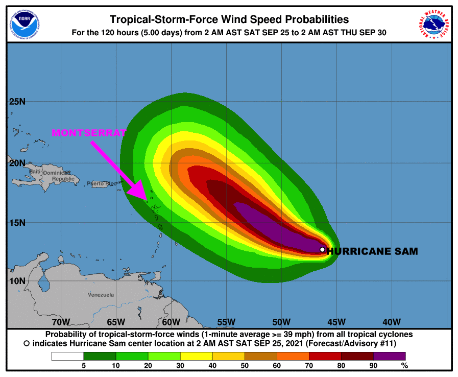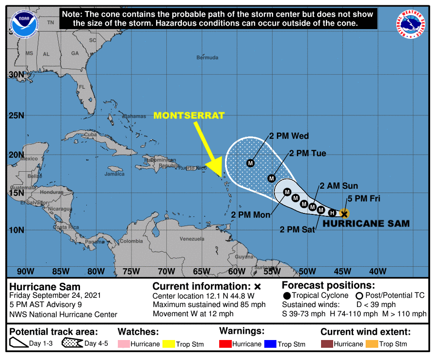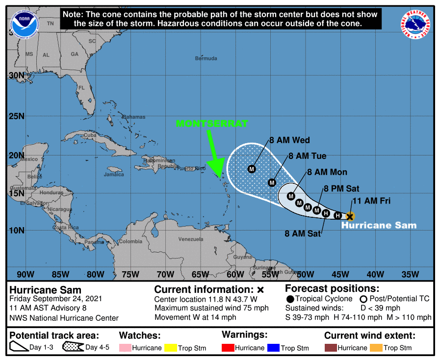
A TROPICAL CYCLONE ALERT REMAINS IN EFFECT FOR MONTSERRAT; HURRICANE SAM LIKELY TO PASS NORTH OF THE ISLANDS, BUT WE ARE NOT OUT OF THE WOODS!

The Antigua and Barbuda Meteorological Services in its 11 am Hurricane Sam Alert statement issued on Friday September 24, 2021, said on its forecast track, Hurricane Sam will likely pass a relatively safe distance northeast or north of the area Tuesday or Wednesday.

However, the Meteorological Services said they cannot rule out that there is a very low chance that Hurricane Sam could pass closer to the islands with minimal impacts.

Residents should monitor the movements of Hurricane Sam and be prepared to activate their Hurricane Preparedness Plans if a watch or warning becomes necessary.

Full statement below:…

HURRICANE SAM LIKELY TO PASS NORTH OF THE ISLANDS BUT WE ARE NOT OUT OF THE WOODS…

A TROPICAL CYCLONE ALERT IS IN EFFECT FOR THE LEEWARD ISLANDS AND THE BRITISH VIRGIN ISLANDS. A TROPICAL CYCLONE ALERT MEANS THAT, IN THIS CASE, A HURRICANE IS IN OUR MONITORED AREA. WATCHES AND WARNINGS ARE NOT REQUIRED AT THIS TIME BUT MAY BE NECESSARY IN THE NEXT 72 HOURS.

HURRICANE SAM IS LIKELY TO PASS A SAFE DISTANCE AWAY FROM THE ISLANDS, HOWEVER GIVEN THE DYNAMIC NATURE OF TROPICAL CYCLONES, THERE IS A VERY LOW CHANCE THAT HURRICANE SAM COULD PASS CLOSE ENOUGH TO THE ISLANDS TO CAUSE MINIMAL IMPACTS WITH RESPECT TO WINDS, CLOUDINESS AND SHOWERS AND ELEVATED SEAS. FOR THESE REASONS NO SPECIFIC ACTION IS REQUIRED OTHER THAN TO MONITOR THE PROGRESS OF HURRICANE SAM.

AT 11 AM, THE CENTRE OF HURRICANE SAM WAS LOCATED NEAR LATITUDE 11.8 N, LONGITUDE 43.7 WEST OR APPROXIMATELY 1350 MILES EAST-SOUTHEAST OF THE LEEWARD ISLANDS AND MOVING WEST AT 14 MPH.

MAXIMUM SUSTAINED WINDS ARE NEAR 75 MPH WITH HIGHER GUSTS. RAPID INTENSIFICATION IS FORECAST TO CONTINUE AND SAM IS FORECAST TO BECOME A MAJOR HURRICANE TONIGHT OR EARLY SATURDAY. ON ITS FORECAST TRACK, THE SYSTEM WILL LIKELY PASS A RELATIVELY SAFE DISTANCE NORTHEAST OR NORTH OF THE AREA TUESDAY OR WEDNESDAY.

HOWEVER, WE CANNOT RULE OUT THAT THERE IS A VERY LOW CHANCE THAT SAM COULD PASS CLOSER TO THE ISLANDS WITH MINIMAL IMPACTS.

RESIDENTS SHOULD MONITOR THE MOVEMENTS OF HURRICANE SAM AND BE PREPARED TO ACTIVATE THEIR HURRICANE PREPAREDNESS PLANS IF A WATCH OR WARNING BECOMES NECESSARY.

THE NEXT UPDATE WILL BE ISSUED JUST AFTER 5 PM TODAY.

FORECASTER ORVIN PAIGE

A Tropical Cyclone Alert is in effect for Montserrat for Hurricane Sam.

In a statement issued on Friday September 24, 2021, The Antigua and Barbuda Meteorological Services, states that given the uncertainty in the forecast track, intensity and size of Hurricane Sam, it is impossible to predict what the exact impacts, if any, are expected to occur this far in advance.

However, residents should go over their hurricane disaster plans and continue to monitor this system closely.

FULL STATEMENT BELOW:

SAM IS NOW A HURRICANE, AND RAPID INTENSIFICATION IS FORECAST TO CONTINUE…

A TROPICAL CYCLONE ALERT IS IN EFFECT FOR THE LEEWARD ISLANDS AND THE BRITISH VIRGIN ISLANDS. A TROPICAL CYCLONE ALERT MEANS THAT, IN THIS CASE A HURRICANE IS IN OUR MONITORED AREA BUT A WATCH OR WARNING IS NOT REQUIRED AT THIS TIME.GIVEN THE UNCERTAINTY IN THE FORECAST TRACK , INTENSITY AND SIZE OF THE TROPICAL CYCLONE , IT IS IMPOSSIBLE TO PREDICT WHAT THE EXACT IMPACTS, IF ANY, ARE EXPECTED TO OCCUR THIS FAR IN ADVANCE. NOTWITHSTANDING, SAM IS EXPECTED TO BECOME A MAJOR HURRICANE TONIGHT OR EARLY SATURDAY AS IT MOVES CLOSER TO THE AREA.

SAM IS FORECAST TO BE OF LITTLE TO THREAT TO THE AREA, AS THE FORECAST PATH KEEP IT AT A SAFE DISTANCE; HOWEVER, RESIDENTS SHOULD GO OVER THEIR HURRICANE DISASTER PLANS AND CONTINUE TO MONITOR THIS SYSTEM CLOSELY….

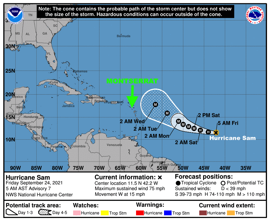
AT 5 AM, THE CENTRE OF HURRICANE SAM WAS LOCATED NEAR LATITUDE 11.5 NORTH,LONGITUDE 42.2 WEST OR ABOUT 1470 MILES EAST-SOUTHEAST OF THE LEEWARD ISLANDS AND BRITISH VIRGIN ISLANDS.

HURRICANE SAM IS MOVING TOWARD THE WEST AT 15 MILES PER HOUR. THIS GENERAL MOTION IS EXPECTED TO CONTINUE THROUGH TO TONIGHT. A DECREASE IN FORWARD SPEED AND A SHIFT TO THE WEST-NORTHWEST IS EXPECTED OVER THE WEEKEND.

MAXIMUM SUSTAINED WINDS HAVE INCREASED TO 75 MPH WITH HIGHER GUSTS. RAPID INTENSIFICATION IS FORECAST TO CONTINUE AND SAM IS LIKELY TO BECOME A MAJOR HURRICANE TONIGHT OR EARLY SATURDAY.

HURRICANE FORCE WINDS EXTEND UP TO 15 MILES FROM THE CENTRE AND TROPICAL STORM FORCE WINDS EXTEND OUTWARD UP TO 60 MILES.

THE ESTIMATED MINIMUM CENTRAL PRESSURE IS 993 MB OR 29.33 INCHES.ALL RESIDENTS ARE URGED TO MONITOR THE MOVEMENT OF SAM CLOSELY AND BE PREPARED TO ACT.

THE NEXT ADVISORY WILL BE AT 11 AM.FORECASTER PATRICE EDWARDS

DMCA CONGRATULATES CDEMA FOR ITS CONTRIBUTION TO PROMOTING THE PRACTICE OF COMPREHENSIVE DISASTER MANAGEMENT (CDM) IN THE CARIBBEAN REGION WHICH INCLUDES MONTSERRAT FOR THE PAST 30 YEARS!

In this special feature, the Director of the Disaster Management Coordination Agency, DMCA, on Montserrat extends congratulations to the Caribbean Disaster Emergency Management Agency, CDEMA, on the agency’s 30th Anniversary.

CDEMA celebrated its 30th anniversary on September 9, 2021, of providing Disaster Response Services and support to the region in the areas of Comprehensive Disaster Risk Management including Disaster Response.

CDEMA, formerly the Caribbean Disaster Emergency Response Agency (CDERA) was created in 1991 as a specialized regional institution with a mandate to advance and deepen functional cooperation across CARICOM Member Countries, which includes Montserrat, in Disaster Risk Management.


Happy Anniversary and our best wishes for many years to come!

AT 5PM, TROPICAL STORM SAM CONTINUES TO STRENGTHEN IN THE ATLANTIC OCEAN AND IS FORECAST TO BECOME A HURRICANE ON FRIDAY MORNING, MOVING WEST AT 16 MPH.

Thursday September 23, 2021 – The Disaster Management Coordination Agency, DMCA is closely monitoring Tropical Storm Sam located about 1635 miles East-Southeast of the Northern Leeward Islands which includes Montserrat. The system is expected to come close to a major category 3 hurricane by the end of the weekend with top winds of 111 to 129 mph, according to the National Hurricane Center.

The majority of long-range forecast models have Tropical Storm Sam turning north or north east of the Caribbean which includes Montserrat, hence residents should continue to watch the storm closely.

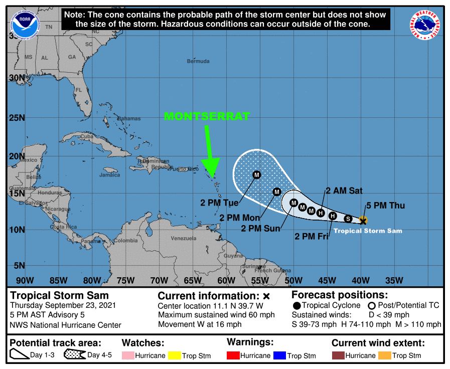
At 5 PM, the center of Tropical Storm Sam was located near latitude 11.1 North, longitude 39.7 West. Sam is moving toward the west near 16 mph (26 km/h) and a general west to west-northwest motion is expected to continue over the next several days, with a gradual slowdown in forward motion.Maximum sustained winds have increased to near 60 mph with higher gusts. Rapid intensification is forecast during the next several days. Sam is forecast to become a hurricane tomorrow morning and could become a major hurricane by Saturday.Tropical-storm-force winds extend outward up to 60 miles from the center.

The estimated minimum central pressure is 1000 mb (29.53 inches).

HAZARDS AFFECTING LAND: None.

The Disaster Management Coordination Agency, DMCA will continue to keep an eye on Tropical Storm Sam, and will provide regular updates as new information is released.

DMCA CLOSELY MONITORS TROPICAL STORM SAM LOCATED ABOUT 1,745 MILES EAST-SOUTHEAST OF THE NORTHERN LEEWARD ISLANDS MOVING WEST AT 16 MPH

The Disaster Management Coordination Agency, DMCA is closely monitoring Tropical Storm Sam forecast to become a hurricane by tomorrow and a major hurricane (Category 3 or more) early next week.

The majority of long-range forecast models have the storm turning north or north east of the Caribbean which includes Montserrat, hence residents should continue to watch the storm closely.

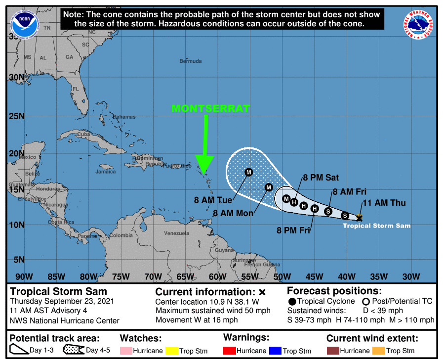
At 11 AM, the center of Tropical Storm Sam was located near latitude 10.9 North, longitude 38.1 West. Sam is moving toward the west near 16 mph and this general motion is expected to continue over the next several days, but with a gradual slowdown in forward motion.

Recent sallite wind data indicates maximum sustained winds have increased to near 50 mph with higher gusts. Additional strengthening is forecast over the next several days, and Sam is now forecast to become a hurricane tomorrow and be near major hurricane intensity by the end of the weekend. Tropical-storm-force winds extend outward up to 45 miles from the center.

The estimated minimum central pressure is 1003 mb (29.62 inches).

HAZARDS AFFECTING LAND – None.

The Disaster Management Coordination Agency, DMCA will continue to keep an eye on Tropical Storm Sam, and will provide regular updates as new information is released.

TROPICAL DEPRESSION 18 FORMS IN THE EASTERN TROPICAL ATLANTIC OCEAN, AND IS FORECAST TO BECOME A TROPICAL STORM IN 24 HOURS AND A MAJOR HURRICANE BY NEXT WEEK!

The Disaster Management Coordination Agency is closely monitoring Tropical Depression 18 located about 2030 miles ESE of the Northern Leeward Islands which include Montserrat.

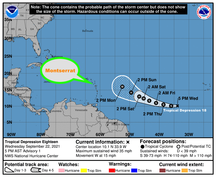
At 5 PM, the center of Tropical Depression Eighteen was located near latitude 10.1 North, longitude 33.9 West. The depression is moving toward the west near 15 mph and this motion is expected to continue for the next day or so followed by a gradual turn to the west-northwest by Friday.Maximum sustained winds are near 35 mph with higher gusts.

Strengthening is forecast over the next several days.

The depression is forecast to become a tropical storm by tomorrow, and could be near hurricane intensity by the weekend.The estimated minimum central pressure is 1008 mb (29.77 inches).

Residents are urged to continue to monitor the Atlantic for any changes with Tropical Depression 18 over the next several days.

The Disaster Management Coordination Agency, DMCA will continue to keep an eye on Tropical Depression 18, and will provide regular updates as new information is released.

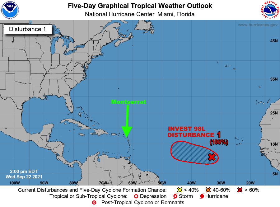
A NEW TROPICAL DEPRESSION COULD FORM THIS AFTERNOON OR IN THE EVENING IN THE EASTERN ATLANTIC

In its 2 pm advisory, the National Hurricane Center said a tropical depression could form Wednesday afternoon or evening.

The NHC said Disturbance 1 known as INVEST 98L is becoming better defined and is expected to move west at 10 to 15 mph into the central Atlantic over the next few days.

Residents are urged to continue to monitor the Atlantic for any changes with Tropical Disturbance 1 over the next several days.

The Disaster Management Coordination Agency, DMCA will continue to keep an eye on Tropical Disturbances 1, and will provide regular updates as new information is released.

DISTURBANCE DESIGNATED INVEST 98L IN THE EASTERN ATLANTIC OCEAN IS FORECAST TO BECOME A TROPICAL DEPRESSION WITHIN 48 HOURS; DMCA MONITORS!

Wednesday September 22, 2021 – The Disaster Management Coordination Agency, DMCA is this morning monitoring Tropical Disturbance 1 known as INVEST 98L (red) located several hundred miles southwest of the Cabo Verde Islands.

According to the National Hurricane Center, showers and thunderstorms continue to become better organized in association with INVEST 98L.

It states that environmental conditions are expected to remain conducive for additional development, and a tropical depression is expected to form within a day or two while the system moves westward at 10 to 15 mph across the eastern and central tropical Atlantic Ocean. INVEST 98L now has a 90% chance of becoming a tropical cyclone in 2 days.

Residents are urged to continue to monitor the Atlantic for any changes with this Tropical Disturbance 1 over the next several days.

The Disaster Management Coordination Agency, DMCA will continue to keep an eye on Tropical Disturbances 1, and will provide regular updates as new information is released.

DMCA MONITORS DISTURBANCE DESIGNATED INVEST 98L IN THE EASTERN ATLANTIC OCEAN WITH A 90% PROBABILITY OF BECOMING A TROPICAL CYCLONE BY THIS WEEK!

Tuesday September 21, 2021 – The Disaster Management Coordination Agency, DMCA is monitoring Tropical Disturbance 1 (red) located a few hundred miles southwest of the Cabo Verde Islands. The tropical disturbance is designated INVEST 98L by the National Hurricane Center (NHC).

The NHC said environmental conditions are expected to become more conducive for development of INVEST 98L, and a tropical depression is likely to form by Thursday or Friday, while the system moves westward at 10 to 15 mph across the eastern, and central tropical Atlantic Ocean. The disturbance (INVEST 98L) has a 70% chance of becoming a tropical cyclone in 5 days.

Residents are urged to continue to monitor the Atlantic for any changes with Tropical Disturbance 1 (INVEST 98L) over the next several days.

The Disaster Management Coordination Agency, DMCA will continue to monitor Tropical Disturbances 1 (INVEST 98L) progression, and keep you updated as new information is released from the NHC.

…TROPICAL STORM PETER IS PASSING A SAFE DISTANCE AWAY FROM THE ISLANDS…

TROPICAL CYCLONE INFORMATION STATEMENT

ANTIGUA AND BARBUDA METEOROLOGICAL SERVICES
11:45 AM ECT MON SEP 20 2021

  
…TROPICAL STORM PETER IS PASSING SAFE DISTANCE AWAY FROM THE ISLANDS…

THE ANTIGUA AND BARBUDA METEOROLOGICAL SERVICES CONTINUES TO FOLLOW THE PROGRESS OF  TROPICAL STORM PETER. 

PETER POSES LITTLE TO NO THREAT TO ANTIGUA AND BARBUDA, THE REST OF THE LEEWARD ISLANDS AND THE BRITISH VIRGIN ISLANDS. ALSO, THE SYSTEM POSES NO THREAT TO THE REST OF THE CARIBBEAN.

AT 11 AM, TROPICAL STORM PETER WAS CENTRED ABOUT 175 MILES NORTH-NORTHEAST OF THE LEEWARD ISLANDS MOVING WEST-NORTHWEST AT AROUND 15 MPH. 

MAXIMUM SUSTAINED WINDS ARE NEAR 50 MPH WITH HIGHER GUSTS. SLOW WEAKENING IS FORECAST OVER THE NEXT FEW DAYS. 

ON ITS FORECAST TRACK, THE SYSTEM IS EXPECTED TO BE OUT OF THE AREA BY WEDNESDAY.

PLEASE NOTE THAT NO TROPICAL CYCLONE ALERTS, WATCHES OR WARNINGS ARE IN EFFECT AND NONE WILL AGAIN BE REQUIRED FOR THIS SYSTEM.

RESIDENTS SHOULD CONTINUE TO FOLLOW THE PROGRESS OF TROPICAL STORM PETER UNTIL IT IS OUT OF THE AREA. 

THE NEXT UPDATE WILL BE AROUND 11 AM TOMORROW OR SOONER, IF REQUIRED.

FORECASTER DALE DESTIN