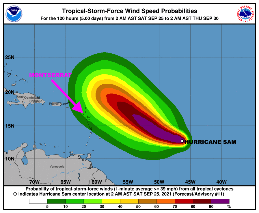
12:05 PM HURRICANE SAM UPDATE: Hurricane Sam is still expected to pass at a Safe Distance Away from Montserrat with little or no wind impacts to the island!

However, The Antigua and Barbuda Meteorological Services, in its 12:05 PM Tropical Cyclone Statement, said a Tropical Cyclone Alert Remains in Effect for Montserrat and residents here on Montserrat are still urged to closely monitor the progress of Hurricane Sam until it clears the area.

The Meteorological Agency stated that based on current information and analysis, Hurricane Sam is still expected to pass at a safe distance away from Montserrat between Tuesday and Wednesday with little or no wind impacts to the islands; however swells associated with Sam could impact coastal areas as early as tonight to produce dangerous surfs and rip currents; as a result, a high surf advisory is likely to be issued shortly.

At 1100 am, the center of hurricane sam was located near latitude 15.6 north, longitude 52.0 west or approximately 745 miles east-southeast of the Leewards which include Montserrat.

Hurricane Sam is moving toward the northwest near 8 mph and this motion is expected to continue for the next few days, with an increase in forward speed beginning on Thursday. A turn to the north is expected on Friday. On the forecast track, Sam will pass well to the northeast of the northern Leeward islands which include Montserrat, on Wednesday and Thursday.
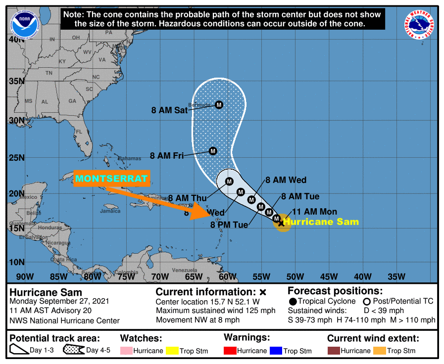
Maximum sustained winds are near 125 mph with higher gusts. Hurricane-force winds extend outward up to 30 miles from the center and tropical-storm-force winds extend outward up to 105 miles.

The minimum central pressure estimated from noaa hurricane hunter aircraft observations is 966 mb (28.53 inches).

Residents are again asked to closely monitor the progress of Hurricane Sam.The next advisory will be after 5 pm today.

FORECASTER LENARD JOSIAH
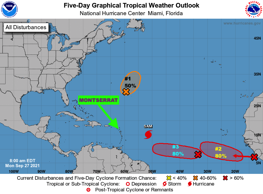
TROPICS WATCH: THE TWO (2) TROPICAL DISTURBANCES, FOLLOWING BEHIND HURRICANE SAM, COULD BECOME TROPICAL DEPRESSIONS THIS WEEK; DMCA MONITORS CLOSELY!

Monday, September 27, 2021: In addition to Hurricane Sam, The Disaster Management Coordination Agency is monitoring two (2) tropical disturbances in the Atlantic, both with high chances of becoming tropical cyclones in 5 days.

Disturbance 2 located several hundred miles southwest of the Cabo Verde Islands is expected to become a tropical depression in a few days expected,while Disturbance 3, moving offshore the west coast of Africa and into the far eastern tropical Atlantic is likely to develop into a tropical depressionin a few days. 

The National Hurricane Center issued the following advisories on the disturbances:

Tropical Disturbance 2 is located several hundred miles southwest of the Cabo Verde Islands.  Environmental conditions are forecast to be conducive for further development of this disturbance, and a tropical depression is likely to form in a few days while it moves westward to west-northwestward at 5 to 10 mph over the central tropical Atlantic. Formation chance through 48 hoursis 40%. Formation chance through 5 daysis 80%

Tropical Disturbance 3 is moving offshore the west coast of Africa and into the far eastern tropical Atlantic.  Upper-level winds are forecast to be conducive for gradual development, and a tropical depression is likely to form in a few days while the system moves westward to westnorthwestward at 10 to 15 mph over the far eastern tropical Atlantic. Formation chance through 48 hours is 40%. Formation chance through 5 days is 80%.

The Disaster Management Coordination Agency, DMCA will continue to closely monitor Hurricane Sam and Tropical Disturbances 2& 3 and  provide regular updates as new information is released from the NHC.

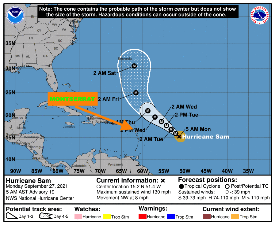
5 AM UPDATE: Hurricane Sam is expected to remain a Major Hurricane for the next several days, And is still Expected to Pass at A Safe Distance Away from Montserrat!

Also, A Tropical Cyclone Alert Remains in Effect for Montserrat; Residents urged to remain vigilant and continue to monitor of the progress of this Category 4 Hurricane.

According to the 5AM Tropical Cyclone Statement issued by the Antigua and Barbuda Meteorological Services on Monday September 27, 2021, it states that based on current information and analysis, Hurricane Sam is still expected to pass at a safe distance away from Montserrat between Tuesday and Wednesday with little or no wind and weather impact to the island. Swells associated with Sam could impact coastal areas as early as Wednesday to produce dangerous surfs and rip currents.

The threat level remains low. However any significant shift to the south-west could bring the cyclone closer to the islands which include Montserrat and elevate the threat level. Hence the need for residents to stay alert and vigilant in monitoring the progress of Hurricane Sam.

At 5 am, the center of hurricane sam was located near latitude 15.2 north, longitude 51.4 west or about 700 miles east-southeast of Antigua and Barbuda.

Sam is moving toward the northwest near 8 mph and this motion is expected to continue for the next few days, with an increase in forward speed beginning on Thursday.

Maximum sustained winds have decreased to near 130 mph with higher gusts. Sam is a Category 4 Hurricane on the Saffir-Simpson hurricane wind scale. Little chance in strength is expected during the next day or so. Thereafter, some slow weakening is forecast through midweek, although Sam should remain a major hurricane. Sam is a small hurricane.

Hurricane-force winds extend outward up to 30 miles from the center and tropical-storm-force winds extend outward up to 105 miles.

The estimated minimum central pressure is 952 mb (28.12 inches).

Residents are again asked to closely monitor the progress of Hurricane Sam.

The next advisory will be after 11am todayForecaster Bernell Simon

In addition to Hurricane Sam, there are two (2) other Tropical Disturbances in the Atlantic with Moderate Chances of Becoming Tropical Cyclones in 5 days; DMCA MONITORS CLOSELY!

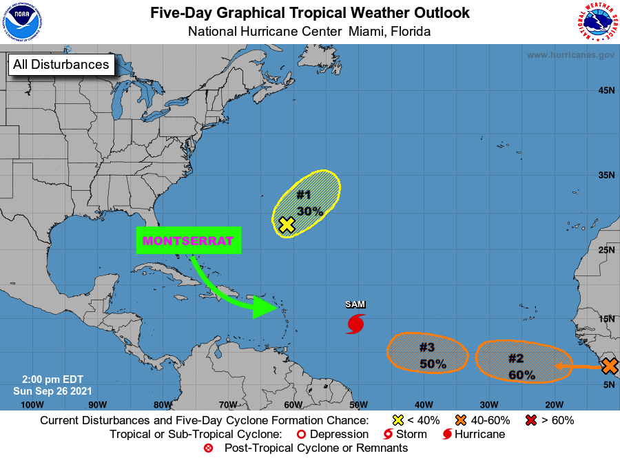
Sunday, September 26, 2021: In addition to Hurricane Sam, The Disaster Management Coordination Agency, DMCA is monitoring two (2) other tropical disturbances in the Atlantic both with moderate chances of tropical development in 5 days.

Disturbance 2 is expected to move off the west coast of Africa on Monday, and Disturbance 3 could form over the Eastern or Central Tropical Atlantic early this week!

The National Hurricane Center issued the following advisories on the disturbances:

Disturbance 2 is expected to move off the west coast of Africa on Monday. Gradual development is expected, and a tropical depression could form by midweek while the system moves westward to west-northwestward at 10 to 15 mph over the far eastern tropical Atlantic. Formation chance through 48 hours is 10%. Formation chance through 5 days is 60%.

Disturbance 3 is a broad area of low pressure expected to form over the eastern or central tropical Atlantic early this week, to the west of the tropical wave that will be moving off the coast of Africa. Environmental conditions are forecast to support some development of this disturbance, and a tropical depression could form by late this week while it moves westward at 5 to 10 mph. Formation chance through 48 hours is near 0 percent. Formation chance through 5 days is 50 percent.

.

Residents on Montserrat must continue to monitor the Tropical Atlantic in case of any changes with these systems.

The Disaster Management Coordination Agency, DMCA will continue to closely monitor Hurricane Sam and Tropical Disturbances 2 and 3 and provide regular updates as new information is released from the NHC.

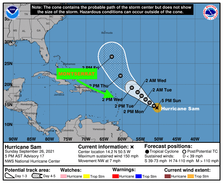
5 PM HURRICANE SAM UPDATE: A Tropical Cyclone Alert Remains in Effect for Montserrat tonight!

Residents on Montserrat should remain vigilant and continue to closely monitor this powerful and dangerous Hurricane.

According to the 5PM Tropical Cyclone Statement issued by the Antigua and Barbuda Meteorological Services, it said based on current information and analysis, Hurricane Sam is expected to pass at a safe distance away from MONTSERRAT between Tuesday and Wednesday with little or no wind impact to the islands. Therefore, there is a low threat to the island with respect to winds.

However, the statement went on to say, given the dynamic nature of tropical cyclones any shift to the south could bring Hurricane Sam closer to the island which include Montserrat; hence residents should remain vigilant and keep close and continuous monitoring of this powerful and dangerous system.

As Hurricane Sam passes, extensive impacts from swells/ surfs are expected to affect coastal areas which could lead to soil erosion and rip currents, therefore to be safe, residents will be asked to avoid these areas until the all clear is given.

At 500 pm, the center of hurricane sam was located near latitude 14.2 north, longitude 50.5 west. Hurricane Sam is moving toward the northwest near 7 mph and this motion is expected to continue for the next few days, along with a gradual increase in forward speed commencing by midweek. Maximum sustained winds have increased to near 150 mph with higher gusts. Sam is a Category 4 Hurricane on the saffir-simpson hurricane wind scale. Some fluctuations in intensity are expected during the next couple of days. Thereafter, some slow weakening is forecast.

Hurricane Sam is a small tropical cyclone. Hurricane-force winds extend outward up to 30 miles from the center and tropical-storm-force winds extend outward up to 90 miles.

The estimated minimum central pressure is 938 mb (27.70 inches).

The next advisory will be at 11 pm

Forecaster Cecil Matthew

11 AM HURRICANE SAM UPDATE: A TROPICAL CYCLONE ALERT REMAINS IN EFFECT FOR MONTSERRAT!

The Antigua and Barbuda Meteorological Services, in its 11 AM Update, says Hurricane Sam is expected to pass at a safe distance away from Montserrat between Tuesday and Wednesday with little or no wind impact to the island, therefore, there is a very low threat to MONTSERRAT with respect to winds.

However, the Meteorological Agency said given the dynamic nature of tropical cyclones any shift to the south could bring Hurricane Sam closer to Montserrat; hence the need for continuous monitoring.

It states that as the system passes extensive impacts from swells/ surfs are expected to affect coastal areas which could lead to soil erosion and rip currents, therefore, to be safe, residents will be asked to avoid these areas until the all clear is given.

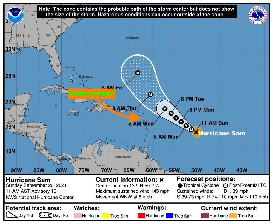
At 11 am, the centre of Hurricane Sam was located near latitude 13.9 north, longitude 50.2 west or about 803 miles east- southeast of the Leeward Islands which include Montserrat. Sam is moving towards the west-northwest at near 8 mph and this general motion is expected to continue today. A turn towards the northwest is expected on Monday, followed by a northwestward motion forecast to continue through to midweek.

Maximum sustained winds are near 145 mph with higher gusts. Sam is a category 4 hurricane on the Saffir Simpson hurricane wind scale. Some fluctuations in intensity are expected during the next day or so. Thereafter, some slow weakening is forecast. Hurricane-force winds extend outward up to 30 miles from the center and tropical-storm-force winds extend outward up to 90 miles.

The estimated minimum central pressure is 943 mb (27.85 inches).

Residents are encouraged to continue to monitor the progress of Hurricane Sam.

The next advisory on this system will be issued after 5 pm today.

FORECASTER PATRICE EDWARDS

A Tropical Cyclone Alert Remains In Effect For Montserrat – Hurricane Sam is expected to pass at a safe distance away from Montserrat between Tuesday and Wednesday with little or no Wind Impact to the island!

However, the Antigua and Barbuda Meteorological Services is reminding residents that given the dynamic nature of tropical cyclones any shift to the south could bring Hurricane Sam closer to the islands which include Montserrat, hence individuals should continue to monitor the progress of Hurricane Sam.

In its 5:27 AM tropical cyclone statement on SUNDAY SEPTEMBER 26, 2021, the Meteorological Services said based on current information and analysis, Hurricane Sam is expected to pass at a safe distance away from MONTSERRAT between Tuesday and Wednesday with little or no wind impact to the island. therefore, there is a very low threat to the islands which MONTSERRAT with respect to winds.

However, given the dynamic nature of tropical cyclones any shift to the south could bring the cyclone closer to the islands WHICH INCLUDE MONTSERRAT, hence the need for continuous monitoring.As the system passes extensive impacts from swells/ surfs are expected to affect coastal areas which could lead to soil erosion and rip currents therefore to be safe, residents will be asked to avoid these areas until the all clear is given.

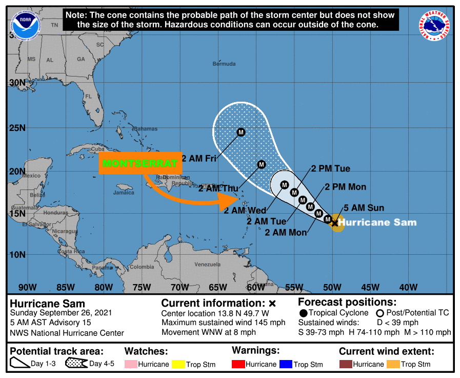
At 5 am, the center of hurricane sam was located near latitude 13.8 north, longitude 49.7 west or about 837 miles east-southeast of the leeward islands. Hurricane Sam is slowly moving towards the west-northwest near 8 mph. This general motion is expected to continue today, followed by a turn toward the northwest on monday. Then, a northwestward motion is forecast to continue through midweek.

Maximum sustained winds are near 145 mph with higher gusts. Hurricane Sam is a category 4 hurricane on the saffir-simpson hurricane wind scale. Some fluctuations in intensity are expected during the next day or so. Thereafter, some slow weakening is forecast. Sam is a small hurricane. Hurricane-force winds extend outward up to 30 miles from the center and tropical-storm-force winds extend outward up to 90 miles.The estimated minimum central pressure is 943 mb (27.85 inches).

The Disaster Management Coordination Agency is urging residents on Montserrat to continue to monitor the progress of Hurricane Sam.

The next advisory on this system will be issued after 11 am today.

FORECASTER LETITIA HUMPHREYS

SATURDAY EVENING UPDATE: HURRICANE SAM IS NOW A DANGEROUS CATEGORY 4 STORM WITH MAXIMUM SUSTAINED WINDS OF NEAR 140 MILES PER HOUR WITH EVEN HIGHER GUSTS!AND, A TROPICAL CYCLONE ALERT REMAINS IN EFFECT FOR MONTSERRAT; RESIDENTS SHOULD CONTINUE TO MONITOR THE PROGRESS OF HURRICANE SAM.

AND, A TROPICAL CYCLONE ALERT REMAINS IN EFFECT FOR MONTSERRAT; RESIDENTS SHOULD CONTINUE TO MONITOR THE PROGRESS OF HURRICANE SAM.

A Tropical Cyclone Alert means that, in this case, a hurricane is in our monitored area. Watches and Warnings are not required at this time, but may be necessary in the next 72 hours.

In a tropical cyclone statement issued on Saturday September 25, 2021 at 5: 43PM, the Antigua and Barbuda Meteorological Services said based on current information and analysis, Hurricane Sam, which is a small, but dangerous” hurricane is expected to pass at a safe distance away from MONTSERRAT between Tuesday and Wednesday with little or no impact to the island with respect to winds, cloudiness and showers.

Therefore, there is a very low threat to the island. However given the dynamic nature of tropical cyclones any shift to the south could bring the cyclone closer to the islands. Hence the need for continuous monitoring.

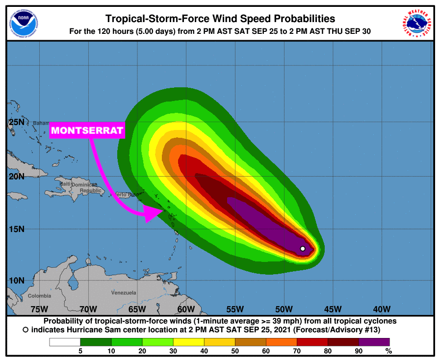
At 5 pm, the center of hurricane sam was located near latitude 13.3 north, longitude 48.5 west or about 924 miles east-southeast of the leeward islands. Sam is moving toward the west-northwest near 10 mph. A slower motion to the west-northwest is expected over the weekend, followed by a turn to the northwest on Monday.

Maximum sustained winds have increased to near 140 mph with higher gusts. Sam is a category 4 hurricane on the saffir-simpson hurricane wind scale. Additional strengthening is expected through tonight.

The estimated minimum central pressure is 960 mb (28.35 inches).

Residents should continue to monitor the progress of Hurricane Sam.

The next advisory on this system will be issued after 11 pm tonight.

FORECASTER ORVIN PAIGE

A TROPICAL CYCLONE ALERT REMAINS IN EFFECT FOR MONTSERRAT AS HURRICANE SAM IS NOW A MAJOR HURRICANE; RESIDENTS IN MONTSERRAT ARE URGED TO CONTINUE TO CLOSELY MONITOR THE PROGRESS OF THIS POTENTIALLY DANGEROUS SYSTEM.

According to a statement issued by the Antigua and Barbuda Meteorological Services on Saturday September 25, 2021, at 11:10 am, it states that based on current information and analysis, the forecast track of Hurricane Sam places the system sufficiently north of the area to spare the islands of tropical cyclone wind impacts; as a result, the system poses a low threat to the islands at this time.

It also adds that, notwithstanding, it is also necessary to mention that given the dynamic nature of tropical cyclones, shifts in the forecast track are possible which could bring the system closer to the area resulting in an increased threat of tropical cyclone impacts to the islands which include Montserrat.Hence, residents in Montserrat are urged to continue to closely monitor the progress of this potentially dangerous system.

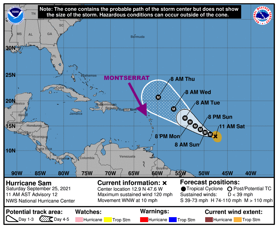
At 11 am, the center of Hurricane Sam was located near latitude 12.9 north, longitude 47.6 west or about 1095 miles east-southeast of the leeward islands. Sam is moving toward the west-northwest near 10 mph. A slower motion to the west-northwest is expected over the weekend, followed by a turn to the northwest on Monday. Maximum sustained winds have increased to near 120 mph with higher gusts.

Sam is a category 3 hurricane on the Saffir Simpson hurricane wind scale. Additional strengthening is expected over the next day or so, and Sam is forecast to become a category 4 hurricane by Sunday. Some fluctuations in the hurricane’s intensity are possible early next week. Sam is a small hurricane. Hurricane-force winds extend outward up to 25 miles from the center and tropical-storm-force winds extend outward up to 105 miles.

The estimated minimum central pressure is 960 mb (28.35 inches).

The next advisory will be at 5 pm

Forecaster Cecil Matthew

MONTSERRAT REMAINS UNDER A TROPICAL CYCLONE ALERT FOR HURRICANE SAM; RESIDENTS ON MONTSERRAT URGED TO CONTINUE TO CLOSELY MONITOR THE PROGRESS OF THIS POTENTIALLY DANGEROUS SYSTEM.

The Antigua and Barbuda Meteorological Services in its 5:10 Hurricane Sam Alert statement, on Saturday September 25, 2021, said based on current information and analysis, the forecast track of Hurricane Sam places the system sufficiently north of the area to spare Montserrat from tropical cyclone wind impacts.Hence, Hurricane Sam poses a very low threat to Montserrat at this time.

It went on to say, notwithstanding, it is also necessary to mention that given the dynamic nature of tropical cyclones, shifts in the forecast track are possible which could bring the system closer to the area resulting in an increased threat of tropical cyclone impacts to the islands.

Therefore, residents here on Montserrat are urged to continue to closely monitor the progress of this potentially dangerous system.

At 5 AM, The eye of hurricane sam was located near latitude 12.8 north, longitude 46.7 west or 1050 miles east-southeast of the leewards which includes Montserrat.Sam continues to move towards the west-northwest near 13 mph. A slower motion to the west-northwest is expected over the weekend, followed by a turn to the northwest on Monday.

Maximum sustained winds have increased to near 110 mph with higher gusts. Rapid intensification is forecast as sam is in a favorable environment and sam is expected to become a major hurricane later today.

No watches or warnings area required at this time; however residents should guard against complacency and be prepared to activate their hurricane preparedness plans in the event they become necessary.

The next update will be issued at 11 am today.

FORECASTER LETITIA HUMPHREYS