A Tropical Cyclone Alert remains in effect for Montserrat.
A tropical cyclone alert means, in this case, that Hurricane Erin is within our monitored area but not close enough for a watch or warning to be issued.
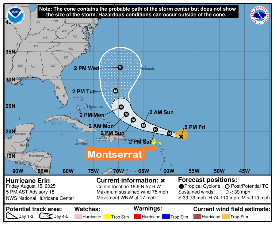
The best forecast remains for the centre of Erin to pass northeast, then north of Montserrat. The chance of storm-force winds reaching Montserrat is low. However, any shift towards the islands could bring the core of the system uncomfortably close to the islands late tonight into Sunday. The risk from swells will rise; hence, those near coastal areas should be aware. Other hazards, such as heavy rainfall accompanied by strong gusty winds, are also possible within outer rain bands.
Residents on Montserrat should monitor the progress of this cyclone and, to be safe, be prepared for the rest of the hurricane season.
At 5:00 pm, the center of Hurricane Erin was located near latitude 18.9 north, longitude 57.6 west or 365 miles east of the northern Leeward Islands.
Erin is moving toward the west-northwest near 17 mph. This motion is expected to continue into the weekend with some decrease in forward speed. On the current forecast track, the center of Erin is likely to pass just north of the northern Leewards during the weekend
Maximum sustained winds are near 75 mph with higher gusts. Steady to rapid strengthening is expected during the next few days, and Erin is forecast to become a major hurricane during this weekend.
Hurricane-force winds extend outward up to 25 miles from the center, and tropical-storm-force winds extend outward up to 115 miles mainly to the north of the center.
The minimum central pressure is 993 mb.
Swells from Erin would cause marine conditions to deteriorate, and mariners are advised to remain in port and ensure that their vessels are safely moored.
Rainfall amounts of 2 -4 inches are possible, which could cause flooding in low-lying and flood-prone areas; hence, residents should move to a safer location.
Forecaster Bernell Simon