…TROPICAL STORM CONDITIONS POSSIBLE ACROSS PORTIONS OF THE NORTHERN LEEWARD ISLANDS WHEN JERRY PASSES NEARBY LATE THURSDAY INTO THURSDAY NIGHT…
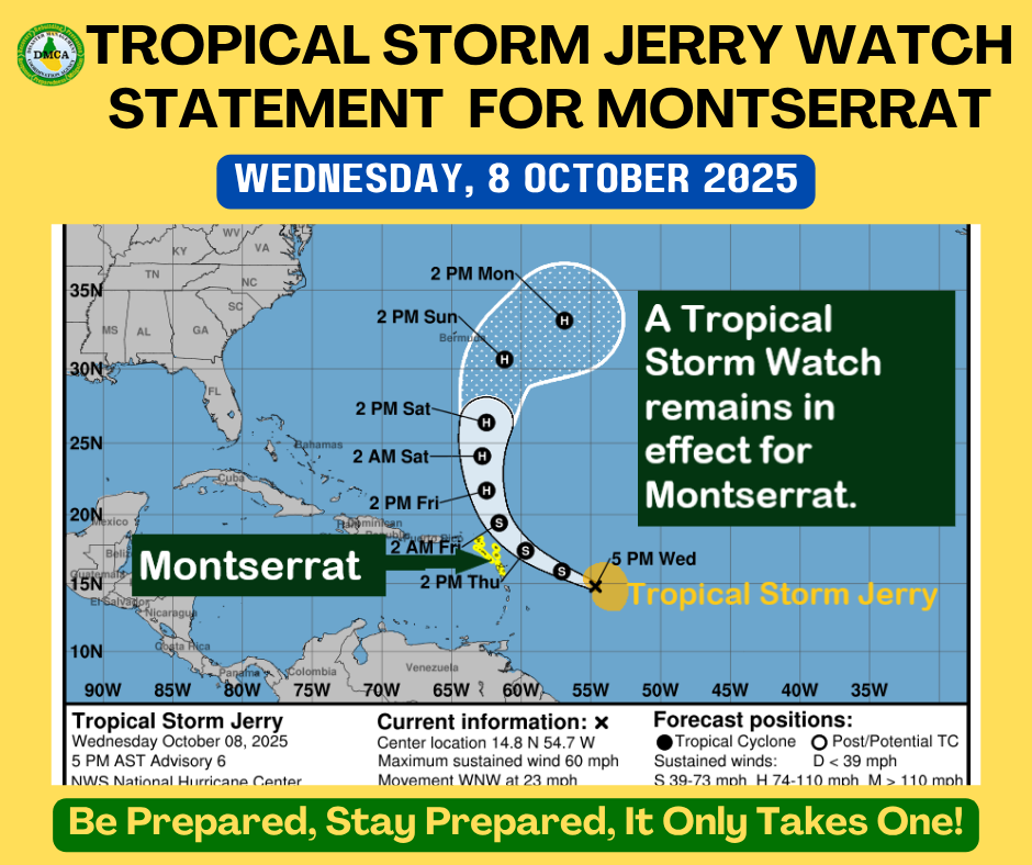
A Tropical Storm Watch remains in effect for Montserrat.
A Tropical Storm Watch means that tropical-storm conditions pose a possible threat to the specified area within 48 hours.
At 5:00 PM, the center of Tropical Storm Jerry was located near latitude 14.8° North, longitude 54.7° West, or about 449 miles east-southeast of Montserrat.
Jerry is moving toward the west-northwest at 23 mph. This general motion is expected to continue through Thursday. A northwestward motion at a slower forward speed should begin Thursday night, followed by a northward motion Friday night into Saturday.
On the forecast track, the center of Jerry is expected to pass near or to the northeast of the northern Leeward Islands late Thursday into Thursday night.
Maximum sustained winds are near 60 mph, with higher gusts. Gradual strengthening is forecast over the next few days, and Jerry could become a hurricane late this week or over the weekend.
Tropical-storm-force winds extend outward up to 175 miles from the center.
The estimated minimum central pressure is 1000 mb.
POTENTIAL IMPACTS FOR MONTSERRAT
The core of Jerry is expected to pass near or to the north of the northern Leeward Islands late Thursday into Friday, causing gusty conditions mainly in showers.
Rainfall totals of up to 3 inches are possible during the passage of Jerry, which could cause localized flooding, especially in low-lying and flood-prone areas.
Swells generated by Jerry are expected to reach the Leeward Islands on Thursday, producing hazardous surf and life-threatening rip currents.
?? Mariners are advised to remain in port until conditions improve.
At this time, no specific action is required of residents other than to closely monitor the progress of Jerry and ensure that preparedness plans are in place.
The next advisory will be issued at 11:00 PM.
Forecaster: Orvin Paige