Antigua and Barbuda Meteorological Services
Thursday, October 9, 2025
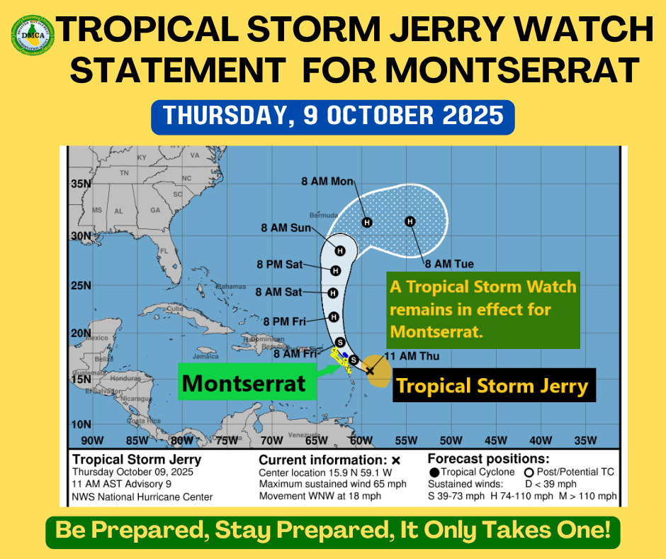
This statement is for Montserrat
…Tropical storm conditions possible over portions of the northern Leeward Islands when Jerry passes nearby late Thursday and Thursday night…
A Tropical Storm Watch remains in effect for Montserrat.
A Tropical Storm Watch means that tropical storm conditions pose a possible threat to the specified area within 48 hours.
At 11:00 AM AST (1500 UTC), the center of Tropical Storm Jerry was located near latitude 15.9° North, longitude 59.1° West, or about 215 miles east-southeast of Montserrat.
Jerry is moving toward the west-northwest near 18 mph, and this general motion is expected to continue through today. A turn toward the northwest is expected later today, followed by a slightly slower northward motion Friday and Saturday. On the forecast track, the center of Jerry is expected to pass near or to the northeast of the northern Leeward Islands later today and tonight.
Maximum sustained winds are near 65 mph with higher gusts. Gradual strengthening is forecast during the next few days, and Jerry could become a hurricane by late Friday or Saturday.
Tropical-storm-force winds extend outward up to 175 miles, mainly east of the center.
The estimated minimum central pressure is 999 mb (29.50 inches).
Based on the latest observations and analysis, the core of Jerry is expected to be near or north of the northern Leeward Islands later today into Friday, producing gusty conditions mainly in showers.
Rainfall totals of 2 to 4 inches are possible during the passage of Jerry, which could cause minor to moderate flooding, particularly in low-lying and flood-prone areas.
Swells generated by Jerry are expected to reach the Leeward Islands this afternoon. These swells are likely to cause life-threatening surf and rip current conditions; mariners are strongly advised to remain in port.
Residents should continue to monitor the progress of Jerry and be prepared for the possibility of storm conditions.
Repeating the 11:00 AM position:
Latitude 15.9°N, Longitude 59.1°W.
Movement toward the west-northwest near 18 mph.
Maximum sustained winds 65 mph.
Minimum central pressure 999 mb.
The next advisory will be issued at 5:00 PM.
Forecasters: Letitia Humphreys / Charissa Humphreys