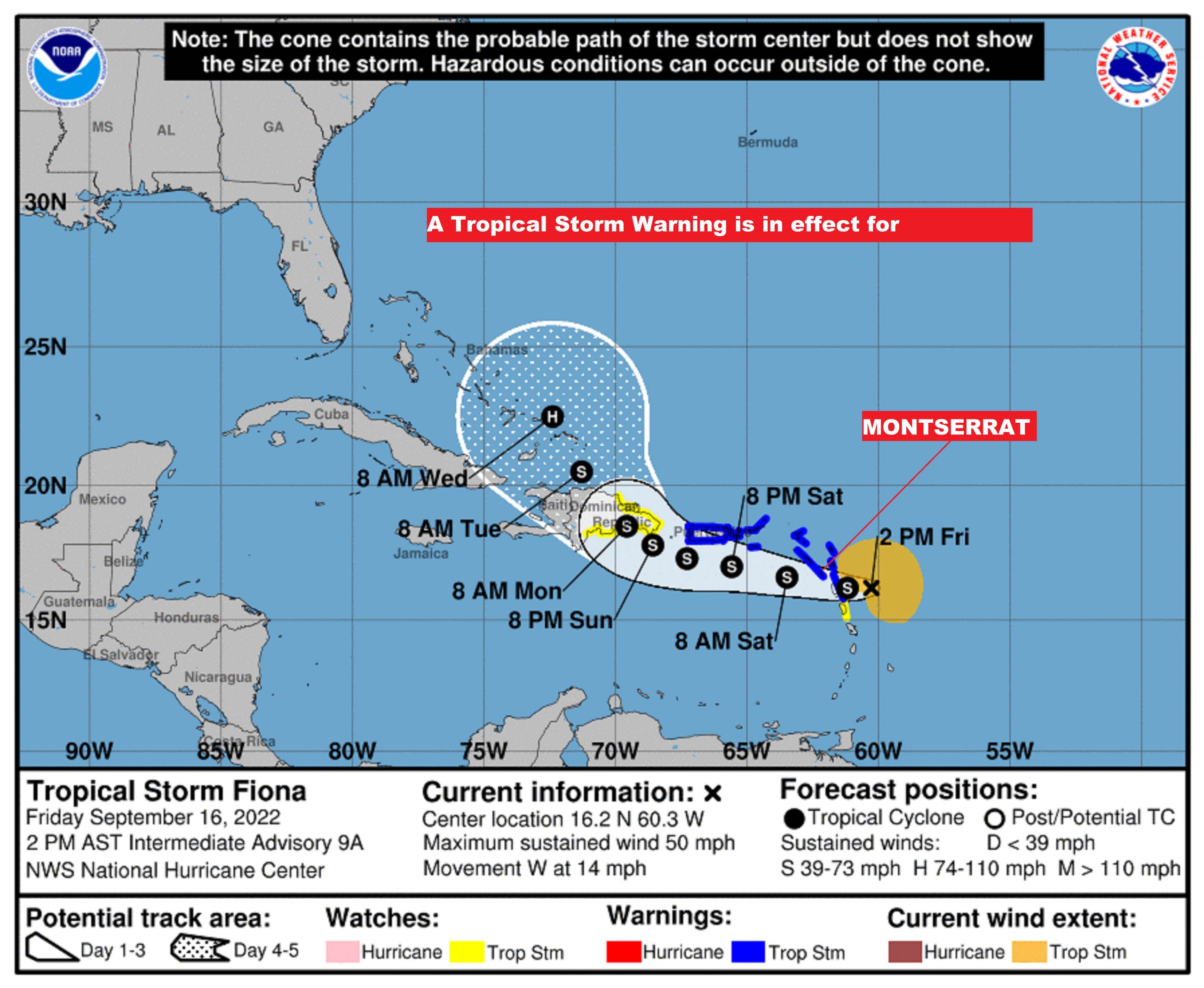
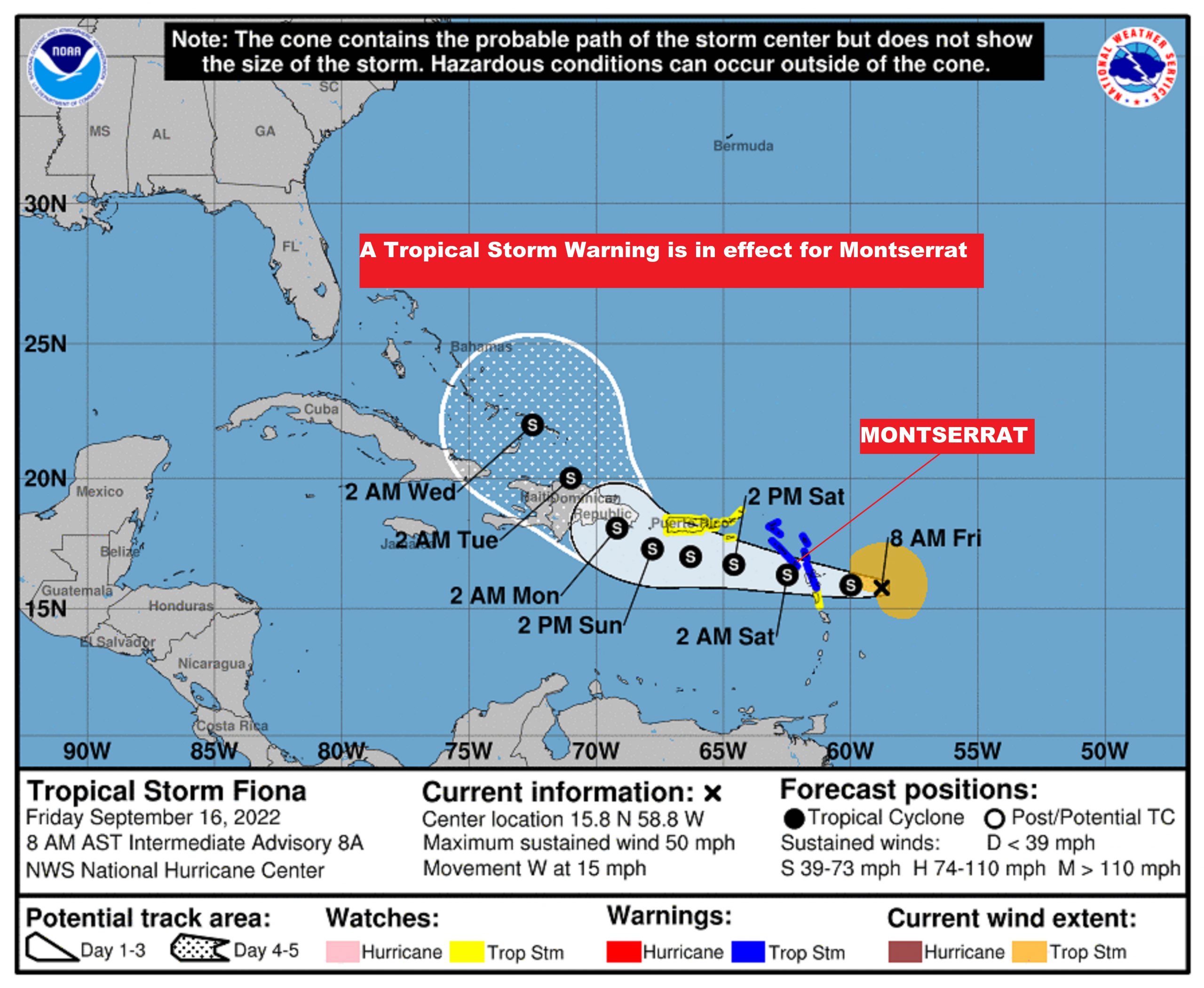
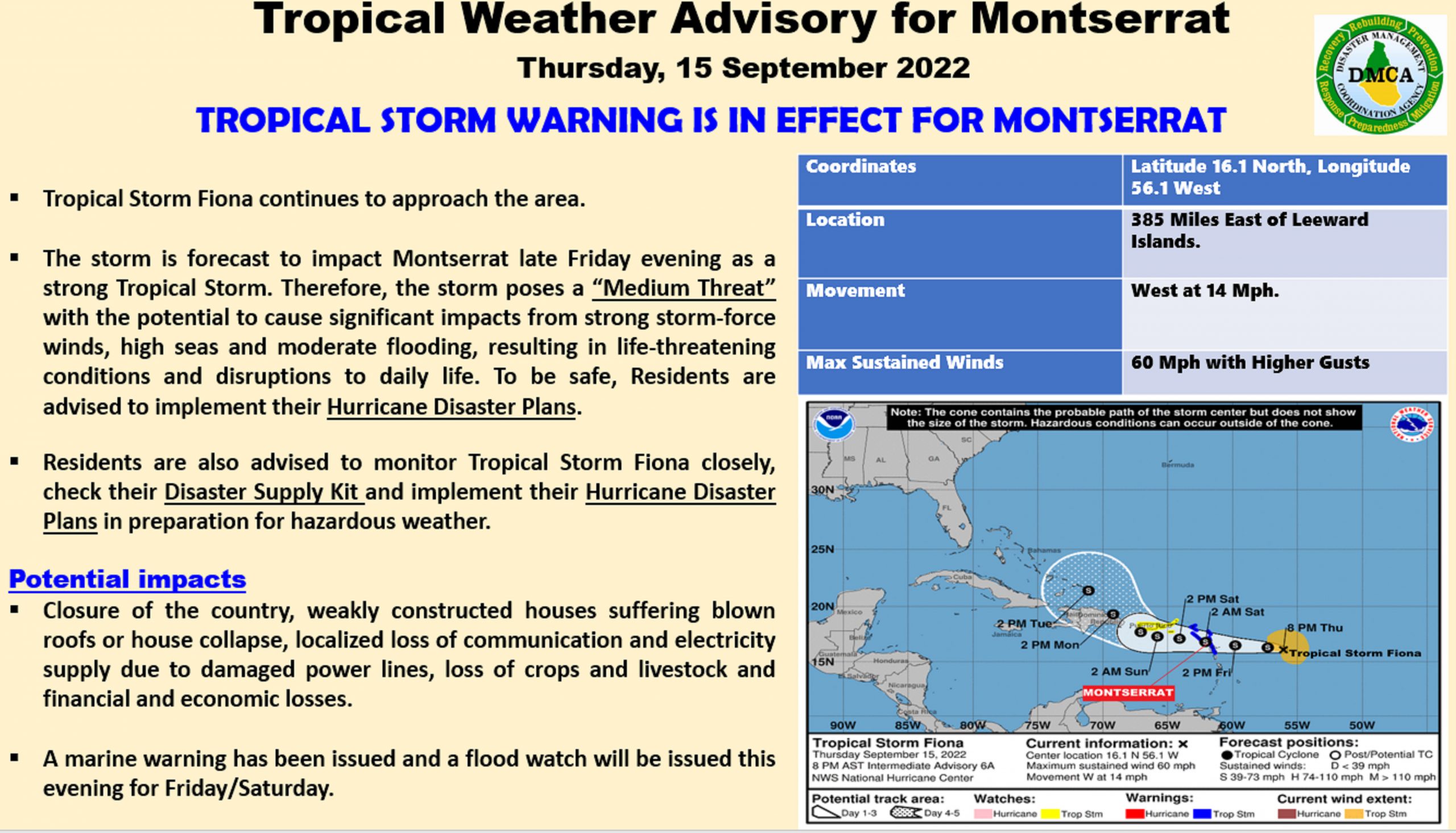
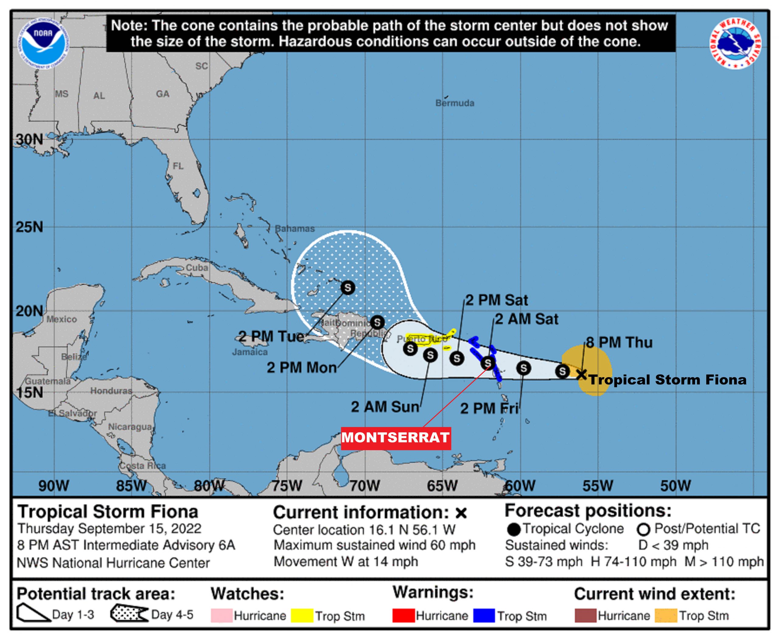
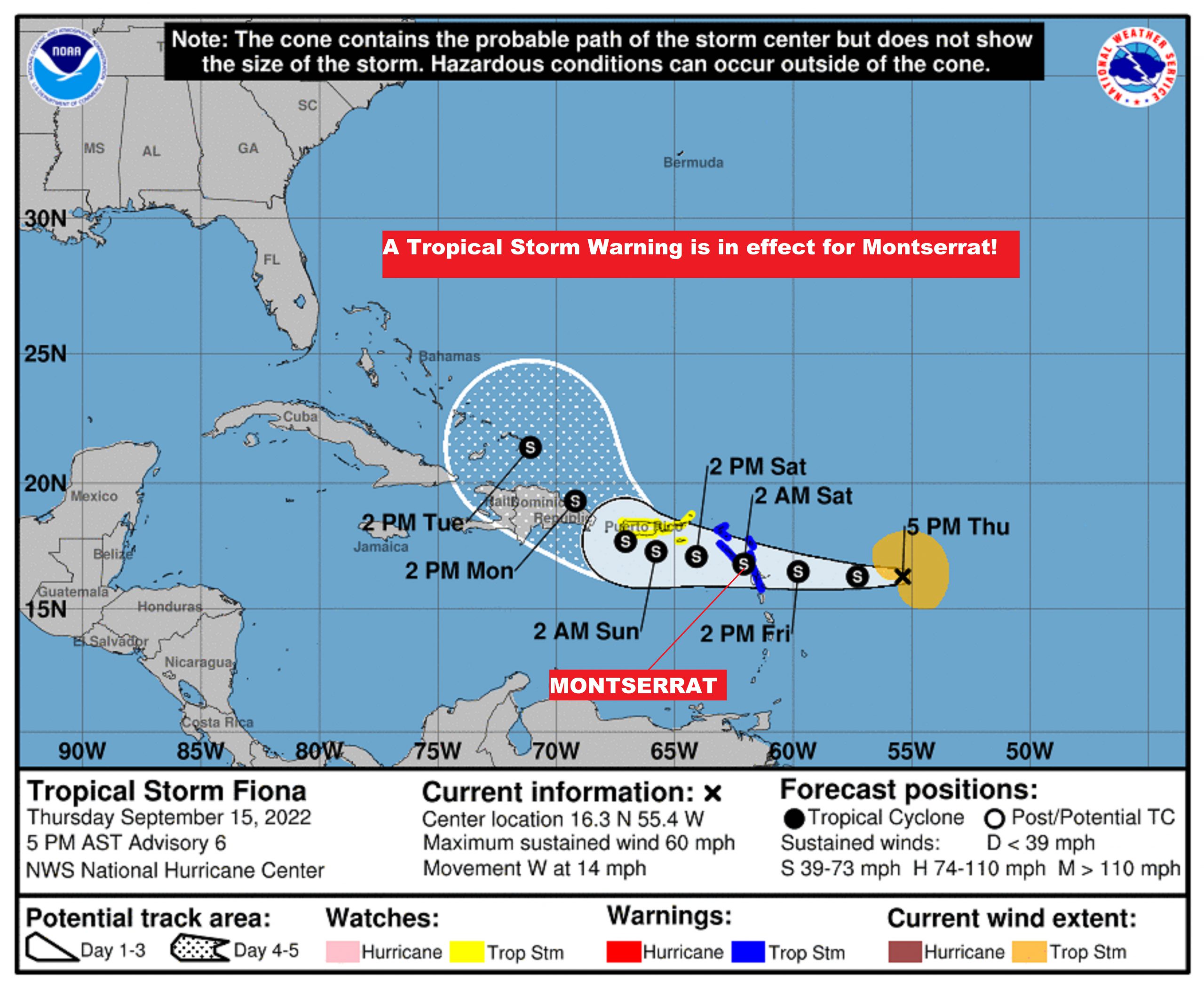
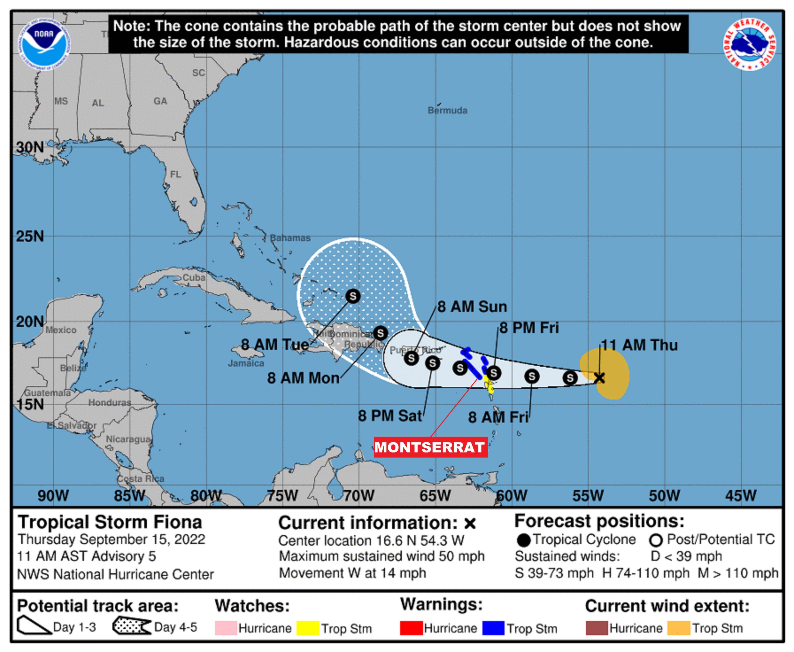
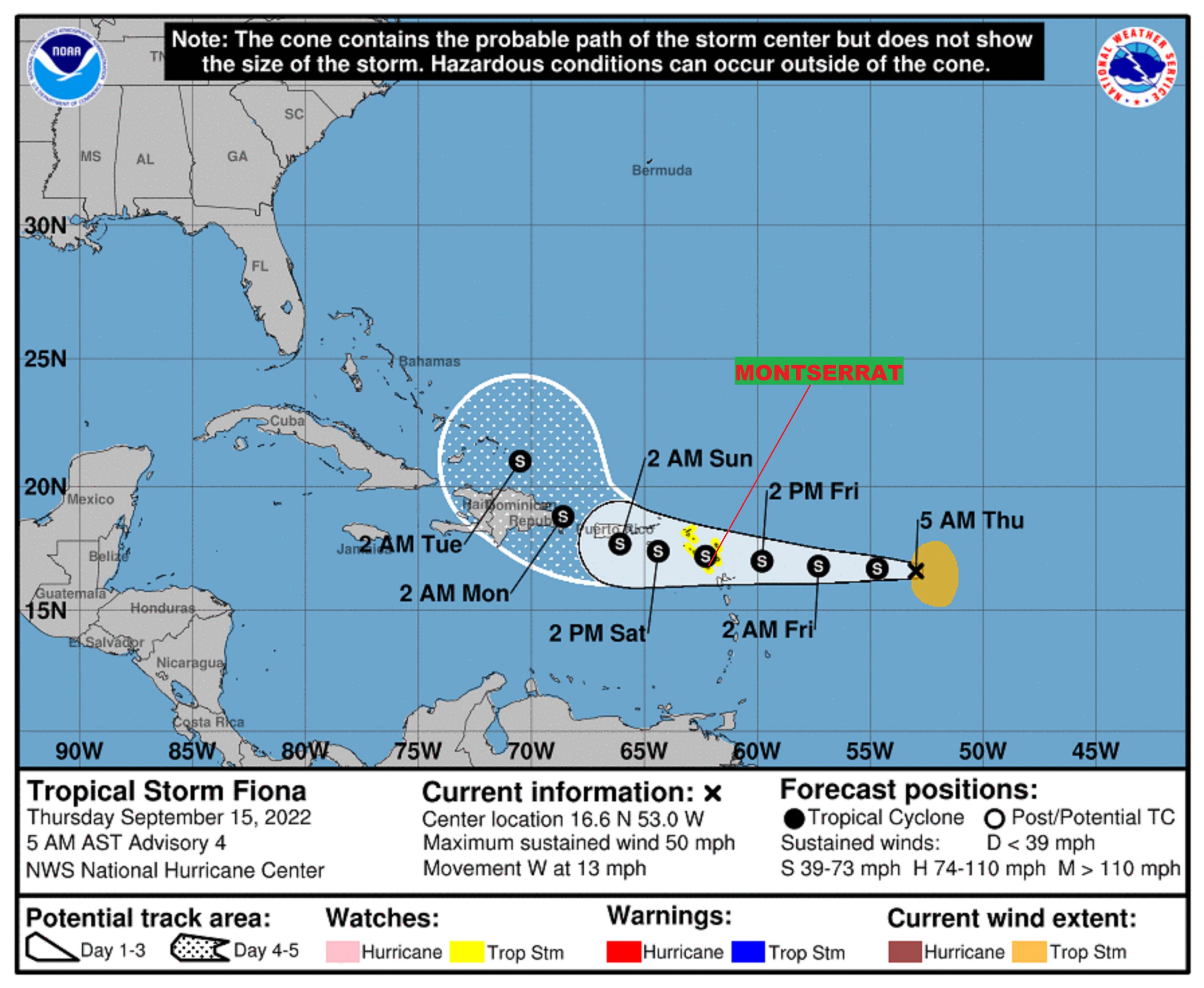
A TROPICAL STORM WATCH IS NOW IN EFFECT FOR MONTSERRAT, AND A TROPICAL STORM WARNING IS POSSIBLE IN THE NEXT 24 HOURS!

ALL RESIDENTS ARE URGED TO MONITOR THE MOVEMENT OF TROPICAL STORM FIONA CLOSELY AND TAKE ACTION TO PROTECT LIFE AND PROPERTY.

ACCORDING TO A STATEMENT ISSUED BY THE ANTIGUA AND BARBUDA METEOROLOGICAL SERVICES TODAY THURSDAY, 15 SEPTEMBER, 2022, A TROPICAL STORM WATCH MEANS THAT TROPICAL STORM CONDITIONS POSE A POSSIBLE THREAT TO THE AREA WITHIN 48 HOURS.

AT 5 AM, THE CENTRE OF TROPICAL STORM FIONA WAS LOCATED NEAR LATITUDE 16.6 NORTH, LONGITUDE 53.0 WEST OR ABOUT 529 MILES EAST OF MONTSERRAT.

FIONA IS MOVING TOWARD THE WEST AT 13 MILES PER HOUR. THIS GENERAL MOTION IS EXPECTED TO CONTINUE DURING THE NEXT FEW DAYS. ON THE FORECAST TRACK, THE CENTRE OF FIONA IS EXPECTED TO MOVE THROUGH THE LEEWARD ISLANDS LATE FRIDAY AND FRIDAY NIGHT, AND BE NEAR THE VIRGIN ISLANDS THIS WEEKEND.

SATELLITE-DERIVED WIND DATA INDICATE THAT MAXIMUM SUSTAINED WINDS HAVE INCREASED TO NEAR 50 MPH WITH HIGHER GUSTS. SOME SLOW STRENGTHENING IS POSSIBLE OVER THE NEXT FEW DAYS.

TROPICAL STORM FORCE WINDS EXTEND UP TO 140 MILES EAST OF THE CENTRE.

THE ESTIMATED MINIMUM CENTRAL PRESSURE IS 1002 MB OR 29.59 INCHES.

BASED ON THE LATEST OBSERVATION AND ANALYSIS, TROPICAL STORM CONDITIONS ARE POSSIBLE ACROSS PORTIONS OF THE NORTHERN LEEWARD ISLANDS BY FRIDAY.

THERE ARE STILL UNCERTAINTIES AS TO THE EVENTUAL STRENGTH OF FIONA WHEN IT APPROACHES THE AREA ON FRIDAY, GIVEN THAT ATMOSPHERIC CONDITIONS ARE ONLY MARGINALLY CONDUCIVE FOR FURTHER DEVELOPMENT.

ALSO, SHOWERS ASSOCIATED WITH THE SYSTEM ARE EXPECTED TO MOVE ACROSS THE ISLANDS IN THE NEXT 24-36 HOURS. RAINFALL TOTALS OF 3-5 INCHES ARE FORECAST TO OCCUR OVER PORTIONS OF THE AREA DURING THE PASSAGE OF FIONA, WITH ISOLATED AMOUNTS OF UP TO 8 INCHES IN SOME PLACES. WITH THIS TYPE OF RAINFALL, RESIDENTS IN LOW-LYING AND FLOOD-PRONE AREAS SHOULD BE PREPARED TO MOVE TO HIGHER GROUNDS AS MODERATE FLASH FLOODING ARE POSSIBLE. RESIDENTS NEAR SLOPES SHOULD PREPARE TO GUARD AGAINST MUDSLIDES.

MARINERS SHOULD STAY IN PORT AND SEEK SAFE ANCHORAGE. SEAS WILL START TO DETERIORATE SIGNIFICANTLY BY FRIDAY AND WILL PEAK NEAR 10 FEET OR GREATER DURING THE PASSAGE OF THE STORM.

ALL RESIDENTS ARE URGED TO MONITOR THE MOVEMENT OF TROPICAL STORM FIONA CLOSELY AND TAKE ACTION TO PROTECT LIFE AND PROPERTY.

A TROPICAL STORM WARNING IS POSSIBLE IN THE NEXT 24 HOURS.

THE NEXT COMPLETE ADVISORY WILL BE AT 11 AM ECT.

FORECASTER JALEEL JACOBS

Montserrat is now under a Tropical Storm Watch – Tropical Depression Seven is now Tropical Storm Fiona

Yellow Hill – Thursday, 15 September 2022 – The Disaster Management Coordination Agency, DMCA continues to closely monitor Tropical Storm Fiona, and will provide regular updates via ZJB Radio and Social Media Platforms.

Residents are urged to monitor Tropical Storm Fiona closely, activate their emergency plans now, assess their risks for flooding and leaking, and remove all loose objects from outdoors, especially construction sites.

At 500 AM, the center of Tropical Storm Fiona was located near latitude 16.6 North, longitude 53.0 West. Fiona is moving toward the west near 13 mph (20 km/h), and this general motion is expected to continue for the next several days. On the forecast track, the center of Fiona is forecast to move through the Leeward Islands late Friday and Friday night, and move near the Virgin Islands and Puerto Rico this weekend.

Maximum sustained winds are near 50 mph (85 km/h) with higher gusts. Little change in strength is forecast during the next few days.

Tropical-storm-force winds extend outward up to 140 miles (220 km) east of the center.

The estimated minimum central pressure is 1002 mb (29.59 inches).

HAZARDS AFFECTING LAND
———————-
WIND: Tropical storm conditions are possible across portions of the northern Leeward Islands by Friday night, where a Tropical Storm Watch is in effect.

RAINFALL: Fiona is expected to produce total rainfall accumulations of 3 to 6 inches with isolated higher amounts across the northern Leeward Islands, the British and U.S. Virgin Islands, Puerto Rico and eastern Hispaniola. These rains may produce flash and urban flooding, along with isolated mudslides in areas of higher terrain.

SURF: Swells generated by Fiona are expected to begin affecting the northern Leeward Islands by early Friday. These swells could cause life-threatening surf and rip current conditions. Please consult products from your local weather office.

The Disaster Management Coordination Agency, DMCA is encouraging residents and visitors to continue to monitor the DMCA and be prepared.

A TROPICAL CYCLONE ALERT REMAINS IN EFFECT FOR MONTSERRAT FOR TROPICAL DEPRESSION 7 – THE SYSTEM IS FORECAST TO BECOME A TROPICAL STORM TONIGHT OR THURSDAY.

ACCORDING TO A TROPICAL CYCLONE ALERT STATEMENT ISSUED BY THE ANTIGUA AND BARBUDA METEOROLOGICAL SERVICES THIS EVENING, A TROPICAL CYCLONE ALERT MEANS THAT, IN THIS CASE, A TROPICAL DEPRESSION IS IN OUR MONITORED AREA OF CONCERN.

BASED ON THE LATEST INFORMATION AND ANALYSIS, THERE IS AN INCREASING THREAT OF TROPICAL CYCLONE IMPACTS AFFECTING THE LEEWARDS WHICH INCLUDE MONTSERRAT DURING THE WEEKEND; HOWEVER, THERE REMAINS SOME UNCERTAINTY OF THE MAGNITUDE OF THE IMPACTS AT THIS TIME; HENCE, RESIDENTS ARE ADVISED TO CONTINUE TO CLOSELY MONITOR THE PROGRESS OF THIS SYSTEM.

AT 500 PM, THE CENTER OF TROPICAL DEPRESSION SEVEN WAS LOCATED NEAR LATITUDE 16.8 NORTH, LONGITUDE 50.5 WEST OR 750 MILES EAST OF THE LEEWARDS AND 935 MILES EAST &8211; SOUTHEAST OF THE BVI.

THE DEPRESSION IS MOVING TOWARD THE WEST NEAR 13 MPH (20 KM/H), AND THIS GENERAL MOTION IS EXPECTED TO CONTINUE DURING THE NEXT FEW DAYS.

MAXIMUM SUSTAINED WINDS ARE NEAR 35 MPH (55 KM/H) WITH HIGHER GUSTS. SOME GRADUAL STRENGTHENING IS FORECAST DURING THE NEXT DAY OR SO, AND THE DEPRESSION IS FORECAST TO BECOME A TROPICAL STORM TONIGHT OR THURSDAY.

THE ESTIMATED MINIMUM CENTRAL PRESSURE IS 1008 MB (29.77 INCHES).

ON ITS FORECAST TRACK, THE CYCLONE WILL LIKELY BE NEAR THE ISLANDS THIS WEEKEND, AS A MINIMAL TROPICAL STORM BRINGING POSSIBLE IMPACTS OF GUSTY WINDS, HEAVY RAINFALL AND ROUGH SEAS.

CURRENTLY, THERE ARE NO WATCHES OR WARNINGS IN EFFECT AT THIS TIME; BUT WILL LIKELY BE REQUIRED LATER TONIGHT OR EARLY TOMORROW; HENCE, RESIDENTS ARE ADVISED TO MONITOR THE PROGRESS OF THE SYSTEM.

THE NEXT ADVISORY WILL BE AT AROUND 11 PM OR SOONER IF NEEDED.

FORECASTER BERNELL SIMON/LENARD JOSIAH

TROPICAL DISTURBANCE AL96 HAS BECOME TROPICAL DEPRESSION SEVEN AND CONTINUES TO APPROACH THE AREA.

AND, A TROPICAL CYCLONE ALERT IS IN EFFECT FOR MONTSERRAT!

ACCORDING TO A TROPICAL CYCLONE ALERT STATEMENT ISSUED BY THE ANTIGUA AND BARBUDA METEOROLOGICAL SERVICES AT 11:30 AM WEDNESDAY, 14 SEPTEMBER 2022, A TROPICAL CYCLONE ALERT MEANS THAT, IN THIS CASE, A TROPICAL DEPRESSION IS IN OUR MONITORED AREA OF CONCERN. A TROPICAL STORM WATCH MAY BE REQUIRED LATER.

IT IS A BIT TOO EARLY TO DETERMINE THE FULL IMPACTS OF THE SYSTEM, IF ANY, WITH HIGH CERTAINTY. HOWEVER, TROPICAL DEPRESSION SEVEN IS FORECAST TO BE IN THE VICINITY ON FRIDAY AS A MINIMAL TROPICAL STORM. THEREFORE, IT POSES AN ELEVATED THREAT WITH THE POTENTIAL TO CAUSE LIMITED IMPACTS FROM STORM-FORCE WINDS, HIGH SEAS AND MINOR FLOODING, RESULTING IN LIFE-THREATENING CONDITIONS AND MINOR DISRUPTIONS TO DAILY LIFE. TO BE SAFE, BE PREPARED TO IMPLEMENT YOUR HURRICANE DISASTER PLAN.

AT 11 AM, THE CENTRE OF TROPICAL DEPRESSION SEVEN WAS LOCATED NEAR LATITUDE 16.6 NORTH, LONGITUDE 49.6 WEST OR ABOUT 800 MILES EAST OF THE LEEWARD ISLANDS OR ABOUT 1000 MILES EAST-SOUTHEAST OF THE BRITISH VIRGIN ISLANDS.

THE DEPRESSION IS MOVING TOWARD THE WEST AT 14 MPH.

MAXIMUM SUSTAINED WINDS ARE NEAR 35 MPH WITH HIGHER GUSTS. SOME GRADUAL STRENGTHENING IS FORECAST DURING THE NEXT DAY OR SO AND THE DEPRESSION IS FORECAST TO BECOME A TROPICAL STORM TONIGHT OR THURSDAY.

ON ITS FORECAST TRACK, THE CYCLONE WILL LIKELY BE NEAR THE ISLANDS THIS WEEKEND, AS A MINIMAL TROPICAL STORM. THERE IS A REASONABLE WORST-CASE SCENARIO OF THE ISLANDS BEING AFFECTED BY STORM-FORCE WINDS, HIGH SEAS AND MINOR FLOODING FROM POSSIBLE RAINFALL TOTALS OF 1 TO 4 INCHES. NOTWITHSTANDING, IT IS A BIT EARLY TO SAY, WITH HIGH CERTAINTY, THE EVENTUAL PATH, SIZE AND INTENSITY OF THE SYSTEM AND HENCE, THE SPECIFIC IMPACTS, IF ANY. A FEW MODELS HAVE THE SYSTEM PASSING NORTH SIMILAR TO EARL.

NOTE THAT THERE ARE NO WATCHES OR WARNINGS IN EFFECT AT THIS TIME, BUT WILL LIKELY BE REQUIRED LATER.

RESIDENTS ARE URGED TO MONITOR TROPICAL DEPRESSION SEVEN CLOSELY AND BE PREPARED TO IMPLEMENT THEIR HURRICANE PLANS IF CALLED UPON TO DO SO. THE THREAT IS MINOR, AT THIS TIME.

THE NEXT ADVISORY WILL BE AT AROUND 6 PM THIS AFTERNOON OR SOONER IF NEEDED.

FORECASTER DALE DESTIN

8AM UPDATE: DMCA Closely Monitors Tropical Disturbance AL96 located 800 miles east of the Lesser Antilles with a High Chance of development as it tracks westward!

Yellow Hill – Wednesday, 13 September 2022 – The Disaster Management Coordination Agency, DMCA is closely monitoring Tropical Disturbance AL96 located 800 miles east of the Lesser Antilles with a 70% chance of formation in the next two days and, a 70% chance of development in the next five days.

At this time, no watches or warnings issued for Montserrat. We are still awaiting the latest update from the Antigua and Barbuda Meteorological Services this morning.

In the 8AM Tropical Outlook, the National Hurricane Center states that Tropical Disturbance AL96 located about 800 miles east of the Lesser Antilles have persisted overnight and are showing signs of organization. Although upper-level winds are not particularly conducive for additional development, only a slight increase in organization would result in the formation of a tropical depression. The system is forecast to move generally westward over the tropical Atlantic during the next day or so, and move near or over portions of the Leeward Islands Friday and Friday night. Regardless of development, the system is likely to bring gusty winds and locally heavy rainfall to portions of the Leeward Islands which include Montserrat Friday through Saturday. Interests in the Leeward Islands, including Montserrat
should monitor the progress of this system.

In a tropical Cyclone Statement issued on Tuesday, the Antigua and Barbuda Meteorological Services states that Tropical Disturbance AL96 has the potential to become a Tropical Depression or Tropical Storm in five days and impact the islands which include Montserrat and residents should closely and have their hurricane season plans prepared, in the event that they are required to safeguard life, property and livelihood.

The Disaster Management Coordination Agency, DMCA will continue to monitor Tropical Disturbance AL96, and provide regular updates as information is released from the Antigua Met Services.

TROPICAL DISTURBANCE AL96 HAS THE POTENTIAL TO BECOME A TROPICAL CYCLONE (TROPICAL DEPRESSION OR TROPICAL STORM) IN FIVE DAYS AND IMPACT THE ISLANDS WHICH INCLUDE MONTSERRAT!

THE ANTIGUA AND BARBUDA METEOROLOGICAL SERVICES SAYS ITS CLOSELY FOLLOWING THE PROGRESS OF TROPICAL DISTURBANCE AL96 ISSUED IN A TROPICAL CYCLONE INFORMATION STATEMENT TODAY TUESDAY, 13 SEPTEMBER 2022.

THE STATEMENT SAYS GIVEN THE VERY HIGH UNCERTAINTY OF WHETHER AL96 WILL BECOME A TROPICAL CYCLONE BEFORE REACHING THE AREA AND EVEN HIGHER UNCERTAINTIES OF THE FORECAST TRACK, INTENSITY AND SIZE, IF IT WERE TO DEVELOP INTO A STORM, IT IS IMPOSSIBLE TO PREDICT WHAT EXACTLY WILL BECOME OF THIS SYSTEM, AT THIS TIME. AT THE REASONABLE WORST-CASE, DISTURBANCE AL96 POSES LITTLE OR MINIMAL THREAT, BUT THIS IS LIKELY TO CHANGE AND AN ALERT MAY BE REQUIRED IN A DAY OR TWO. TO BE SAFE, HAVE YOUR HURRICANE DISASTER PLAN PREPARED AND MONITOR THIS SYSTEM CLOSELY.

AT 11 AM, TROPICAL DISTURBANCE AL96 WAS LOCATED ABOUT 1121 MILES EAST-SOUTHEAST OF THE LEEWARD ISLANDS MOVING WEST TO WEST-NORTHWEST AT 15 MPH. MAXIMUM SUSTAINED WINDS ARE NEAR 20 MPH WITH HIGHER GUSTS. FURTHER DEVELOPMENT IS POSSIBLE AND A TROPICAL DEPRESSION COULD FORM OVER THE NEXT SEVERAL DAYS. FORMATION CHANCE THROUGH THURSDAY IS 30 PERCENT AND FORMATION CHANCE THROUGH SUNDAY IS 40 PERCENT.

ON ITS FORECAST TRACK, THE SYSTEM COULD BE IN THE AREA ON FRIDAY OR SATURDAY. LOCALLY HEAVY RAINFALL
AND STRONG GUSTY WINDS ARE POSSIBLE. MORE OR LESS WEATHER WILL DEPEND ON THE EVENTUAL INTENSITY, SIZE AND TRACK.

PLEASE NOTE THAT NO ALERTS, WATCHES OR WARNINGS ARE IN EFFECT, AT THIS TIME, BUT THIS COULD CHANGE IN THE NEXT 48 HOURS.

RESIDENTS SHOULD MONITOR TROPICAL DISTURBANCE AL96 CLOSELY AND HAVE THEIR HURRICANE SEASON PLANS PREPARED, IN THE EVENT THAT THEY ARE REQUIRED TO SAFEGUARD LIFE, PROPERTY AND LIVELIHOOD.

AN UPDATE WILL BE GIVEN AROUND 9 PM THIS EVENING, OR SOONER IF REQUIRED.

FORECASTER DALE DESTIN

8AM UPDATE: DMCA continues to monitor Tropical Disturbance 1 (Orange) midway between the west coast of Africa and the Windward Islands with a Medium Chance of development over the next 5 days as it tracks westward to west-northwestward!

Yellow Hill – Tuesday, 13 September 2022 – The Disaster Management Coordination Agency, DMCA is monitoring Tropical Disturbance 1 (orange) located midway between the west coast of Africa and the Windward Islands now has a 40% chance of development in 5 days and a low chance in 48 hrs. The other Disturbance has a low chance of formation in 5 days. At this time, none of the systems poses an immediate threat to Montserrat, and there are no watches or warnings issued for the island.

In the 8AM Tropical Outlook, the National Hurricane Center states that Tropical Disturbance 1 located about midway between the west coast of Africa and the Windward Islands have increased and become better organized since yesterday afternoon. Further development of this system is possible and a Tropical Depression could form over the next several days while it generally moves westward to west-northwestward over the central tropical Atlantic and approaches the Leeward Islands on Friday. The system has a 30% chance of formation in the next two days and, a 40% chance of development in the next five days.

Tropical Disturbance 2 is approaching the Cabo Verde Islands. Environmental conditions appear only marginally favourable, and any development of this system should be slow to occur while it moves westward or west-northwestward across the eastern tropical Atlantic through the end of the week. The system has a 0% chance of formation in the next two days and, a 20% chance of development in the next five days.

The Disaster Management Coordination Agency, DMCA is encouraging residents and visitors to continue to monitor the DMCA and be prepared.

The Disaster Management Coordination Agency, DMCA will continue to monitor Tropical Disturbances 1 and 2, and provide regular updates as information is released from the NHC.

A High Surf Advisory is in Effect For Montserrat’s Northern And Eastern Coastlines with relatively shallow, gently to moderately sloping, nearshore areas, due to above-normal swell heights!

Beachgoers, Spear and Shoreline Fishers are advised to use caution and remain vigilant when venturing onto affected coastlines as powerful waves can put your life at risk.
Timing: Tuesday morning until Wednesday night for Montserrat.

According to the Antigua and Barbuda Meteorological Services, Moderate long-period swells are reaching the area and are expected to mainly affect northern and eastern coastlines. The threat level to the life, livelihood, and property of those using the affected coastlines is moderate to high, with the potential for significant to extensive impacts. These swells are expected to cause life-threatening surfs and rip currents on affected coastlines. A high surf advisory means that dangerous surfs of 2 to 3 metres or 6 to 10 feet will affect some coastlines in the advisory area, producing hazardous conditions.

Seas (significant wave heights): 1.5 to 2.5 metres (5 to 8 feet), occasionally or locally reaching near 3 metres (10 feet).
Swell period: 9 to 14 seconds. Swells: Northeast at 1.5 to 2.5 metres (5 to 8 feet) and occasionally higher.

Surfs (breaking swells): Over 2 metres (over 6 feet). These conditions are conducive for dangerous rip currents. Please note that surfs could be as much as twice the height of swells, depending on the bathymetry of the nearshore areas.

Coastal flooding: High tides combined with onshore wind and swell actions could result in localized coastal flooding and beach erosion.

Potential Impacts: Loss of life–strong currents that can carry even the strongest swimmers out to sea; injuries to beachgoers; beach erosion; sea water splashing onto low-lying coastal roads; beach closures; localized disruptions to marine recreation and businesses; financial losses; damage to coral reefs; saltwater intrusion and disruptions to potable water from desalination. High surfs can knock spectators off exposed rocks and jetties.

Precautionary: Beachgoers, especially to the mainly affected coastlines, should be extremely cautious; bathe only where lifeguards are present or the sheltered, less affected beaches, mainly to the south. Extreme caution is also required by those using the affected non-beach or rocky coastlines.

Rip currents are powerful channels of water flowing quickly away from shore, which occur most often at low spots or breaks in the sandbar and near structures such as groins, jetties and piers. If caught in a rip current, relax and float. Don`t swim against the current. If able, swim in a direction following the shoreline. If unable to escape, face the shore and call or wave for help.

8AM UPDATE: There are now three Tropical Disturbances for possible development in the Atlantic!

Yellow Hill – Friday, 9 September 2022 – At this time, none of the systems poses an immediate threat to Montserrat, and there are no watches or warnings issued for the island.

In the 8AM Tropical Outlook, the National Hurricane Center states that Tropical Disturbance 1 is located about 1100 miles east of the Leeward Islands. Although upper-level winds are expected to remain strong, the system still has some opportunity during the next day or so to become a short-lived tropical cyclone while moving toward the west-northwest at about 15 mph into the central subtropical Atlantic. The system has a 30% chance of formation in the next two days and, a 30% chance of development in the next five days.

Tropical Disturbance 2 is located several hundred miles south of the Cabo Verde Islands. Development of this system, if any, is expected to be slow to occur while it moves westward or west-northwestward at 15 to 20 mph across the eastern and central tropical Atlantic through the middle of next week. The system has a 0% chance of formation in the next two days and, a 20% chance of development in the next five days.

Tropical Disturbance 3 is forecast to move off the coast of Africa by early next week. Some gradual development is possible after it moves over water and heads generally westward over the far eastern Atlantic. The system has a 0% chance of formation in the next two days and, a 20% chance of development in the next five days.

The Disaster Management Coordination Agency, DMCA is encouraging residents and visitors to continue to monitor the DMCA, review their hurricane plans, complete their hurricane preparations, and be prepared.

The Disaster Management Coordination Agency, DMCA will continue to monitor the three Tropical Disturbances, and provide regular updates as information is released from the NHC.