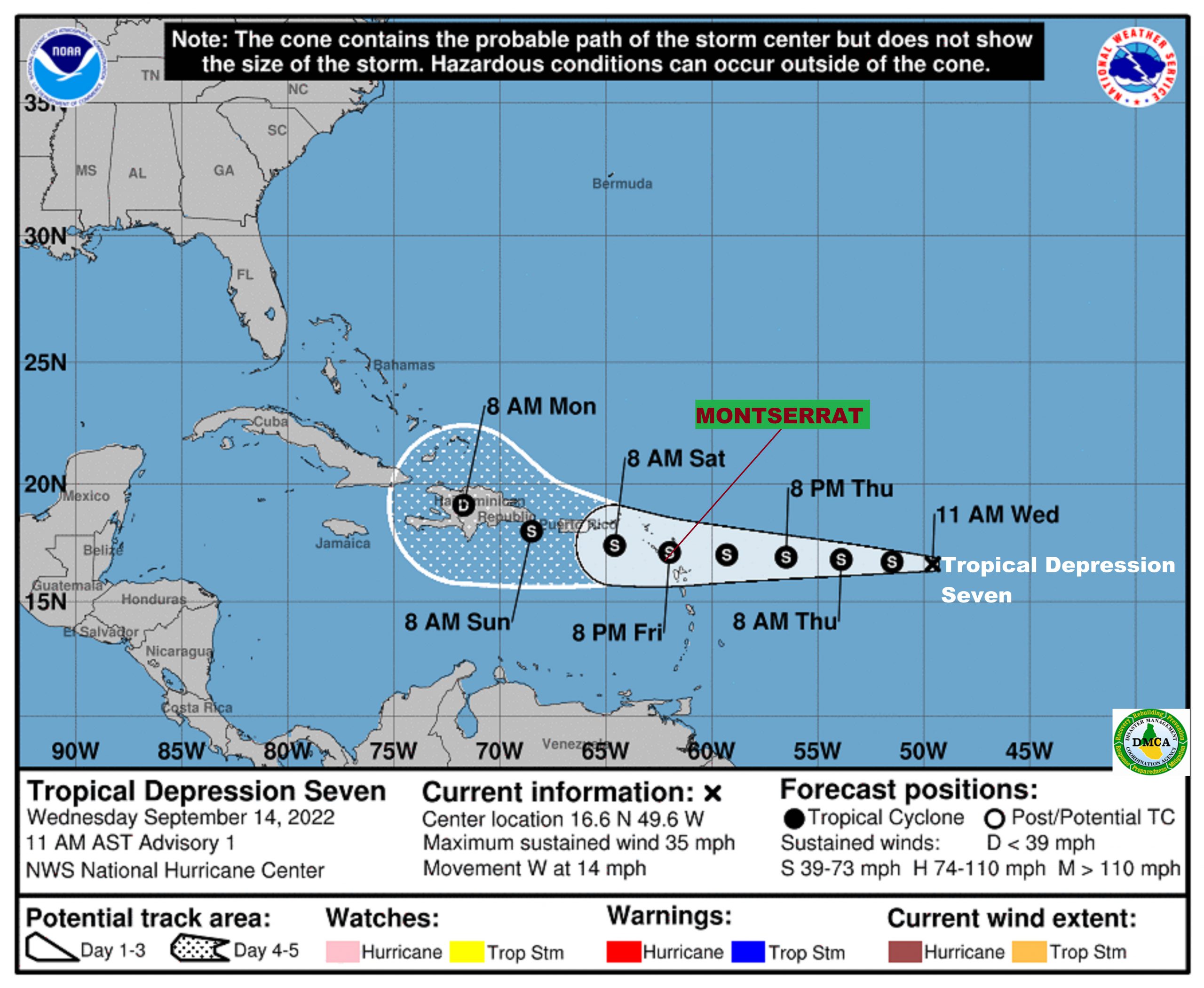
ACCORDING TO A TROPICAL CYCLONE ALERT STATEMENT ISSUED BY THE ANTIGUA AND BARBUDA METEOROLOGICAL SERVICES THIS EVENING, A TROPICAL CYCLONE ALERT MEANS THAT, IN THIS CASE, A TROPICAL DEPRESSION IS IN OUR MONITORED AREA OF CONCERN.
BASED ON THE LATEST INFORMATION AND ANALYSIS, THERE IS AN INCREASING THREAT OF TROPICAL CYCLONE IMPACTS AFFECTING THE LEEWARDS WHICH INCLUDE MONTSERRAT DURING THE WEEKEND; HOWEVER, THERE REMAINS SOME UNCERTAINTY OF THE MAGNITUDE OF THE IMPACTS AT THIS TIME; HENCE, RESIDENTS ARE ADVISED TO CONTINUE TO CLOSELY MONITOR THE PROGRESS OF THIS SYSTEM.
AT 500 PM, THE CENTER OF TROPICAL DEPRESSION SEVEN WAS LOCATED NEAR LATITUDE 16.8 NORTH, LONGITUDE 50.5 WEST OR 750 MILES EAST OF THE LEEWARDS AND 935 MILES EAST &8211; SOUTHEAST OF THE BVI.
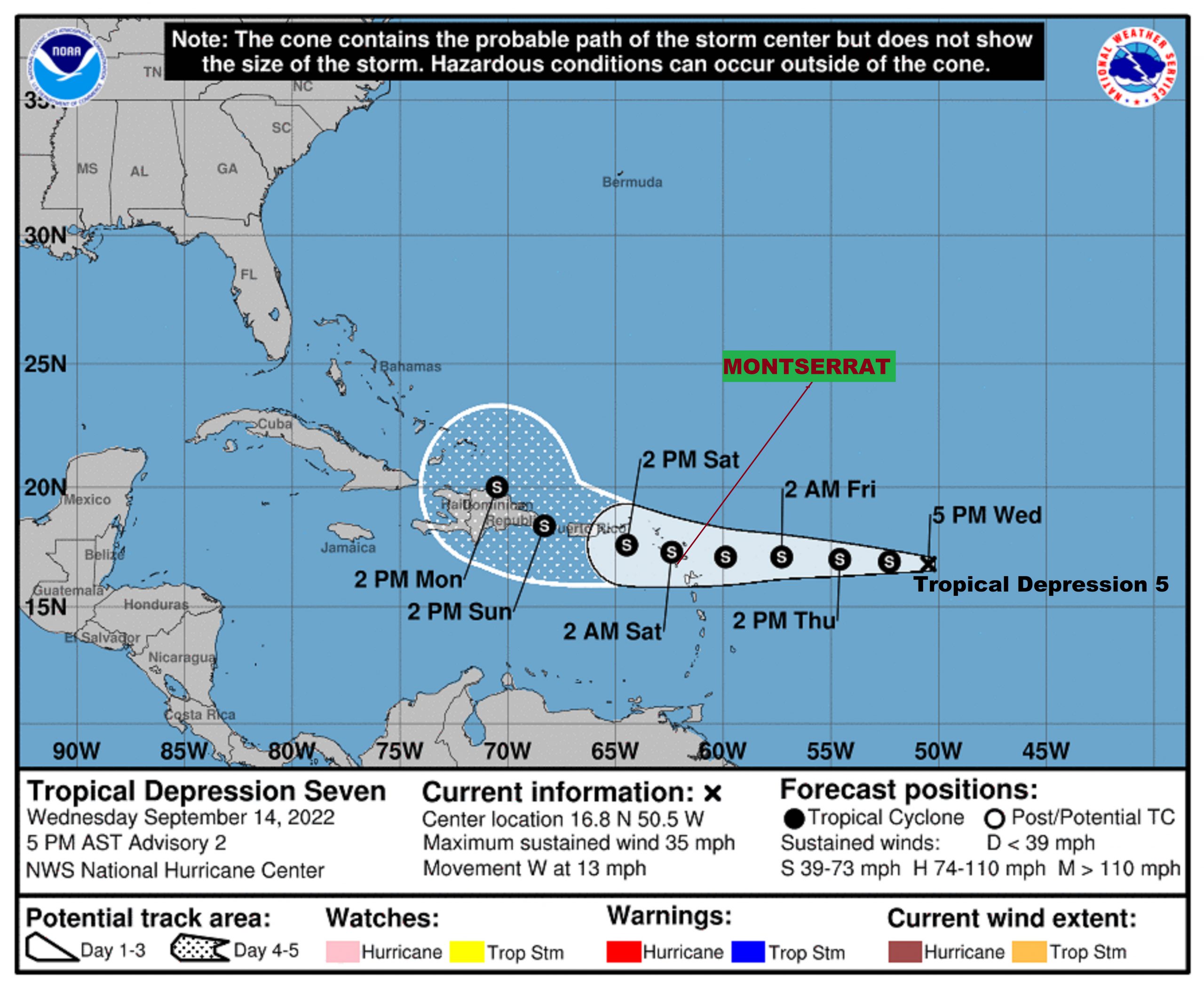
THE DEPRESSION IS MOVING TOWARD THE WEST NEAR 13 MPH (20 KM/H), AND THIS GENERAL MOTION IS EXPECTED TO CONTINUE DURING THE NEXT FEW DAYS.
MAXIMUM SUSTAINED WINDS ARE NEAR 35 MPH (55 KM/H) WITH HIGHER GUSTS. SOME GRADUAL STRENGTHENING IS FORECAST DURING THE NEXT DAY OR SO, AND THE DEPRESSION IS FORECAST TO BECOME A TROPICAL STORM TONIGHT OR THURSDAY.
THE ESTIMATED MINIMUM CENTRAL PRESSURE IS 1008 MB (29.77 INCHES).
ON ITS FORECAST TRACK, THE CYCLONE WILL LIKELY BE NEAR THE ISLANDS THIS WEEKEND, AS A MINIMAL TROPICAL STORM BRINGING POSSIBLE IMPACTS OF GUSTY WINDS, HEAVY RAINFALL AND ROUGH SEAS.
CURRENTLY, THERE ARE NO WATCHES OR WARNINGS IN EFFECT AT THIS TIME; BUT WILL LIKELY BE REQUIRED LATER TONIGHT OR EARLY TOMORROW; HENCE, RESIDENTS ARE ADVISED TO MONITOR THE PROGRESS OF THE SYSTEM.
THE NEXT ADVISORY WILL BE AT AROUND 11 PM OR SOONER IF NEEDED.
FORECASTER BERNELL SIMON/LENARD JOSIAH