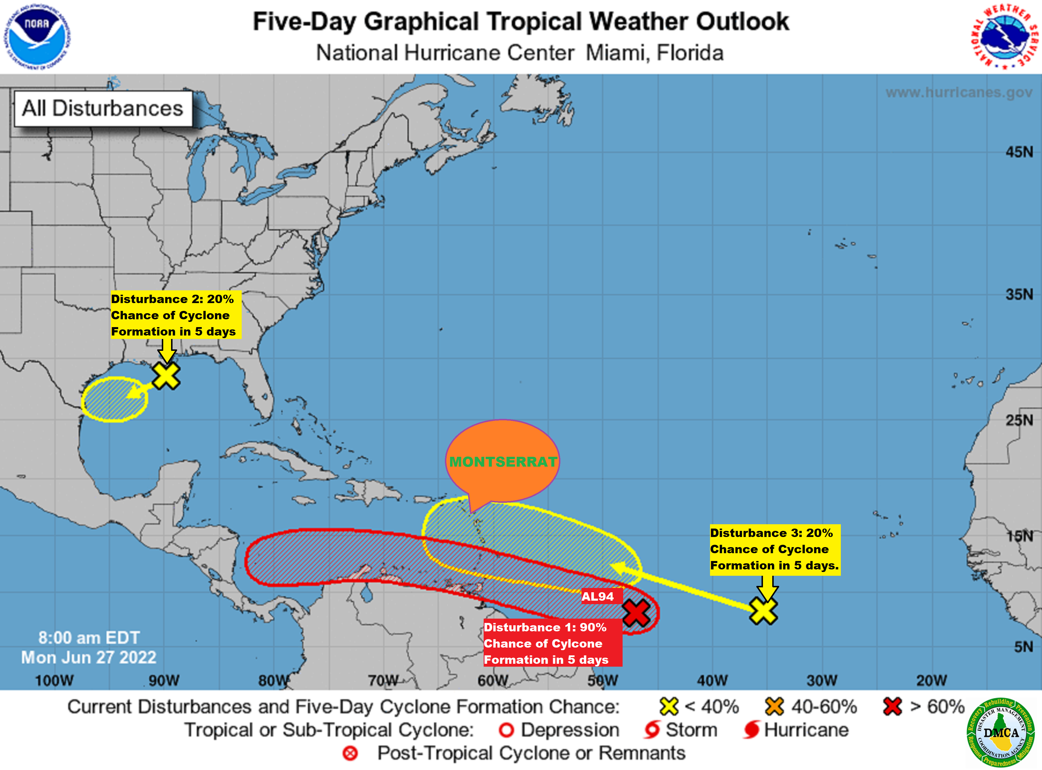
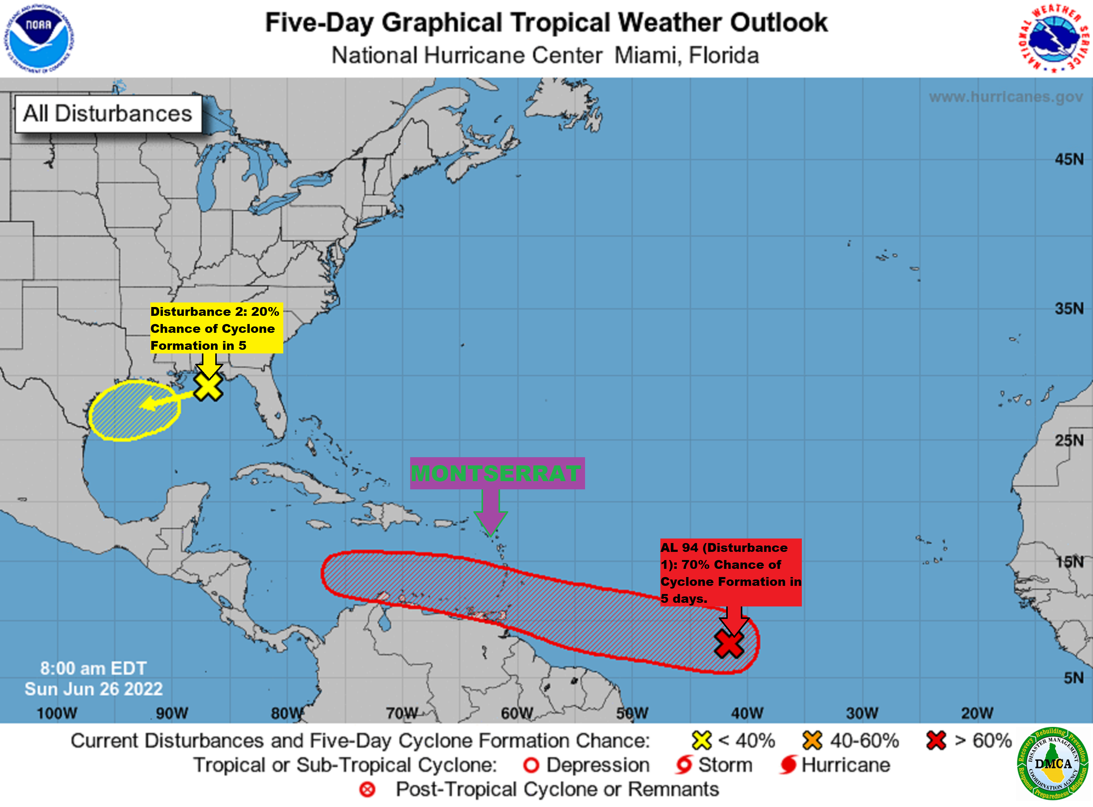
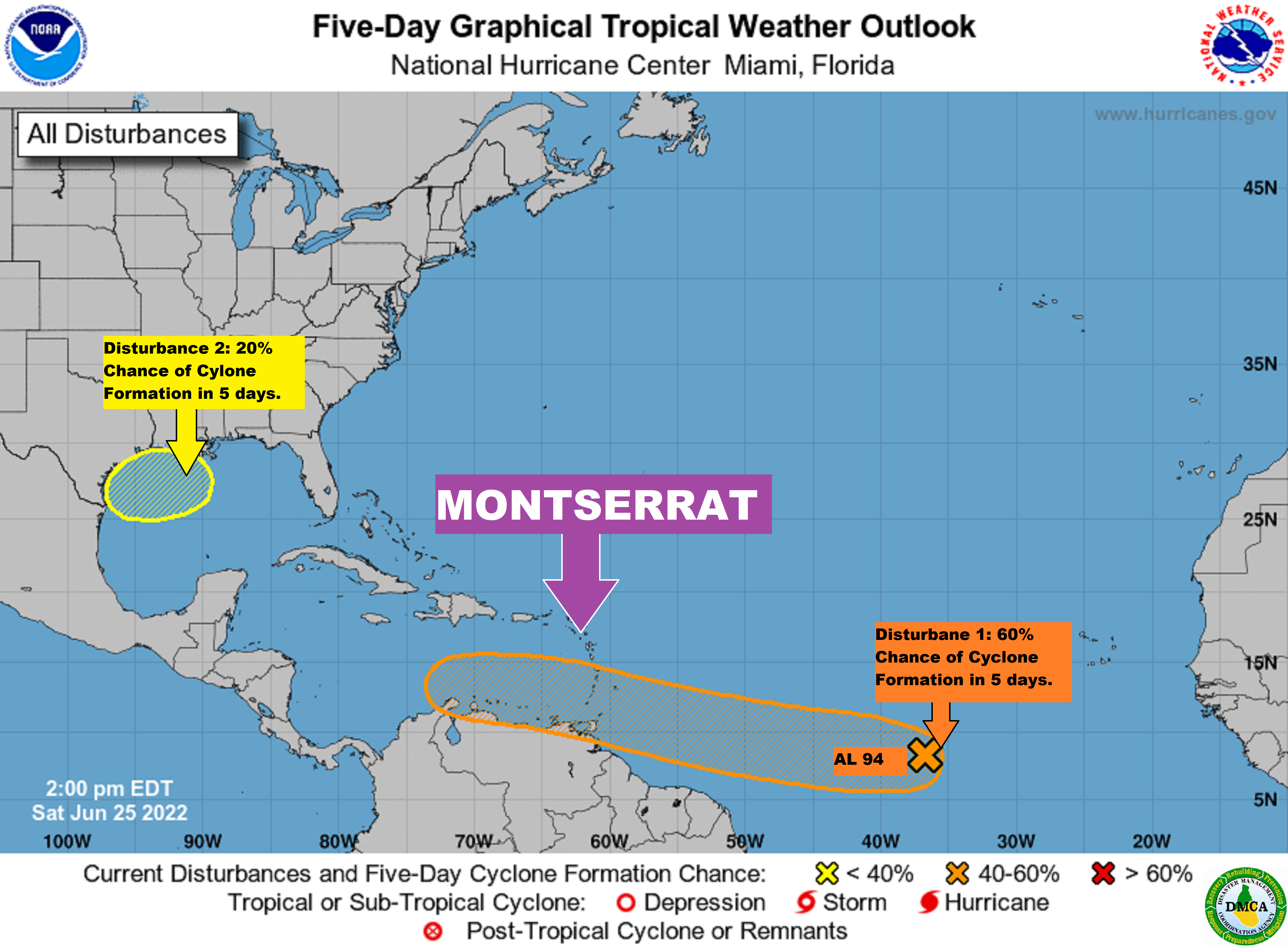
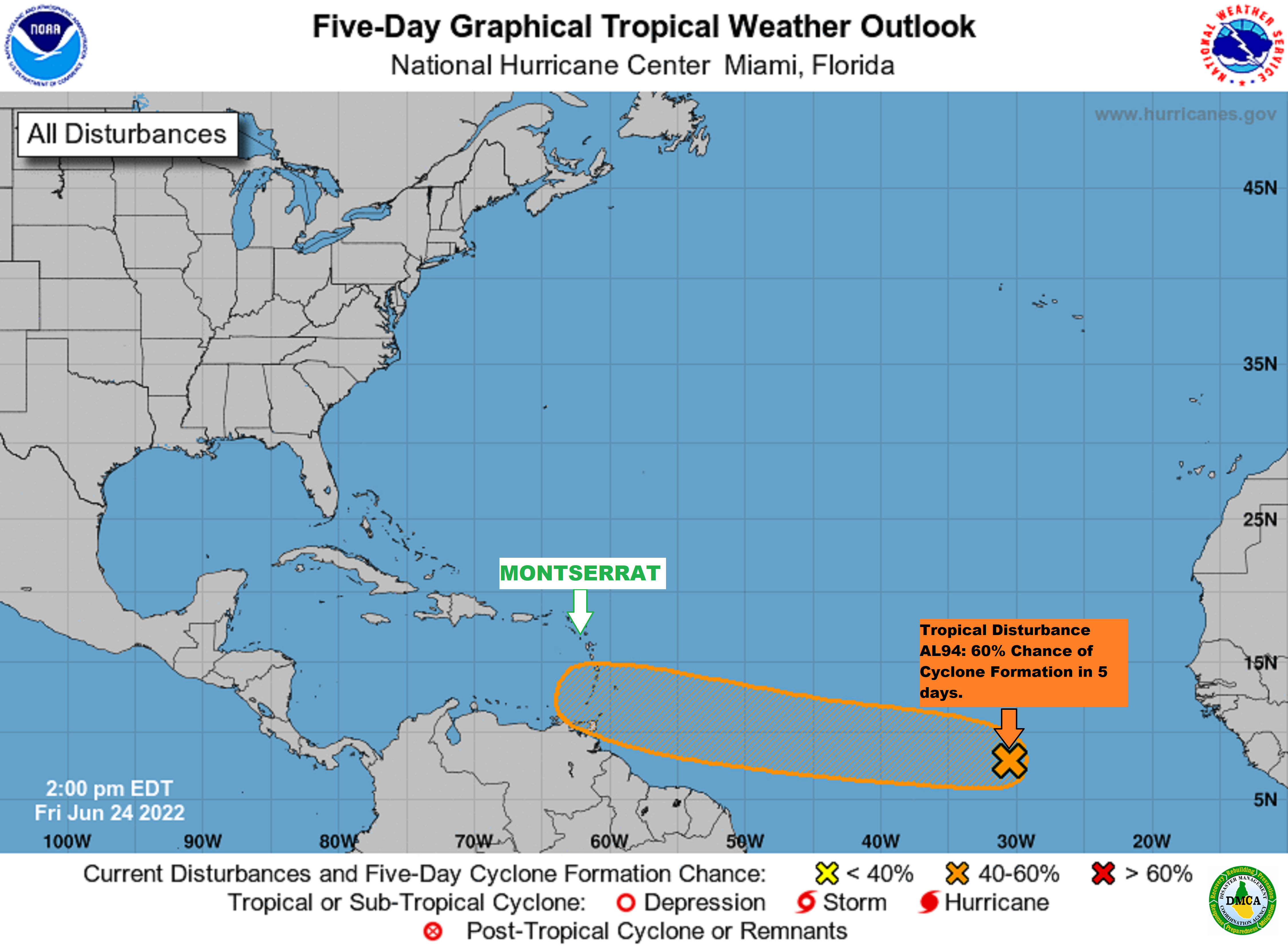
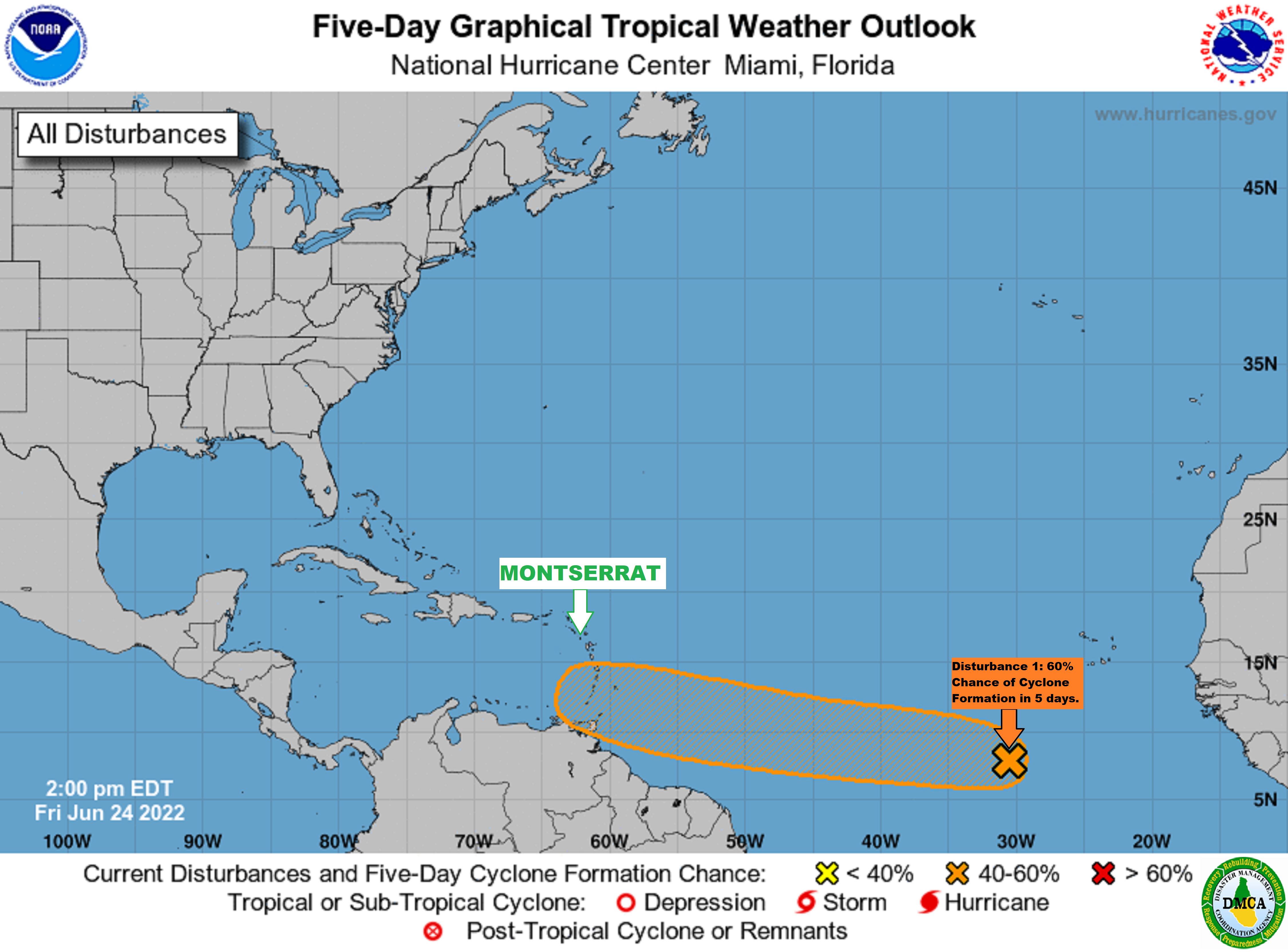
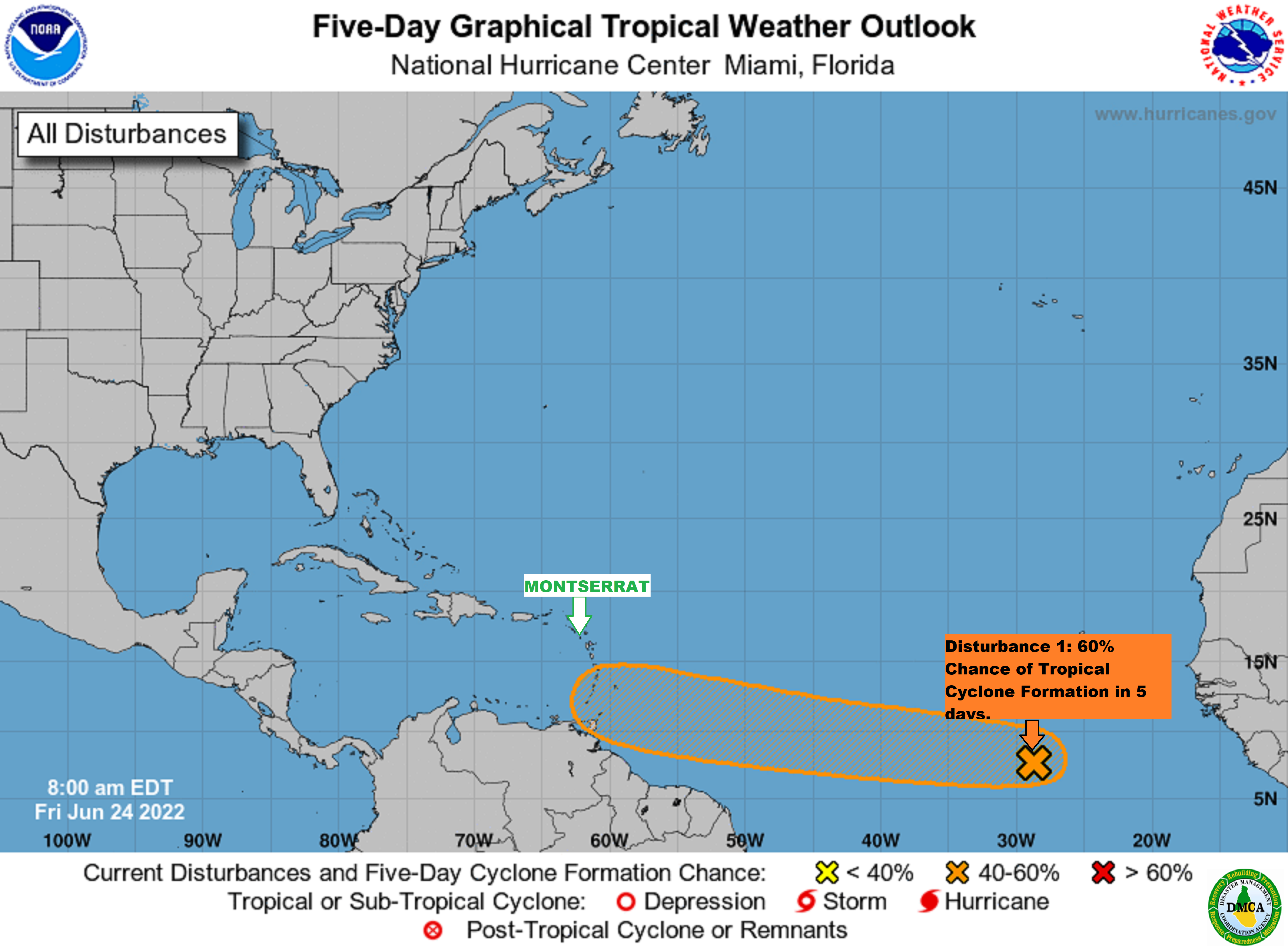
Small Craft Advisory in effect for Open Waters on the Atlantic Side of Montserrat out to 20 nautical miles, due to Above Normal Swell Heights!

According to a Small Craft Caution issued by the Antigua and Barbuda Meteorological Services on Sunday evening, inexperienced mariners, especially those operating smaller vessels should avoid navigating in these conditions.

The Disaster Management Coordination Agency, DMCA is also urging fisherfolks to be vigilant and boat owners are advised to check their moorings.

Locations to be affected: Mainly open waters on the Atlantic sides of the islands out to 20 nautical miles.

Timing: Until Friday
.
Synopsis: A combination of wind waves and wind swells is causing hazardous seas, especially for open waters on the Atlantic sides of the islands. The threat level to the life, livelihood, property
and infrastructure of mariners is high with the potential for extensive impacts.
A small craft advisory means that wind speeds of 21 to 33 knots and or wind waves and or wind swells of 7 feet or greater are occurring or imminent.

Winds over open waters: East at 26 to 41 km/h (14 to 22 knots; 16 to 25 mph), with strong gusts to around 63 km/h (34 knots; 39 mph).

Seas (significant wave heights): 1.8 to 3 metres (6 to 10 feet), occasionally or locally reaching near 3.8 metres (13 feet). Wind waves and or wind swells: 1.8 to 3 metres or 6 to 10 feet and occasionally higher. The worst conditions are likely Monday through Thursday, when seas and winds are expected to be highest. The dominant wind wave period is 6 to 9 seconds.

Potential Impacts: Loss of life at sea; injuries to mariners; capsize or damage or loss of vessels and marine equipment; financial losses; disruption of fisheries and scarcity of fish products and disruption to marine transportation.

Forecaster: Dale Destin

8 AM UPDATE: Two tropical Disturbances in the Gulf of Mexico and the Atlantic. None of the systems is a threat to Montserrat at this time; Tropical Disturbance AL94 poses little to no wind threat to Montserrat!

According to the latest Tropical Cyclone Information Statement issued by Antigua and Barbuda Meteorological Services on Saturday evening, Tropical Disturbance AL94 is likely to be in the vicinity of the windward islands Tuesday/Wednesday, at which time, it is forecast to be a storm with the potential to be a hurricane.

It states that at this time, even at the reasonable worst-case, the likely Tropical Cyclone poses little to no wind threat to Montserrat. No immediate preparations are needed; however, you should be prepared for the hurricane season.

Maximum sustained winds were near 25 mph with higher gusts. There is a 40 percent chance of formation into a tropical cyclone in 48 hours and a 70 percent chance of formation in 5 days.
The disturbance could become a Tropical Depression during the first half of next week.

On its forecast track, the probable tropical cyclone is forecast to arrive in the Windward islands around the middle of next week as a tropical storm with the potential to be a hurricane. There is still a lot of uncertainty and a lot of time for unexpected changes to take place, including the system tracking more towards the northeast Caribbean and raising the threat level.

Please note that no tropical cyclone alerts, watches or warnings are in effect, at this time, and none is anticipated based on the forecast track of the system.

Residents should monitor this developing system and be prepared for the Hurricane season.

Meantime, Tropical Disturbance 2 located in the Gulf of Mexico off the Texas-Louisiana coast poses no threat to Montserrat.

Continue to monitor DMCA Facebook, Instagram and Twitter social media sites and our website http://dmca.gov.ms for daily weather updates, public advisories and warnings and information on the wide range of natural and man-made hazards that have the potential to impact Montserrat.

2 PM UPDATE: Two Tropical Depressions Could Form Next Week in the Gulf of Mexico and the Atlantic Ocean – None of the Disturbances pose a threat to Montserrat at this time.

According to the latest Tropical Cyclone Information Statement issued by the Antigua and Barbuda Meteorological Services, Tropical disturbance AL 94 is likely to be in the vicinity of the Windward islands Tuesday/Wednesday, at which time, it is forecast to be a storm with the potential to be a hurricane.

The statement went on to say, at this time, even at the reasonable worst-case, Tropical Disturbance AL94 poses little to no threat to Montserrat. Hence, no immediate preparations are needed; however, residents should be prepared for the hurricane season.

Maximum sustained winds were near 25 mph with higher gusts. There is a 30 percent chance of formation into a tropical cyclone in 48 hours and a 60 percent chance of formation in 5 days.

It states that the Disturbance could become a Tropical Depression during the first half of next week. On its forecast track, the probable tropical cyclone is forecast to arrive in the Windward Islands around the middle of next week as a tropical storm with the potential to be a hurricane. There is still a lot of uncertainty and a lot of time for unexpected changes to take place, including the system tracking more towards the northeast Caribbean and raising the threat level.

Please note that no tropical cyclone alerts, watches or warnings are in effect, at this time, and none is anticipated based on the forecast track of the system.

Residents should monitor this developing system and be prepared for the hurricane season.

Meantime, Tropical Disturbance 2 located in the Gulf of Mexico off the Texas-Louisiana coast poses no threat to Montserrat.

Continue to monitor DMCA Facebook, Instagram and Twitter social media sites and our website http://dmca.gov.ms for daily weather updates, public advisories and warnings and information on the wide range of natural and man-made hazards that have the potential to impact Montserrat.

Air Quality drops to moderate levels today Saturday across Montserrat, due to the presence of Saharan Dust in the Atmosphere – Residents who are Sensitize to this change in Air Quality should take the Necessary Precautions!

That’s according to an Air Quality Alert issued by the Antigua and Barbuda Meteorological Services on Friday night.

It states that the threat of health problems is forecast to be
elevated, for mainly unusually sensitive people, such as asthmatics, and could potentially cause them limited health impacts.

Air Quality Index Based on Particulate Matters 2.5 (PM2.5) and 10 (PM10) Concentration

Air quality category: Moderate

Timing: Saturday morning to Wednesday

Air quality index: 51 to 80

Alert Level: II

Sensitive groups: People with respiratory or heart disease, the elderly and children are the groups most at risk.

Health implications: Air quality is acceptable; however, for some pollutants, there may be moderate health concerns for a very small number of people who are unusually sensitive to air pollution.

Continue to monitor DMCA Facebook, Instagram and Twitter social media sites and our website http://dmca.gov.ms for daily weather updates, public advisories and warnings and information on the wide range of natural and man-made hazards that have the potential to impact Montserrat.

Tropical Disturbance AL94 Poses Little to no threat to Montserrat – Residents should monitor this developing system and be Prepared for the Hurricane Season.

That’s according to a Tropical Cyclone Information Statement issued by Antigua And Barbuda Meteorological Services at 3:45 PM on Friday, June 24 2022.

It states that Tropical Disturbance AL94 is likely to be in the vicinity of the Windward Islands Tuesday/Wednesday, at which time it is forecast to be a storm with the potential to be a hurricane. At this time, even at the reasonable worst-case, the Tropical cyclone poses little to no threat to Montserrat. No immediate preparations are needed; however, you should be prepared for the hurricane season.

At 2 PM, Tropical Disturbance AL94 was located about 2160 miles East-southeast of the Leeward Islands moving west at 15 to 20 mph.

Maximum sustained winds are near 25 mph with higher gusts. There is a 20 percent chance of formation into a tropical cyclone in 48 hours and a 60 percent chance of formation in 5 days. It could become a tropical depression during the early part of next week.

On its forecast track, the probable tropical cyclone is forecast to arrive in the Windward Islands around the middle of next week. At which time it could be a tropical storm or hurricane. There is still a lot of uncertainty and a lot of time for unexpected changes to take place, including the system tracking more towards the Northeast Caribbean and raising the threat level.

Please note that no tropical cyclone alerts, watches or warnings are in effect at this time and none is anticipated based on the forecast track of the system.

An Update Will Be Given Around 9 Am Tomorrow Saturday Or Sooner If Required.

Forecaster Dale Destin

Continue to monitor DMCA Facebook, Instagram and Twitter social media sites and our website http://dmca.gov.ms for daily weather updates, public advisories and warnings and information on the wide range of natural and man-made hazards that have the potential to impact Montserrat.

2 PM UPDATE: DMCA Continues to closely monitor a Tropical Disturbance in the Atlantic that could become a Tropical Depression by Mid-Next Week!

Yellow Hill, June 24, 2022 – The Disaster Management Coordination Agency, DMCA is closely monitoring a Tropical Wave located over the eastern tropical Atlantic that continues to produce a large area of disorganized showers and thunderstorms.

In its 2 pm advisory, the National Hurricane Center, NHC states that conditions appear conducive for the development of this system over the next few days and, a tropical depression could form during the early to the middle part of next week while it moves westward at 15 to 20 mph over the tropical Atlantic and approaches the Windward Islands.

The system has a 20% chance of formation in the next two days and 60% in the next five days.

The DMCA is encouraging residents to review their hurricane plans and complete their hurricane preparations now.

The Disaster Management Coordination Agency, DMCA will continue to monitor the Tropical Atlantic for any development with tropical disturbance 1 and provide regular updates as information is released from the NHC.

DMCA Closely Monitors a Tropical Disturbance in the Atlantic that could become a Tropical Depression next week!

Yellow Hill, June 24, 2022 – The Disaster Management Coordination Agency, DMCA is monitoring a Tropical Wave located over the eastern tropical Atlantic that continues to produce a large area of disorganized showers and thunderstorms.

The National Hurricane Center, NHC states that a tropical depression could form during the early to the middle part of next week while it moves westward at around 15 mph over the tropical Atlantic and approaches the Windward Islands.

The system has a 20% chance of formation in the next two days and 60% in the next five days.

The DMCA is encouraging residents to review their hurricane plans and complete their hurricane preparations now.

The Disaster Management Coordination Agency, DMCA will continue to monitor the Tropical Atlantic for any development with tropical disturbance 1 and provide regular updates as information is released from the NHC.

2 PM UPDATE: DMCA Monitors Tropical Disturbance that Forecasters say may be of concern to the Eastern Caribbean which includes Montserrat!

Yellow Hill, June 23, 2022 – The Disaster Management Coordination Agency, DMCA is monitoring a Tropical Wave located over the eastern tropical Atlantic producing disorganized showers and thunderstorms.

The National Hurricane Center, NHC states that gradual development of this system is expected by early next week as the disturbance moves westward at around 15 mph over the tropical Atlantic.

The system has a 0% chance of formation in the next two days and 20% in the next five days.

The DMCA is encouraging residents to review their hurricane plans and complete their hurricane preparations now.

The Disaster Management Coordination Agency, DMCA will continue to monitor the Tropical Atlantic for any development with tropical disturbance 1 and provide regular updates as information is released from the NHC.

DMCA Monitors Tropical Disturbance that Forecasters say may be of concern to the Eastern Caribbean which includes Montserrat!

Yellow Hill, June 23, 2022 – The Disaster Management Coordination Agency, DMCA is monitoring a Tropical Wave located over the eastern tropical Atlantic producing disorganized showers and thunderstorms.

The National Hurricane Center, NHC states that gradual development of this system is expected by early next week as the disturbance moves westward at around 15 mph over the tropical Atlantic.

The system has a 0% chance of formation in the next two days and 20% in the next five days.

The Disaster Management Coordination Agency, DMCA will continue to monitor the Tropical Atlantic for any development with tropical disturbance 1 and provide regular updates as information is released from the NHC.

Montserrat’s state of readiness for the 2022 Atlantic Hurricane Season was the focus of a half-day conference today.

The Disaster Management Coordination Agency (DMCA) held its annual Hurricane Conference and Expo on Friday, June 17, 2022, under the theme “Be prepared, stay prepared, it only takes one”.

The aim of the conference was to improve hurricane preparedness, response, recovery and mitigation on Montserrat to save lives, reduce damage to homes, communities, and infrastructure and recover more quickly if a tropical storm or hurricane should impact the island.

The event brought together a broad cross-section of stakeholders from both the private and public sectors to provide an update on their organization’s level of readiness for the Hurricane Season.

The event also serves as a national forum to exchange ideas and generate solutions for any possible hurricane-related challenges Montserrat may face to improve the island’s resilience to storms or hurricanes.

Several presentations were made at the conference including the Disaster Management Coordination Agency Hurricane readiness and the Outlook and Forecast for the 2022 Atlantic Hurricane Season and various stakeholders provided updates on Montserrat’s infrastructure, food and fuel stock.

The expo showcased communication equipment, first aid and emergency survival kits used in emergency situations.