SHOWERS AND THUNDERSTORMS WILL CONTINUE ACROSS THE ISLAND TONIGHT AND TOMORROW.
THE ANTIGUA METEOROLOGICAL SERVICES (MET OFFICE) DISCONTINUED THE TROPICAL STORM WARNING FOR MONTSERRAT, AS POTENTIAL TROPICAL CYCLONE NINE CONTINUES TO MOVES WESTWARD AND NO LONGER POSED A THREAT TO THE ISLAND.
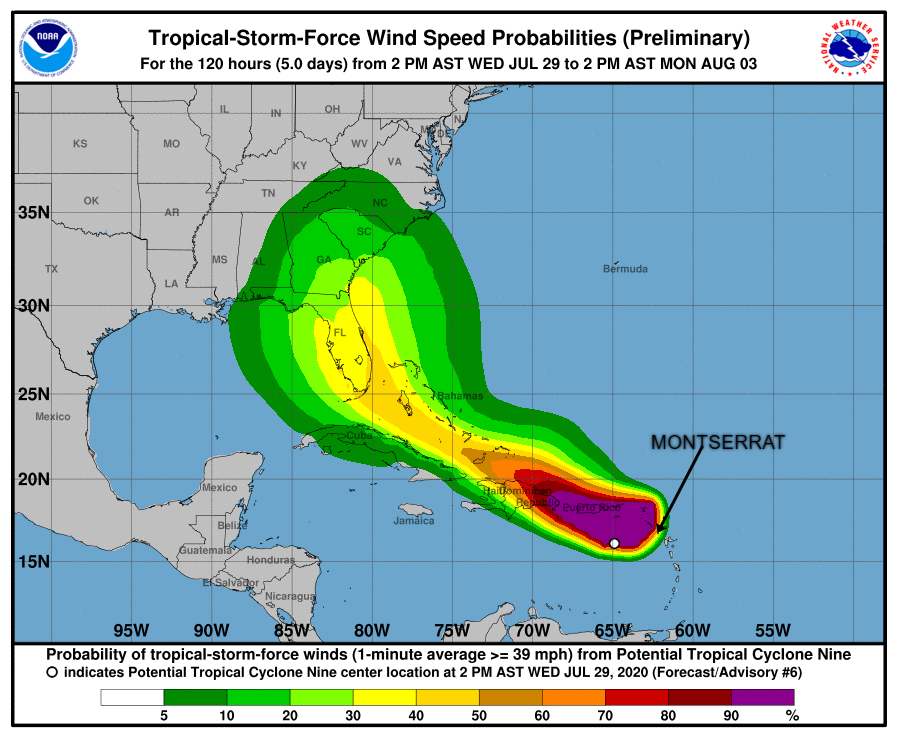
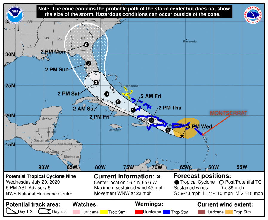
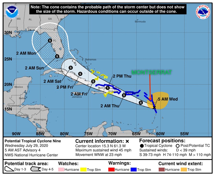
Yellow Hill, Montserrat – July 29, 2020 – At 500 PM, the disturbance was centered near latitude16.4 North, longitude 65.6 West. The system is moving toward the west-northwest near 23 mph (37 km/h), and this general motion with a reduction in forward speed is expected over the next few days. On the forecast track, the system will pass south of Puerto Rico later tonight, near or over Hispaniola on Thursday, near eastern Cuba and the southeastern Bahamas on Friday, and approach the northwestern Bahamas and southern Florida Friday night.
Maximum sustained winds are near 45 mph (75 km/h) with higher gusts. Some increase in strength is forecast through tonight, with weakening likely on Thursday due to land interaction. Somerestrengthening is possible by this weekend.
Environmental conditions are expected to be conducive for additional development and a tropical storm is forecast to form tonight.
* Formation chance through 48 hours…high…90 percent.
* Formation chance through 5 days…high…90 percent.
Tropical-storm-force winds extend outward up to 275 miles (445 km) primarily to the north of the center. A wind gust of 52 mph (83 km/h) was recently reported at St. Thomas in the U.S. Virgin Islands.
The estimated minimum central pressure is 1004 mb (29.65 inches).
THE DMCA IS ALSO URGING RESIDENTS TO CONTINUE TO FOLLOW THEIR HURRICANE FAMILY PLAN AND REMAIN VIGILANT.
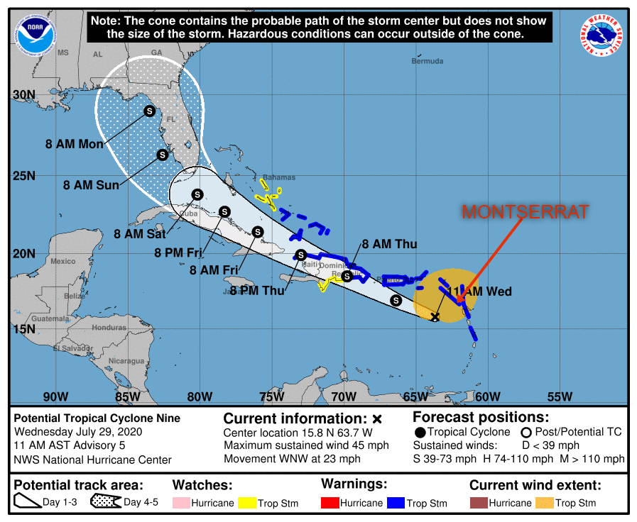
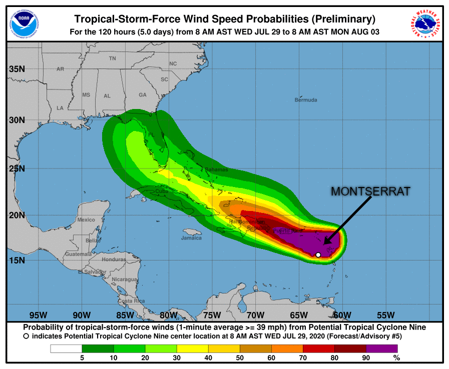
Yellow Hill, Montserrat – July 29, 2020 – At 1100 AM, the disturbance was centered near latitude 15.8 North, longitude 63.7 West. The system is moving toward the west-northwest near 23 mph (37 km/h), and this general motion with a reduction in forward speed is expected over the next few days. On the forecast track, the system will move near or just south of Puerto Rico later today and tonight, near or over Hispaniola on Thursday, and near or over eastern Cuba on Friday.
Maximum sustained winds are near 45 mph (75 km/h) with higher gusts. Some increase in strength is forecast through tonight, with weakening likely on Thursday due to land interaction. Some restrengthening is possible this weekend.
Environmental conditions are expected to be conducive for additional development, and a tropical storm is forecast to form later today or tonight.
* Formation chance through 48 hours…high…90 percent
* Formation chance through 5 days…high…90 percent
Tropical-storm-force winds extend outward up to 275 miles (445 km) primarily to the north and northeast of the center.
The estimated minimum central pressure is 1006 mb (29.71 inches).
CONDITIONS ARE EXPECTED TO DETERIORATE THIS AFTERNOON AS THE SYSTEM PASS ITS CLOSEST TO MONTSERRAT AT 3 O’CLOCK.
RESIDENTS ARE URGED TO ERR ON THE SIDE OF CAUTION AND STAY VIGILANT AS ENVIRONMENTAL CONDITIONS ARE EXPECTED TO BE CONDUCIVE FOR ADDITIONAL DEVELOPMENT, AND A TROPICAL STORM IS FORECAST TO FORM LATER TODAY.
Yellow Hill, Montserrat – July 29, 2020 -At 800 AM, the disturbance was centered near latitude 15.1 North, longitude 62.1 West. The system is moving toward the west-northwest near 23 mph (37 km/h), and this general motion with some reduction in forward speed is expected over the next few days. On the forecast track, the system will move near or over Puerto Rico tonight, near or over Hispaniola on Thursday, and near or over the southeastern Bahamas on Friday.
Maximum sustained winds remain near 45 mph (75 km/h) with higher gusts. Some increase in strength is forecast today, with weakening likely on Thursday due to land interaction, and some restrengthening possible late week. Environmental conditions are expected to be conducive for additional development, and a tropical storm is forecast to form later today.
Formation chance through 48 hours…high…90 percent*
Formation chance through 5 days…high…90 percent
Tropical-storm-force winds extend outward up to 275 miles (445 km) primarily to the north and northeast of the center.
A wind gust of 46 mph (74 km/h) was recently reported on St. Kitts. Potential impacts
• Rainfall between 3 – 6 inches with maximum amounts of 10 inches in some locations.
• Winds may increase to 50 – 60 mph.
Power outages are possible.
• Storm surge is possible for shoreline areas
• A Small Craft Warning has been issued until Thursday
Yellow Hill, Montserrat – July 28, 2020 – At 1100 PM, the disturbance was centered near latitude 14.6 North, longitude 59.4 West. The system is moving toward the west-northwest near 25 mph (41 km/h), and this general motion with some slight reduction in forward speed is expected over the next few days. On the forecast track, the system will move through the Leeward Islands on Wednesday, near or over the Virgin Islands and Puerto Rico Wednesday night, and near or over Hispaniola on Thursday. Maximum sustained winds are near 40 mph (65 km/h) with higher gusts. Some strengthening is expected during the next 48 hours, and the system is forecast to become a tropical storm on Wednesday. Environmental conditions are expected to be conducive for additional development, and a tropical storm is forecast to form on Wednesday.
* Formation chance through 48 hours…high…90 percent* Formation chance through 5 days…high…90 percent
Tropical-storm-force winds extend outward up to 230 miles (370 km) from the center.
The estimated minimum central pressure is 1007 mb (29.74 inches).
THE ANTIGUA MET OFFICE HAS ADVISED THAT BASED ON THE POTENTIAL IMPACT OF TROPICAL CYCLONE NINE ON THE ISLAND IT HAS ISSUED A TROPICAL STORM WARNING FOR MONTSERRAT.
A TROPICAL STORM WARNING MEANS THAT TROPICAL STORM CONDITIONS ARE EXPECTED SOMEWHERE WITHIN THE WARNING AREA WITHIN 36 HOURS.
THE DMCA WILL BE PROVIDING AN UPDATE ON ZJB RADIO MONTSERRAT ABOUT 5:00 O’CLOCK THIS AFTERNOON.
Yellow Hill, Montserrat – July 28, 2020 – At 1100 AM, the disturbance was centered near latitude 13.8 North, longitude 53.7 West. The system is moving toward the west near 23 mph (37 km/h), and this general motion should continue during the next few days. On the forecast track, the system is forecast to move through the Leeward Islands on Wednesday, and near or over the Virgin Islands and Puerto Rico Wednesday night, and near or over Hispaniola on Thursday. Maximum sustained winds are near 40 mph (65 km/h) with higher gusts.Some strengthening is expected during the next 48 hours, and the system is forecast to become a tropical storm tonight or Wednesday.
Environmental conditions are expected to be conducive for additional development and a tropical storm tonight or Wednesday.* Formation chance through 48 hours…high…80 percent* Formation chance through 5 days…high…90 percent
Tropical-storm-force winds extend outward up to 230 miles (370 km) primarily to the northeast of the center.
The estimated minimum central pressure is 1007 mb (29.74 inches)
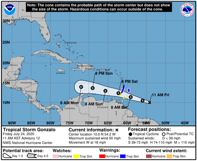
Yellow Hill, Montserrat – July 24, 2020 – A tropical wave located about 300 miles southeast of the Cabo Verde Islands is producing an area of cloudiness and disorganized thunderstorms. The disturbance is expected to move westward across the tropical Atlantic during the next several days, and some gradual development of this system is possible by early next week when it reaches the western tropical Atlantic.
* Formation chance through 48 hours…low…near 0 percent. * Formation chance through 5 days…low…30 percent. Forecaster Stewart
Yellow Hill, Montserrat – July 24, 2020 – At 1100 AM, the center of Tropical Storm Gonzalo was located near latitude 10.0 North, longitude 54.2 West. Gonzalo is moving toward the west near 18 mph (30 km/h). A general westward- to west-northwestward motion is expected during the next couple of days. On the forecast track, the center of Gonzalo will approach the southern Windward Islands tonight and then move across the islands on Saturday and over the eastern Caribbean Sea on Sunday.
Maximum sustained winds are near 50 mph (85 km/h) with higher gusts. There is considerable uncertainty in the intensity forecast, but some strengthening is still possible during the next day or so before Gonzalo reaches the southern Windward Islands. Weakening is expected after Gonzalo moves into the Caribbean Sea, and the cyclone is expected to dissipate by the middle of next week.
Gonzalo is a small tropical cyclone. Tropical-storm-force winds extend outward up to 25 miles (35 km) from the center. The estimated minimum central pressure is 1002 mb (29.59 inches).