Yellow Hill Road, Montserrat – Sunday, 3 September 2023: The Disaster Management Coordination Agency (DMCA) is closely monitoring the progress of Tropical Disturbance AL95 located over the central Tropical Atlantic moving generally westward and could become a Tropical Depression this week. The seven-day forecast cone, or “cone of uncertainty” includes Montserrat. The system’s odds of development in 7 days have increased to 80%.
Tropical Disturbance AL 95 is located several hundred miles southwest of the Cabo Verde Islands. This system has become better organized since yesterday, and environmental conditions appear conducive for further development this week. A tropical depression is likely to form around midweek while the system moves westward to west-northwestward at 15 to 20 mph over the central and western portions of the tropical Atlantic.
Formation chance through 48 hours: low, near 40 percent.
Formation chance through seven days: low, 80 percent.
Residents are encouraged to have their hurricane kits ready with enough supplies to last for at least three days, pay close attention to information, issued by the DMCA and be prepared.
DMCA will continue to monitor Tropical Disturbance 1 and provide regular updates until the system passes Montserrat.
Yellow Hill Road, Montserrat – Saturday, 2 September 2023: The Disaster Management Coordination Agency (DMCA) is closely monitoring the progress of Tropical Disturbance 1 located over the far eastern tropical Atlantic moving generally westward with a high chance of development in 7 days. The seven-day forecast cone, or “cone of uncertainty” includes Montserrat, hence, Residents are encouraged to have their hurricane kits ready with enough supplies to last for at least three days, pay close attention to information, issued by the DMCA and be prepared.
Tropical Disturbance 1 is located over the far eastern tropical Atlantic. Environmental conditions appear conducive for some gradual development of this system by the middle part of next week, and a tropical depression is likely to form while it moves westward to west-northwestward at 15 to 20 mph over the eastern and central portions of the tropical Atlantic.
Formation chance through 48 hours: low, near 20 percent. Formation chance through seven days: low, 70 percent.
The DMCA will continue to monitor Tropical Disturbance 1 and provide regular updates until the system passes Montserrat.
Yellow Hill Road, Montserrat – Saturday, 19 August 2023: The Disaster Management Coordination Agency (DMCA) continues to closely monitor the progress of Tropical Disturbance 3 ( AL90) near the Windward Islands now with a 60% chance of development in 7 days. The seven-day forecast cone, or “cone of uncertainty” includes Montserrat, hence, Residents are encouraged to have their hurricane kits ready with enough supplies to last for at least three days, pay close attention to information, issued by the DMCA and be prepared.
Tropical Disturbance 3 formed near the Windward Islands, shower and thunderstorm activity has become better organized since yesterday. Some additional development of this system is likely and a tropical depression could form by early next week while this system moves westward to west-northwestward at 10 to 15 mph, across the Lesser Antilles and over the eastern and central Caribbean Sea. Regardless of development, heavy rainfall is possible over portions of the Windward Islands during the next couple of days. Interests in the eastern and central Caribbean should monitor the progress of this system.
Formation chance through 48 hours: low, near 40 percent. Formation chance through seven days: low, 60 percent.
According to Meteorologist, Dale Destin, Tropical Disturbance AL90, which has a 60% chance of formation in 7 days could become a Tropical Storm early next week and become a BIG problem for the central or western Caribbean.
Meanwhile, Tropical Depression 6 and Tropical Disturbances 1 (red) and 5 (yellow) are not an immediate threat to Montserrat at this time, however, DMCA continues to monitor these two systems.
The DMCA will continue to monitor Tropical Disturbance 3 and provides regular updates until the system passes Montserrat.
Yellow Hill Road, Montserrat – Saturday, 19 August 2023: The Disaster Management Coordination Agency (DMCA) is closely monitoring the progress of Tropical Disturbance 3 ( AL90) East-Southeast of the Lesser Antilles now with a medium chance of development in 7 days. The seven-day forecast cone, or “cone of uncertainty” includes Montserrat, hence, Residents are encouraged to have their hurricane kits ready with enough supplies to last for at least three days, pay close attention to information, issued by the DMCA and be prepared.
According to Meteorologist, Dale Destin, notwithstanding the disturbance, we are still looking relatively safe from storm winds! Rain is in the forecast and flash flooding is possible across parts of the southern islands.
Tropical Disturbance 3 is located just east of the Windward Islands. Some gradual development of this system is possible and a tropical depression could form during the early and middle parts of next week while it moves westward to west-northwestward at 10 to 15 mph, across the Lesser Antilles and over the eastern and central Caribbean Sea.
Formation chance through 48 hours: low, near 20 percent. Formation chance through seven days: low, 40 percent.
Meanwhile, Tropical Disturbances 1 (red) and 2 (yellow) are not an immediate threat to Montserrat at this time, however, DMCA continues to monitor these two systems.
The DMCA will continue to monitor Tropical Disturbance 3 and provides regular updates until the system passes Montserrat.
Yellow Hill, Wednesday, 16 August 2023 – DMCA monitors two tropical disturbances in the Tropical Atlantic both with medium chances of development over the next 7 days. The systems pose no threat to Montserrat at this time.
Disturbance 1 located over the central tropical Atlantic is centered about 750 miles west-southwest of the Cabo Verde Islands. Gradual development of this system is expected, and a tropical depression could form during the next several days while moving toward the west or west-northwest at about 10 mph across the central tropical Atlantic.
Formation chance through 48 hours: low, near 30 percent. Formation chance through seven days: low, 50 percent.
Disturbance 2 moving off the west coast of Africa is forecast to move toward the west-northwest at about 15 mph, with an area of low pressure expected to form in a day or so near or just to the west of the Cabo Verde Islands. Further development of the low is possible, and a tropical depression could form over the weekend before environmental conditions become unfavourable early next week.
Formation chance through 48 hours: low, near 20 percent. Formation chance through seven days: low, 40 percent.
Residents are encouraged to have their hurricane kits ready with enough supplies to last at least three days, pay close attention to information, issued by the DMCA and be vigilant.
The DMCA will continue to monitor the systems and provides regular updates as deemed necessary.
Yellow Hill, Monday, 14 August 2023 – DMCA monitors two tropical disturbances in the Tropical Atlantic with a 30% and 20% Chance of development in 7 days. The systems pose no threat to Montserrat at this time.
Disturbance 1 is forecast to move off the west coast of Africa on Wednesday or early Thursday. Some slow development of this system will be possible late this week while the system moves gradually west-northwestward or northwestward across the eastern Atlantic.
Formation chance through 48 hours: low, near 0 percent. Formation chance through seven days: low, 30 percent.
Disturbance 2 could develop by the middle to the latter portion of this week over the central tropical Atlantic. Some slow development of this system is also possible while it moves west-northwestward through the end of the week.
Formation chance through 48 hours: low, near 0 percent. Formation chance through seven days: low, 20 percent.
Residents are encouraged to have their hurricane kits ready with enough supplies to last at least three days, pay close attention to information, issued by the DMCA and be vigilant.
The DMCA will continue to monitor the systems and provides regular updates as deemed necessary.
Shirlian Queeley completed the 15-week course which equipped officers with the “soft” skills of leadership, strategic programme management and relationship management, through which they can build high-performing teams and increase operational efficiency.
The intense training course covered the following modules, through a blend of theory and practical application: Strategic Management, Leadership, Financial Management, Project Management, Monitoring, Evaluation and Reporting (MER) and Results-based Reporting, Proposal Writing and Effective Crisis Communications and Incident Management.
The Regional Training Centre (RTC) of the Caribbean Disaster Emergency Management Agency (CDEMA) facilitated the Strategic Leadership Programme for Senior Officers of National Disaster Organizations (NDO) n thirteen(13) CDEMA participating states, and was delivered by the UWI-Arthur Lok Jack Global School of Business, University of the West Indies St. Augustine Campus.
This course was funded through the “Strengthening of the Capacity of CDEMA Participating States and CDEMA CU for implementation of CDM” project, financed by the European Union.
Mr Ryan served as a District Disaster Chairperson on Montserrat for forty (40) years. He started in 1980 as the District Disaster Chairperson for Kinsale and surrounding areas in the exclusion zone.
Following the eruption of the Soufriere Hills volcano, Mr Ryan relocated to Cudjoe Head, and despite being forced to flee from his home, his love for disaster management never ceased. At Cudjoe Head, he served as District Disaster Chairperson for Cudjoe Head and its environs.
After completing his family dwelling, Mr Ryan moved to Davy Hill where he assumed the role of District Disaster Chairperson for the communities of Davy Hill, Carrs Bay and Little Bay to assist individuals who evacuated from the south of the island due to volcanic activities, until his retirement in 2021.
We wish to convey our deepest condolences to his family and friends and all others who are saddened by his loss.
May his soul Rest in Eternal Peace, and rise in glory.
Mr Ryan’s love for helping individuals is so evident that even though he retired as District Disaster Chairperson he would still make an effort to attend all District Disaster Chairperson meetings organized by the DMCA and would provide a valuable contribution.
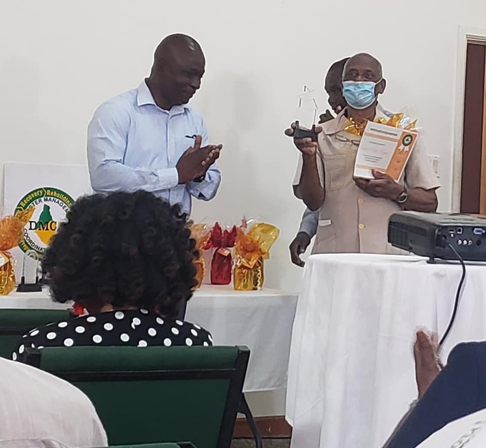
Photo: Mr Ryan accepting an award from DMCA in 2021 for his loyalty and dedication to the field of disaster management on Montserrat as a volunteer for 40 years.
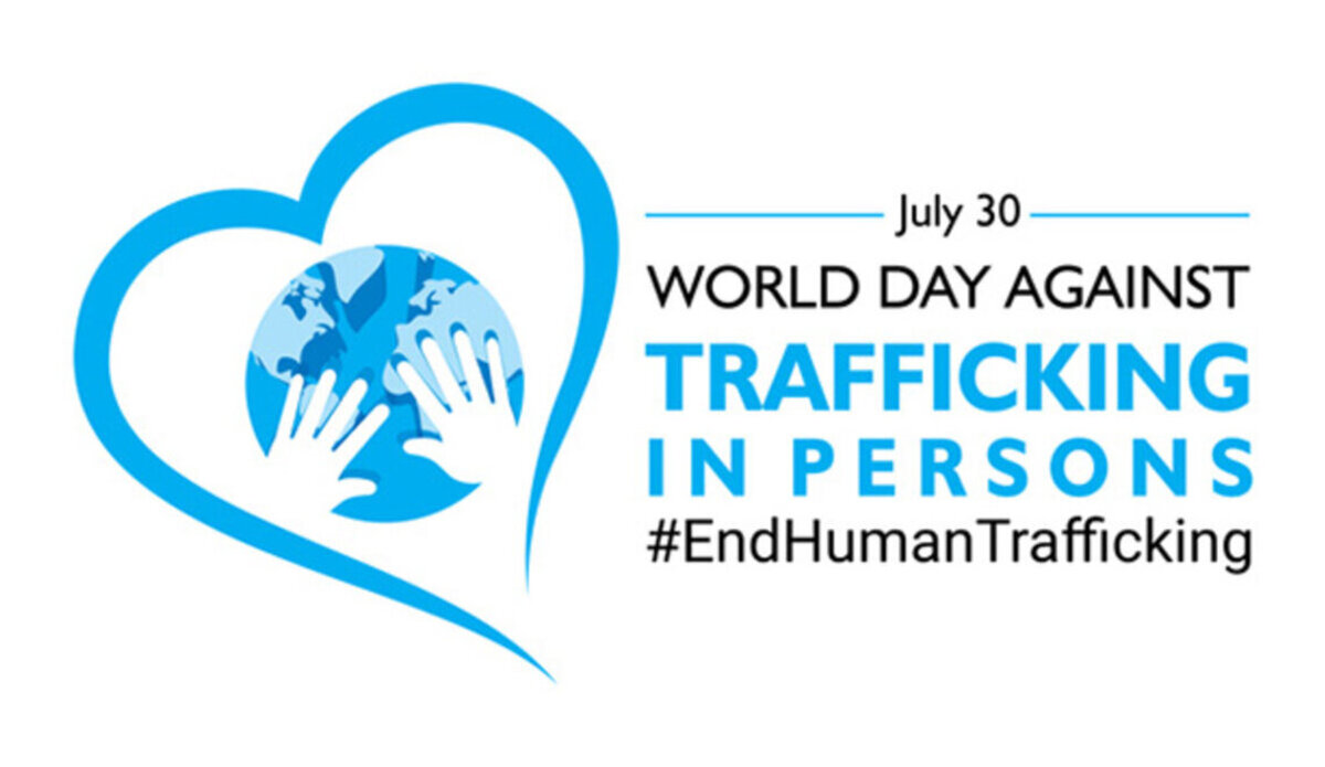
The Theme for this year is “Reach every victim of trafficking, leave no one behind”. The World Day Against Trafficking in Persons is observed annually on July 30 to raise awareness about human trafficking and to promote and protect the rights of trafficking victims.
While no activities are planned locally to mark the day, in this case, raising awareness is an important part of the Disaster Management Coordination Agency (DMCA)’s work, and is the crucial first step towards ensuring residents understand modern slavery and human trafficking.
Disasters, whether man-made or natural, have the potential to increase an individual’s vulnerability to human trafficking. Man-made disasters include political conflict, war, and terrorism. Natural disasters typically refer to the effects of climate change and extreme weather events such as droughts, wildfires, hurricanes, and floods. Disasters worsen vulnerabilities to human trafficking by creating problems such as displacement, public infrastructure failure, financial strain, and emotional distress.
Human trafficking is the act of compelling someone to work, for little or no pay, through force, fraud, or coercion.
Leave no one behind” is the central, transformative promise of the 2030 Agenda for Sustainable Development and its Sustainable Development Goals (SDGs).
vector illustration of World Day Against Trafficking in Persons poster or banner design
That’s according to the 2 PM tropical cyclone information statement issued by the Antigua and Barbuda Meteorological Services.
It states that Tropical disturbance AL95 is very unlikely to become a tropical cyclone before reaching the eastern Caribbean; hence, at the reasonable worst-case scenario, the system poses little threat to Montserrat. Nevertheless, you should have your hurricane disaster plan prepared for the hurricane season and monitor this disturbance until it is out of the area.
At 2 pm, Tropical Disturbance AL95 was centred about 570 miles southeast of the leeward islands and about 440 miles east of the windward Islands moving west at around 20 mph.
Maximum sustained winds are near 30 mph with higher gusts. Some slow development is possible during the next 48 hours; the system has a 20 percent chance of becoming a tropical cyclone in the next couple of hours.
Please note that no alerts, watches or warnings are currently in effect for the area and none is expected for this system.
Residents should continue to monitor tropical disturbance AL95 and ensure that they have their hurricane season plans prepared.
An update will be given around 2 pm tomorrow, or sooner if required.
The DMCA will continue to monitor the system and provide regular updates as deemed necessary.