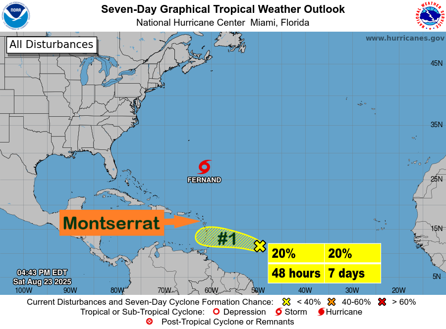
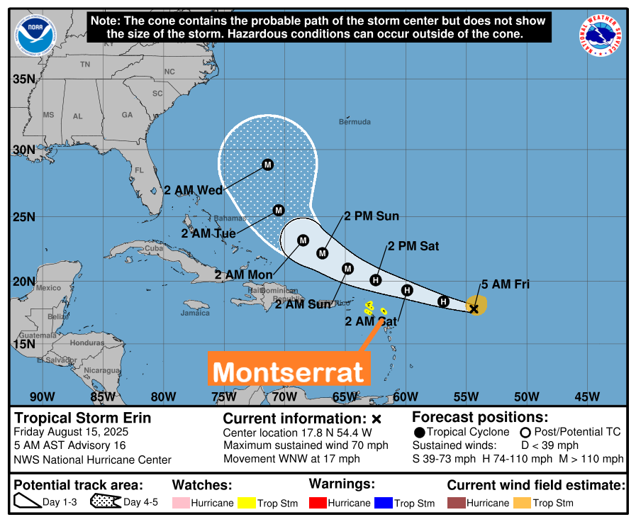
Tropical Disturbance AL95 is likely to pass south of the Leeward Islands including Montserrat early next week as it continues to approach the Caribbean, however, in the reasonable worst-case scenario, the system poses little threat to the island.

Nevertheless, this assessment is subject to change; to be safe, residents are advised to have their hurricane disaster plan prepared and closely monitor this disturbance until it is out of the area, according to the Antigua and Barbuda Meteorological Services.

It states that given the high uncertainty of the development, there is little confidence in the eventual strength and size of this system.

At 8:00 am, Tropical Disturbance AL95 is located several hundred miles east of the Windward Islands. While this system has not become significantly better organized since yesterday, some slow development remains possible during the next couple of days while it moves westward across the tropical Atlantic and into the eastern Caribbean Sea. Regardless of development, locally heavy rains and strong gusty winds are possible across portions of the Lesser Antilles during the next day or two.

The system has a 20 percent chance of becoming a tropical cyclone in 48 hours and 20 percent in seven days.

Based on the forecast model tracks, the system could be at the nearest point to the area on Tuesday. At this time, it could be a minimal tropical cyclone and may Possibly bring storm-force gusts to the islands and hazardous seas. Impacts, if any, are expected to be minimal.

Please note that no alerts, watches or warnings are currently in effect for the area and none might be needed for this system.

Residents should continue to monitor tropical disturbance AL95 and ensure that they have their hurricane season plans prepared.

An update will be given around 2 pm Today or sooner if required.

The DMCA will continue to monitor the system and provide regular updates as deemed necessary.

No photo description available.

Tropical Disturbance AL95 is likely to pass south of the Leeward Islands which includes Montserrat early next week and poses little threat to the island; however, residents should closely monitor this system until it is out of the area.

That’s According to the Antigua and Barbuda Meteorological Services.

It states that it’s closely following the progress of AL95 and given the high uncertainty of the development and forecast track, there is little confidence in the eventual strength, size and path of this system. However, in the reasonable worst-case scenario, AL95 poses little threat to the islands. Nevertheless, this assessment is subject to change, to be safe, have your hurricane disaster plan prepared and closely monitor this disturbance until it is out of the area.

At 8: 00 AM – Tropical Disturbance AL95 was located about 900 miles east of the Windward Islands. Although environmental conditions are only forecast to be marginally conducive for some gradual development, this system could still become a tropical depression during the next few days while it moves westward across the tropical Atlantic and eastern Caribbean Sea.

The system has a 30 percent chance of becoming a tropical cyclone in 48 hours and 40 percent in seven days.

Based on the forecast model tracks, the system could be at the nearest point to the area on Monday or Tuesday. At this time, it is likely to be a minimal tropical cyclone and could bring storm-force gusts to the islands and hazardous seas. Impacts, if any, are expected to be minimal.

Please note that no alerts, watches or warnings are currently in effect for the area; however, an alert is possible.

Residents on Montserrat should closely monitor Tropical Disturbance AL95 and ensure that they have their hurricane season plans prepared.

An update will be given around 2 pm today, or sooner if required.

The DMCA will continue to monitor the system and provide regular updates as deemed necessary.

May be an image of map and text that says 'All Disturbances Seven-Day Graphical Tropical Weather Outlook National Hurricane Center Miami, Florida EATHE TROPICAL STORM DON www.hurricanes.gov hurricanes. 45N 35N MONTSERRAT 25N Tropical Disturbance (AL95): 30% Chance of Cyclone Formation in 2 days a 40% probability in 7 days. 8:00 am EDT Sun Jul 23 2023 100W 90W 70WM 50W 40W Current Disturbances and Seven-Day Cyclone Formation Chance: x 40% Tropical or Sub- -Tropical Cyclone: o Depression Storm Post-Tropical Post- Cyclone or Remnants 5N 30W 40-60% Hurricane 20W 60%'

Air Quality Alert remains in effect for Montserrat today, Wednesday, 7 July 2023, due to Moderate Concentrations of Saharan Dust in the atmosphere across the island – Residents with respiratory and heart ailments are advised to take the necessary precautions!

According to an Air Quality Bulletin issued by the Antigua and Barbuda Meteorological Services, active children and adults, and, people with respiratory diseases such as asthma, should limit prolonged outdoor exertion.

Synopsis: The air quality is down to moderate levels as a result of particulate matters 2.5 and 10, associated with a fresh surge in the Saharan Dust. The threat of health problems is elevated, for mainly unusually sensitive people, such as asthmatics, and could potentially cause them limited health impacts.

Air quality index: 51 to 80

Alert Level: II

Sensitive groups: People with respiratory or heart disease, the elderly and children are the groups most at risk.

Health implications: Air quality is acceptable; however, for some pollutants, there may be moderate health concerns for a very small number of people who are unusually sensitive to air pollution.

The Disaster Management Coordination Agency (DMCA) is advising residents who are unusually sensitive to dust particles to be vigilant, due to moderate concentrations of Saharan dust in the atmosphere! Residents with respiratory issues such as asthma should keep windows and doors closed as much as possible.

The DMCA is further advising residents to limit dust entering their system as best as possible by using masks and protective eyewear. Any masks that filter small particles should be worn such as a surgical mask, N95 and KN95 when going outside.

Continue to monitor DMCA Facebook, Instagram and Twitter social media sites and our website http://dmca.gov.ms for daily weather updates, public advisories and warnings and information on the wide range of natural and man-made hazards that have the potential to impact Montserrat.

Photos Courtesy: myFoxhurricane

Air Quality Alert: Moderate Concentrations of Saharan Dust present in the atmosphere across Montserrat today, Friday, 30 June 2023, due to a fresh surge in the Saharan Dust – Persons with respiratory and heart ailments are advised to take the necessary precautions!

According to an Air Quality Bulletin issued by the Antigua and Barbuda Meteorological Services, active children and adults, and, people with respiratory diseases such as asthma, should limit prolonged outdoor exertion.

Synopsis: The air quality is down to moderate levels as a result of particulate matters 2.5 and 10, associated with a fresh surge in the Saharan Dust. The threat of health problems is elevated, for mainly unusually sensitive people, such as asthmatics, and could potentially cause them limited health impacts.

Air quality index: 51 to 80

Alert Level: II

Sensitive groups: People with respiratory or heart disease, the elderly and children are the groups most at risk.

Health implications: Air quality is acceptable; however, for some pollutants, there may be moderate health concerns for a very small number of people who are unusually sensitive to air pollution.

The Disaster Management Coordination Agency (DMCA) is advising residents who are unusually sensitive to dust particles to be vigilant, due to moderate concentrations of Saharan dust in the atmosphere! Residents with respiratory issues such as asthma should keep windows and doors closed as much as possible.

The DMCA is further advising residents to limit dust entering their system as best as possible by using masks and protective eyewear. Any masks that filter small particles should be worn such as a surgical mask, N95 and KN95 when going outside.

Continue to monitor DMCA Facebook, Instagram and Twitter social media sites and our website http://dmca.gov.ms for daily weather updates, public advisories and warnings and information on the wide range of natural and man-made hazards that have the potential to impact Montserrat.

Photos Courtesy: myFoxhurricane

Urgent – Marine Weather Message – Small Craft Advisory goes into effect late Tuesday until Wednesday for mainly open waters on the Atlantic side of Montserrat out to 20 nautical miles.

According to a Small Craft Advisory issued by Antigua and Barbuda Meteorological Services, inexperienced mariners, especially those operating smaller vessels should avoid navigating in these conditions.

Synopsis: A combination of wind waves and wind swells is expected to cause hazardous seas, especially on the Atlantic sides of the islands. The threat level to the life, livelihood, property and infrastructure of mariners is to rise to moderate with the potential for significant impacts. A small craft advisory means that wind speeds of 21 to 33 knots and or wind waves and or wind swells of 7 feet or greater are occurring or imminent.

Winds Over Open Waters: East-southeast at 24 to 37 km/h (13 to 20 knots; 15 to 23 mph), with strong gusts to 57 km/h (31 knots; 36 mph).

Seas (significant wave heights): 1.5 to 2.4 metres (5 to 8 feet), occasionally or locally reaching near 3 metres (10 feet). Wind waves and or wind swells of 1.5 to 2.4 metres or 5 to 8 feet and occasionally higher. The dominant wind-wave period is 6 to 9 seconds. Seas will peak on Wednesday.

Potential Impacts: Loss of life at sea; injuries to mariners; capsize or damage or loss of vessels and marine equipment; financial losses; disruption of fisheries and scarcity of fish products and disruption to marine transportation.

Forecaster: Dale Destin

As Montserratians reflect on the catastrophic 1997 Soufrière Hills Volcanic Eruption today; DMCA highlights the importance of Developing a “culture of disaster preparedness” on Montserrat to natural and technological hazards!

26 years ago, on Wednesday, June 25, 1997; after two years after the start of volcanic activities on Montserrat; 19 people tragically lost their lives at approximately 12:55 pm, when a dome collapsed at the Soufriere Hills Volcano occurred.

In the following 25 minutes, a series of devastating flows (the largest pyroclastic flows to date) swept the northern flanks of the volcano, down Mosquito Ghaut and followed the Paradise River almost to the sea

The flows and associated surge clouds damaged or destroyed between 100 to 150 houses, with the villages of Streatham, Dyers, Harris, Bethel, Bramble, Trants, Farms and Spanish Point.

Initially, 8 people were confirmed dead, and a further 11 were missing. Five people also suffered serious burns.

Today, as we reflect and remember the June 25th, 1997 catastrophic volcanic eruption, we take a moment of silence to mourn and pay our respect to the nineteen individuals who lost their lives in the eastern corridors where the fertile lands were located, engaging in sustenance farming, to supply not only their households but also the wider Montserrat community.

Montserrat, due to its geographical location and is situated in a seismically active region is vulnerable to many natural and man-made hazards such as volcanic eruptions, earthquakes, tsunamis, hurricanes, tropical storms, flash floods, lahars, landslides, fires, pandemics, cyberattacks and terrorism among many others. Hence, developing a “culture of disaster preparedness is a must.

Creating a culture of preparedness is much more than creating an emergency supply kit and a disaster plan to protect families and businesses. It means examining and preparing for all types of natural hazards that can impact your homes, businesses, and communities. Establishing a Culture of Preparedness also means residents practicing their emergency plans with formal and informal drills and exercises and ensuring that adult family and business members can activate the plan. Also, a culture of Preparedness includes regular updates to family, business, and organizational emergency plans and emergency contact information for the ultimate protection of families and businesses.

The power of “simple things” such as setting up personal emergency plans together with your family and friends by discussing emergency contacts, meeting points, means of communication etc. Use simple reminders to have these emergency plans and information readily available, e.g., as a pic on your mobile phone, in your purse, or to stick on the fridge. Also, be on the lookout for publicly displayed information about how to prepare for emergencies or disasters.

Disaster preparedness, combined with updated risk information, and timely assessments of damages and needs, are critical to responding to any potential hazard impact.

May be an image of fire and fog

TROPICAL STORM CINDY IS PASSING WELL NORTH OF MONTSERRAT; WE ARE IN THE CLEAR FOR NOW -RESIDENTS SHOULD CONTINUE TO MONITOR THE HURRICANE SEASON AND HAVE THEIR HURRICANE PLANS PREPARED!


THAT’S ACCORDING TO THE 11 AM TROPICAL CYCLONE INFORMATION STATEMENT ISSUED BY THE ANTIGUA AND BARBUDA METEOROLOGICAL SERVICES SUNDAY JUNE 25 2023 TROPICAL STORM CINDY.

IT STATES THAT NO ALERTS, WATCHES OR WARNINGS ARE CURRENTLY IN EFFECT FOR MONTSERRAT.

TO BE SAFE DURING THE HURRICANE SEASON, RESIDENTS MUST HAVE THEIR DISASTER PLANS PREPARED, AND STAY VIGILANT.

AT 11 AM, TROPICAL STORM CINDY WAS LOCATED ABOUT 330 MILES NORTHEAST OF THE LEEWARD ISLANDS MOVING NORTHWEST AND FURTHER AWAY FROM THE AREA AT 17 MPH.

MAXIMUM SUSTAINED WINDS HAVE DECREASED TO NEAR 45 MPH WITH HIGHER GUSTS. ADDITIONAL WEAKENING IS FORECAST DURING THE NEXT 36 HOURS, AND CINDY IS EXPECTED TO DEGENERATE INTO A TROUGH OF LOW PRESSURE BY MONDAY NIGHT.

May be an image of map and text


THIS IS THE LAST INFORMATION STATEMENT ON THIS SYSTEM.

FORECASTER DALE DESTIN

THE ANTIGUA AND BARBUDA MET SERVICES SAYS DUE TO THE RELATIVELY HIGH CERTAINTY IN THE FORECAST TRACK, THERE IS HIGH CONFIDENCE THAT TROPICAL STORM CINDY WILL PASS A VERY SAFE DISTANCE AWAY FROM MONTSERRAT. EVEN UNDER THE REASONABLE WORST-CASE SCENARIO, THE SYSTEM POSES LITTLE THREAT TO THE ISLAND.

ACCORDING TO A TROPICAL CYCLONE INFORMATION STATEMENT ISSUED BY THE ANTIGUA AND BARBUDA METEOROLOGICAL SERVICES TODAY, SATURDAY JUNE 24 2023, IT STATES THAT IT IS FOLLOWING THE PROGRESS OF TROPICAL STORM CINDY, WHICH IS EXPECTED TO PASS NORTH OF THE LEEWARD ISLANDS INCLUDING MONTSERRAT EARLY NEXT WEEK. NEVERTHELESS, TO BE SAFE, RESIDENT SHOULD HAVE THEIR HURRICANE DISASTER PLANS PREPARED AND MONITOR THIS STORM UNTIL IT IS OUT OF THE AREA.

NO ALERTS, WATCHES OR WARNINGS ARE CURRENTLY IN EFFECT FOR MONTSERRAT, AND THIS IS UNLIKELY TO CHANGE.

AT 5 AM, TROPICAL STORM CINDY WAS LOCATED ABOUT 715 MILES EAST SOUTHEAST OF THE LEEWARD ISLANDS MOVING WEST-NORTHWEST AT 15 MPH.

MAXIMUM SUSTAINED WINDS ARE NEAR 60 MPH WITH HIGHER GUSTS. SOME GRADUAL WEAKENING IS FORECAST INTO EARLY NEXT WEEK.

BASED ON THE FORECAST TRACK, THE SYSTEM IS LIKELY TO PASS OVER 200 MILES AWAY FROM THE AREA ON SUNDAY OR MONDAY. MOISTURE TRAILING CINDY COULD BRING LOCALLY HEAVY

RAINFALL TO THE ISLANDS AROUND MIDWEEK. THE SPECIFIC IMPACT WILL DEPEND ON THE EVENTUAL TRACK AND FORWARD SPEED OF THE SYSTEM.

May be an image of map and text

RESIDENTS SHOULD CONTINUE TO MONITOR TROPICAL STORM CINDY AND ENSURE THEIR HURRICANE SEASON PLANS ARE PREPARED.

THE NEXT UPDATE WILL BE GIVEN AT AROUND 8 AM SUNDAY, OR SOONER IF REQUIRED.

FORECASTER DALE DESTIN

THE ANTIGUA AND BARBUDA MET SERVICES SAYS ITS CLOSELY FOLLOWING THE PROGRESS OF NEWLY FORMED TROPICAL STORM CINDY, WHICH IS EXPECTED TO PASS NORTH OF THE LEEWARD ISLANDS INCLUDING MONTSERRAT EARLY NEXT WEEK.

ACCORDING TO A TROPICAL CYCLONE INFORMATION STATEMENT ISSUED BY THE ANTIGUA AND BARBUDA METEOROLOGICAL SERVICES TODAY, FRIDAY 23 JUNE 2023, GIVEN THE RELATIVELY HIGH CERTAINTY OF THE FORECAST TRACK, THERE IS HIGH CONFIDENCE THAT CINDY WILL PASS A SAFE DISTANCE AWAY FROM THE AREA. EVEN UNDER THE REASONABLE WORST-CASE SCENARIO, THE SYSTEM POSES LITTLE DIRECT THREAT TO THE ISLANDS. NEVERTHELESS, THIS ASSESSMENT IS SUBJECT TO CHANGE, TO BE SAFE, HAVE YOUR HURRICANE DISASTER PLAN PREPARED AND CLOSELY MONITOR THIS STORM UNTIL IT IS OUT OF THE AREA.

AT 9 AM, TROPICAL STORM CINDY WAS LOCATED ABOUT 1020 MILES SOUTHEAST OF THE LEEWARD ISLANDS MOVING WEST AT 15 MPH.

MAXIMUM SUSTAINED WINDS ARE NEAR 45 MPH WITH HIGHER GUSTS. ADDITIONAL DEVELOPMENT IS EXPECTED DURING THE NEXT COUPLE OF DAYS.

BASED ON THE FORECAST TRACK, THE SYSTEM COULD BE AT THE NEAREST POINT TO THE AREA ON SUNDAY OR MONDAY. THEREAFTER, DURING THE FIRST HALF OF NEXT WEEK, CINDY COULD BRING LOCALLY HEAVY RAINFALL AND GUSTY WINDS TO THE ISLANDS. THE SPECIFIC IMPACT WILL DEPEND ON THE INTENSITY, SIZE, TRACK AND FORWARD SPEED OF THE SYSTEM.

PLEASE NOTE THAT NO ALERTS, WATCHES OR WARNINGS ARE CURRENTLY IN EFFECT FOR THE AREA, AND THIS IS UNLIKELY TO CHANGE.

RESIDENTS SHOULD CLOSELY MONITOR TROPICAL STORM CINDY AND ENSURE THEY HAVE THEIR HURRICANE SEASON PLANS PREPARED.

May be an image of map and text that says 'The cone contains the probable path of storm center does not show the size storm. Hazardous conditions can outside the cone. Bermuda 25N Wed AM Sun 8PM Sun 10N AM 8PM Sat MONTSERRAT AMFri TROPICAL STORM CINDY 75W 90W Tropical Storm Cindy Friday June 23, 2023 AST Advisory 6 NWS National Hurricane Center Current information: Center location Maximum sustained wind mph Movement WNW mph Potential track area: Watches: Hurricane 40W Forecast positions: Tropical Cyclone Post/Potential TC Sustained winds: 39 mph S39-73 mph 74-110 mph 110 mph Warnings: Trop Stm Hurricane Trop Stm Current wind field estimate: Hurricane Trop Stm'

AN UPDATE WILL BE GIVEN AROUND 11 PM TONIGHT, OR SOONER IF REQUIRED.

FORECASTER DALE DESTIN

5 AM UPDATE: A TROPICAL CYCLONE ALERT REMAINS IN EFFECT FOR MONTSERRAT – NO SPECIFIC ACTION IS REQUIRED OF RESIDENTS OTHER THAN TO KEEP MONITORING THE MOVEMENT OF TROPICAL STORM BRET!

THAT’S ACCORDING TO THE 5 AM TROPICAL ALERT STATEMENT ISSUED BY THE ANTIGUA AND BARBUDA METEOROLOGICAL SERVICES ON FRIDAY, 23 JUNE 2023.

IT STATES THAT ON ITS PRESENT TRACK, THE CENTRE OF TROPICAL STORM BRET IS FORECAST TO MOVE FURTHER INTO THE CARIBBEAN SEA AND AWAY FROM THE WINDWARD ISLANDS DURING THE COMING DAYS.

SOME WEAKENING IS EXPECTED THIS MORNING, HOWEVER, RAINBANDS WILL CONTINUE TO PRODUCE RAIN AND STRONG WINDS IN PORTIONS OF THE WINDWARD ISLANDS.
,
AT 5 AM, THE CENTRE OF TROPICAL STORM BRET WAS LOCATED NEAR LATITUDE 13.4 NORTH, LONGITUDE 62.9 WEST OR ABOUT 231 MILES SOUTH-SOUTHWEST OF THE LEEWARD ISLANDS AND 316 MILES SOUTH-SOUTHEAST OF THE BRITISH VIRGIN ISLANDS TROPICAL STORM BRET IS MOVING TOWARD THE WEST AT 18 MPH AND THIS GENERAL MOTION IS LIKELY TO CONTINUE THROUGH THE WEEKEND.

MAXIMUM SUSTAINED WINDS HAVE DECREASED TO NEAR 60 MPH WITH HIGHER GUSTS. FURTHER WEAKENING IS ANTICIPATED AND BRET IS EXPECTED TO DISSIPATE OVER THE CENTRAL CARIBBEAN SEA BY SATURDAY NIGHT OR SUNDAY.

TROPICAL STORM FORCE WINDS EXTEND OUTWARD UP TO 125 MILES FROM THE CENTRE.

THE ESTIMATED MINIMUM CENTRAL PRESSURE IS 1001 MB OR 29.56 INCHES.

THE NEXT ADVISORY WILL BE AT 11 AM.

FORECASTER JALEEL JACOBS