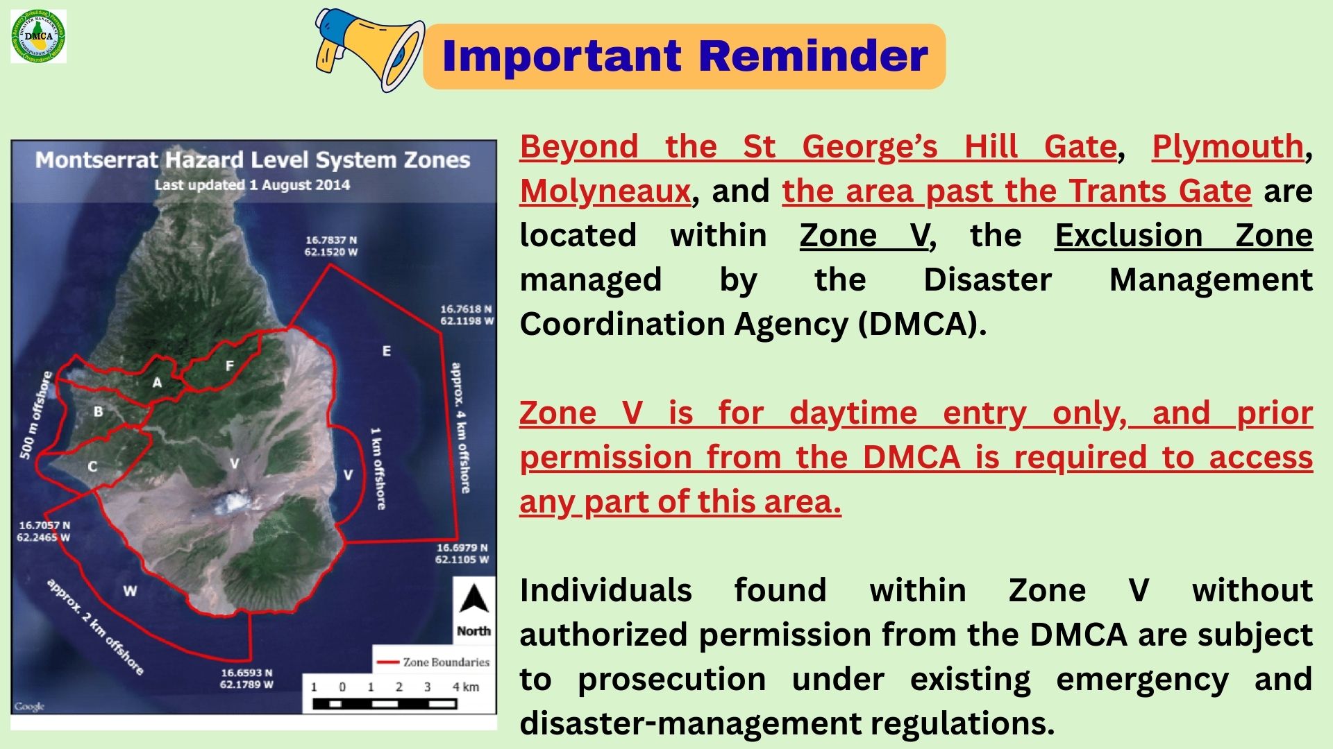
Beyond St George’s Hill Gate, Plymouth, Molyneaux, and past Trants Gate lies Zone V, the Exclusion Zone managed by the Disaster Management Coordination Agency (DMCA).
Daytime entry only — prior permission from the DMCA is required.
Unauthorized entry is subject to prosecution under emergency and disaster-management regulations.
The disturbance, now designated Invest 98L, is expected to bring showers and thunderstorms across Montserrat today and into Monday. ? Rainfall totals for the period could range between 0.5 and 1 inch, with locally higher amounts possible. A Flash Flood Advisory may be required.
This weather system could disrupt normal daily activities. While the risk to life and property remains low, the public is advised to stay vigilant for potential adverse weather conditions and follow the latest forecasts.
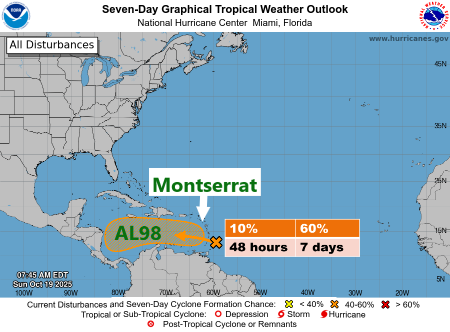
Invest 98L, located near the Windward Islands, is moving quickly westward at 20 to 25 mph into the eastern Caribbean Sea. Further development is expected to be limited over the next day or two due to the system’s fast forward motion.
However, the system is forecast to slow down over the central Caribbean Sea by the middle of the week, where environmental conditions could become more favourable for development. A tropical depression could form over the central Caribbean Sea by the middle to latter part of the week.
? Formation Chances:
Next 48 hours: Low (10%)
Next 7 days: Medium (60%)
Residents are urged to stay vigilant, prepared, and informed, and to continue monitoring official DMCA updates as we remain in the hurricane season.
? The DMCA will continue to monitor this system and provide updates as necessary.
ANTIGUA AND BARBUDA METEOROLOGICAL SERVICES 9:21 AM, THURSDAY, OCTOBER 16, 2025
A Flash Flood Watch is in effect for low-lying and flood-prone areas of Montserrat, valid until 4 p.m. today.
A Flash Flood Watch means that moderate to major flooding is possible but not imminent in the watch area. Flash flooding is a very dangerous situation.
Residents in low-lying and flood-prone areas should make preparations to safeguard life and property. Be ready to move to higher ground if flooding rains develop or if a Flash Flood Warning is issued.
A persistent trough over the northeastern Caribbean is influencing weather conditions across the area, producing periodic heavy showers and thunderstorms. Radar estimates indicate that over 2 inches of rain have already fallen in some places during the last six hours, with another 2 to 4 inches or more possible in the next 12 hours. As a result, minor flooding of low-lying and flood-prone areas is expected.
The Antigua and Barbuda Meteorological Services will continue to monitor the weather situation and issue updates as necessary.
ANTIGUA AND BARBUDA METEOROLOGICAL SERVICES THU, OCT 9, 2025
THIS IS FOR MONTSERRAT
…JERRY EXPECTED TO BE NEAR THE NORTHERN LEEWARD ISLANDS THIS EVENING AND TONIGHT…
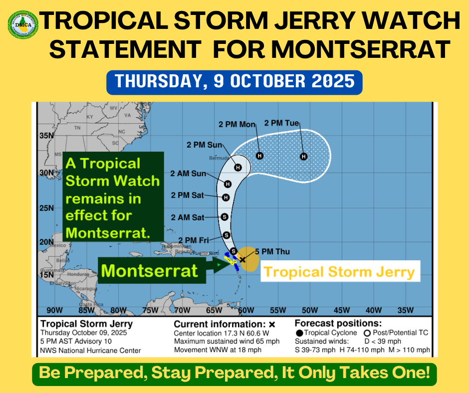
A Tropical Storm Watch remains in effect for Montserrat. A Tropical Storm Watch means that tropical storm conditions are possible within the watch area, in this case, within 12 hours.
At 5:00 PM AST (2100 UTC), the center of Tropical Storm Jerry was located near latitude 17.3° North, longitude 60.6° West, or about 111 miles east-northeast of Montserrat.
Jerry is moving toward the west-northwest near 18 mph. A turn toward the northwest is expected this evening, followed by a slightly slower northward motion on Friday and Saturday. On the forecast track, the center of Jerry is expected to pass near the northern Leeward Islands this evening and tonight.
Maximum sustained winds remain near 65 mph with higher gusts. Little change in strength is expected through tomorrow, but slow strengthening is possible over the weekend.
Tropical-storm-force winds extend outward up to 175 miles, mainly east of the center.
The estimated minimum central pressure is 1001 mb.
Based on the latest observations and analysis, the core of Jerry is expected to pass near or to the north of the northern Leeward Islands later today into Friday, causing gusty conditions mainly in showers.
Rainfall totals of 2 to 4 inches are possible during Jerry’s passage, which could cause minor to moderate flooding, mainly in low-lying and flood-prone areas.
Swells generated by Jerry are expected to reach the Leeward Islands this afternoon. These conditions are likely to cause life-threatening surf and rip currents; hence, mariners are strongly advised to remain in port.
Residents should continue preparing for the possibility of storm conditions, and if the watch is upgraded to a warning, be ready to complete preparations quickly.
Antigua and Barbuda Meteorological Services Thursday, October 9, 2025
This statement is for Montserrat
…Tropical storm conditions possible over portions of the northern Leeward Islands when Jerry passes nearby late Thursday and Thursday night…
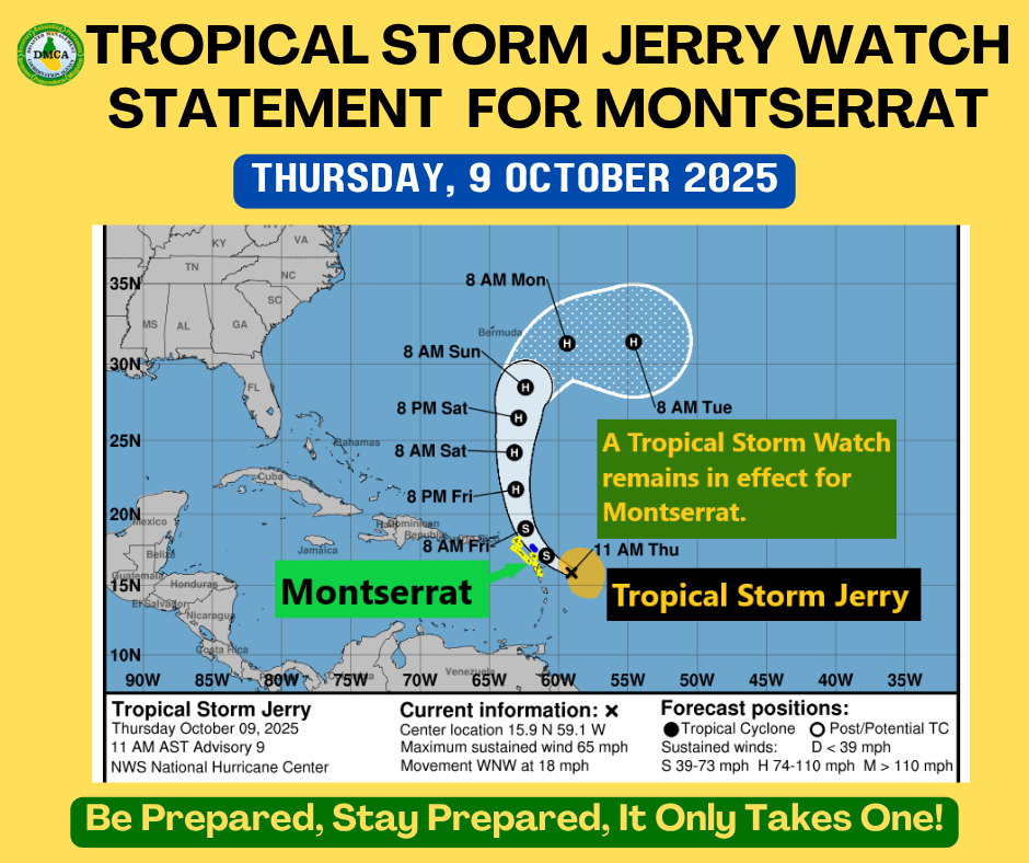
A Tropical Storm Watch remains in effect for Montserrat. A Tropical Storm Watch means that tropical storm conditions pose a possible threat to the specified area within 48 hours.
At 11:00 AM AST (1500 UTC), the center of Tropical Storm Jerry was located near latitude 15.9° North, longitude 59.1° West, or about 215 miles east-southeast of Montserrat.
Jerry is moving toward the west-northwest near 18 mph, and this general motion is expected to continue through today. A turn toward the northwest is expected later today, followed by a slightly slower northward motion Friday and Saturday. On the forecast track, the center of Jerry is expected to pass near or to the northeast of the northern Leeward Islands later today and tonight.
Maximum sustained winds are near 65 mph with higher gusts. Gradual strengthening is forecast during the next few days, and Jerry could become a hurricane by late Friday or Saturday.
Tropical-storm-force winds extend outward up to 175 miles, mainly east of the center. The estimated minimum central pressure is 999 mb (29.50 inches).
Based on the latest observations and analysis, the core of Jerry is expected to be near or north of the northern Leeward Islands later today into Friday, producing gusty conditions mainly in showers.
Rainfall totals of 2 to 4 inches are possible during the passage of Jerry, which could cause minor to moderate flooding, particularly in low-lying and flood-prone areas.
Swells generated by Jerry are expected to reach the Leeward Islands this afternoon. These swells are likely to cause life-threatening surf and rip current conditions; mariners are strongly advised to remain in port.
Residents should continue to monitor the progress of Jerry and be prepared for the possibility of storm conditions.
Repeating the 11:00 AM position: Latitude 15.9°N, Longitude 59.1°W. Movement toward the west-northwest near 18 mph. Maximum sustained winds 65 mph. Minimum central pressure 999 mb.
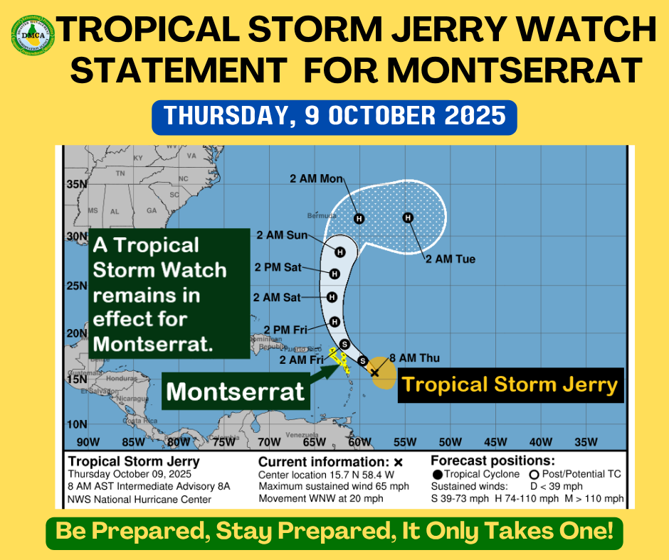
ANTIGUA AND BARBUDA METEOROLOGICAL SERVICES THURSDAY, OCTOBER 9, 2025
FOR MONTSERRAT
…TROPICAL STORM CONDITIONS POSSIBLE ON PORTIONS OF THE NORTHERN LEEWARD ISLANDS AS JERRY PASSES NEARBY LATE THURSDAY AND THURSDAY NIGHT…
A Tropical Storm Watch remains in effect for Montserrat. A Tropical Storm Watch means that tropical storm conditions pose a possible threat to the specified area within 48 hours.
At 8:00 AM, the center of Tropical Storm Jerry was located near latitude 15.7°N, longitude 58.4°W, or about 263 miles east-southeast of Montserrat.
Jerry is moving toward the west-northwest near 20 mph, and this general motion is expected to continue through today. A turn toward the northwest is expected later today, followed by a slightly slower northward motion on Friday and Saturday.
On the forecast track, the center of Jerry is expected to pass near or to the northeast of the northern Leeward Islands later today and tonight.
Maximum sustained winds: 65 mph, with higher gusts. Gradual strengthening is forecast during the next few days, and Jerry could become a hurricane by late Friday or Saturday.
Tropical-storm-force winds extend outward up to 175 miles, mainly east of the center.
Minimum central pressure: 999 mb.
Based on the latest analysis, the core of Jerry is expected to be near or north of the northern Leeward Islands later today into Friday, causing gusty conditions mainly in showers. Rainfall totals of 2 to 4 inches are possible during Jerry’s passage, which could result in minor to moderate flooding, mainly in low-lying and flood-prone areas.
Swells generated by Jerry are expected to reach the Leeward Islands this afternoon. These swells could cause life-threatening surf and rip current conditions. Mariners are strongly advised to remain in port.
Residents should closely monitor the progress of Jerry and be prepared for possible storm conditions.
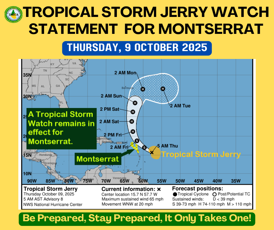
ANTIGUA AND BARBUDA METEOROLOGICAL SERVICES THURSDAY, OCTOBER 9, 2025
THIS IS FOR MONTSERRAT
…TROPICAL STORM CONDITIONS POSSIBLE ON PORTIONS OF THE NORTHERN LEEWARD ISLANDS AS JERRY PASSES NEARBY LATE THURSDAY INTO THURSDAY NIGHT…
A Tropical Storm Watch remains in effect for Montserrat. A Tropical Storm Watch means that tropical storm conditions pose a possible threat to the specified area within 48 hours.
At 5:00 AM, the center of Tropical Storm Jerry was located near latitude 15.7° North, longitude 57.7° West, or about 267 miles east-southeast of Montserrat.
Jerry is moving toward the west-northwest near 20 mph, and this general motion is expected to continue through today. A northwestward motion at a slower forward speed should begin tonight, followed by a northward motion on Friday and Saturday.
On the forecast track, the center of Jerry is expected to pass near or to the northeast of the northern Leeward Islands later today and tonight.
Maximum sustained winds are near 65 mph with higher gusts. Gradual strengthening is forecast during the next few days, and Jerry could become a hurricane by late Friday or Saturday.
Tropical-storm-force winds extend outward up to 185 miles, mainly east of the center.
The estimated minimum central pressure is 999 mb.
Based on the latest observation and analysis, the core of Jerry is expected to be near or just north of the northern Leeward Islands later today into Friday, bringing gusty conditions mainly in showers.
Rainfall totals of 2 to 4 inches are possible during the passage of Jerry, which could cause localized flooding in low-lying and flood-prone areas.
Swells generated by Jerry are expected to reach the Leeward Islands this afternoon. These conditions are likely to cause life-threatening surf and rip currents; therefore, mariners are advised to remain in port.
No specific action is required of residents other than to closely monitor the progress of Jerry.
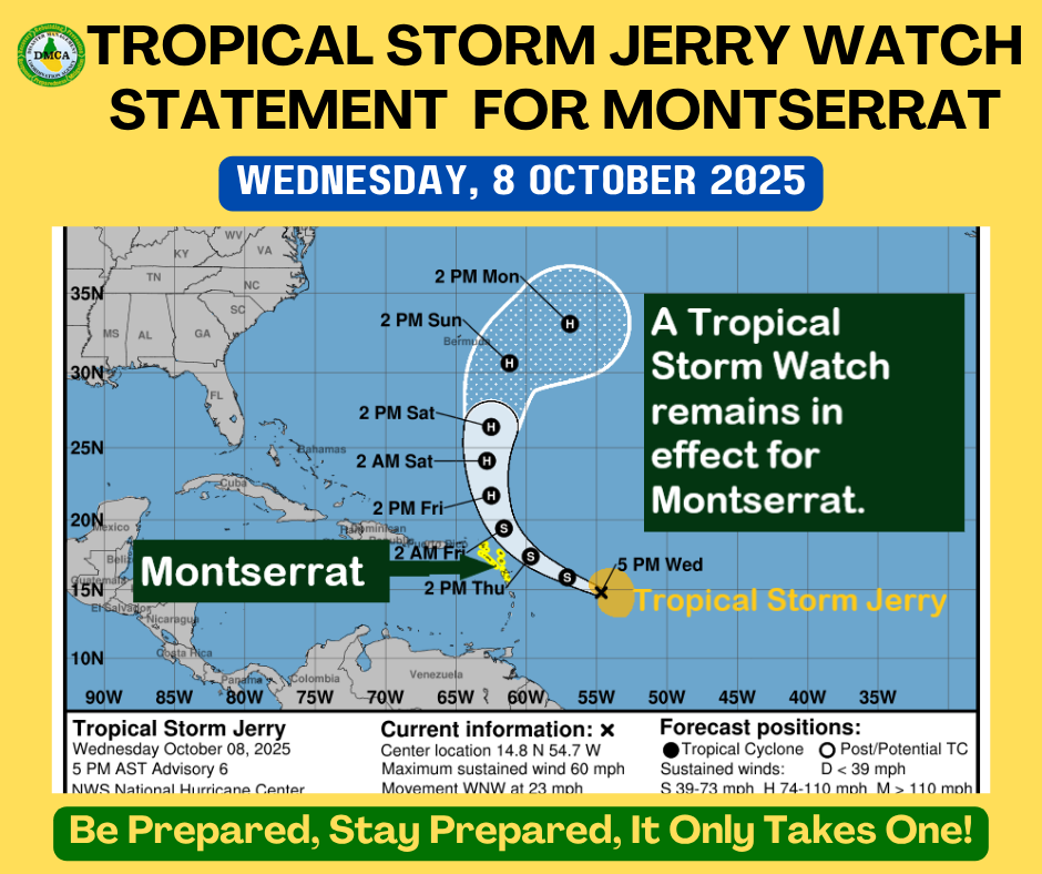
…TROPICAL STORM CONDITIONS POSSIBLE ACROSS PORTIONS OF THE NORTHERN LEEWARD ISLANDS WHEN JERRY PASSES NEARBY LATE THURSDAY INTO THURSDAY NIGHT…
A Tropical Storm Watch remains in effect for Montserrat.
A Tropical Storm Watch means that tropical-storm conditions pose a possible threat to the specified area within 48 hours.
At 5:00 PM, the center of Tropical Storm Jerry was located near latitude 14.8° North, longitude 54.7° West, or about 449 miles east-southeast of Montserrat.
Jerry is moving toward the west-northwest at 23 mph. This general motion is expected to continue through Thursday. A northwestward motion at a slower forward speed should begin Thursday night, followed by a northward motion Friday night into Saturday.
On the forecast track, the center of Jerry is expected to pass near or to the northeast of the northern Leeward Islands late Thursday into Thursday night.
Maximum sustained winds are near 60 mph, with higher gusts. Gradual strengthening is forecast over the next few days, and Jerry could become a hurricane late this week or over the weekend.
Tropical-storm-force winds extend outward up to 175 miles from the center. The estimated minimum central pressure is 1000 mb.
POTENTIAL IMPACTS FOR MONTSERRAT
The core of Jerry is expected to pass near or to the north of the northern Leeward Islands late Thursday into Friday, causing gusty conditions mainly in showers.
Rainfall totals of up to 3 inches are possible during the passage of Jerry, which could cause localized flooding, especially in low-lying and flood-prone areas.
Swells generated by Jerry are expected to reach the Leeward Islands on Thursday, producing hazardous surf and life-threatening rip currents.
?? Mariners are advised to remain in port until conditions improve.
At this time, no specific action is required of residents other than to closely monitor the progress of Jerry and ensure that preparedness plans are in place.
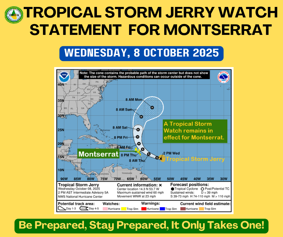
Tropical Storm Jerry continues moving quickly west-northwestward.
A Tropical Storm Watch remains in effect for Montserrat.
A Tropical Storm Watch means that tropical storm conditions pose a possible threat to the specified area within 48 hours.
At 2:00 PM, the center of Tropical Storm Jerry was located near latitude 14.3 North, longitude 53.7 West. Jerry is moving toward the west-northwest near 23 mph, and this general motion is expected to continue through early Thursday.
A turn toward the northwest and then north at a slower forward speed is expected late Thursday into Saturday.
On the forecast track, the center of Jerry is expected to pass near or to the northeast of the northern Leeward Islands late Thursday and Thursday night.
Data from a NOAA Hurricane Hunter aircraft indicate that maximum sustained winds have increased to near 60 mph with higher gusts. Gradual strengthening is forecast during the next few days, and Jerry could become a hurricane by the weekend.
Tropical-storm-force winds extend outward up to 125 miles from the center. The estimated minimum central pressure is 1003 mb.
Based on the latest observations and analysis, the core of the system is expected to be near or north of the northern Leeward Islands late Thursday into Friday, producing gusty conditions mainly in showers.
Rainfall totals of up to 3 inches are possible during the passage of Jerry, which could result in localized flooding, especially in low-lying and flood-prone areas.
Swells generated by Jerry are expected to reach the Leeward Islands on Thursday. These swells are likely to cause life-threatening surf and rip current conditions; mariners are strongly advised to remain in port.
All residents and visitors on Montserrat are urged to monitor the movement of Jerry closely and stay alert for further updates.